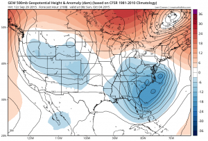
Given all the dynamics that we are dealing with the afternoon GFS Model run seems to have aired a degree of logic to what has been a day where models were once again everywhere in their analysis and their solutions. We have stated all along that the key to Tropical Storm Joaquin or possibly Hurricane Joaquin would be how the upper trough that develops in the east ultimatly reacts and deals with the tropical system.
The GFS model 102 hour and the Canadian 108 hour which are for the same time frame Saturday night are very similar and quite different from the European. The European completely separates the southern part of the trough and it could be because the European drives a deeper trough into the Western states verses the other models which have a less dynamic look in the west. The further south look of the European forces it to swing the hurricane or tropical storm out well to the east toward Bermuda before turning it northward.
Now just because 2 models agree compared to the third doesn’t mean majority rules here. The European’s look could be more correct. The Gfs model earlier today looked more like the European did but it has now come to this different look which matches the Canadian. The result of the GFS and Canadian model is to take a storm northward and then northwestward into Chesapeake or Delaware Bay!
Again I want to emphasize that I am putting this up as a illustration of what the models are doing and not as a forecast, nor am I saying that the above 2 models are correct. The key will be the structure of that deep upper trough in the east and whether it is able to capture and steer the tropical system northward and then northwestward in time. In some sense this is what the European did yesterday.
It is not unusual for models to flip back and forth only to go back to solutions they originally arrived at. At this stage of the game it is a matter of watching and waiting as numerous other models that are hurricane driven go in all sorts of directions. Ultimately I think that this will also depend on how deep a system we are dealing with regarding Tropical Storm Joaquin and how it responds to the strong southerly flow that develops along the east coast around that upper low. Look for more flip flops tonight and tomorrow. Regardaless of whether the tropical storm becomes a player, with strong high pressure to the north and this deep upper trough and low pressure to the south, we should see heavy rains and noreaster conditions here late Friday and into the weekend. It becomes a matter of whether the models are correct in making a hurricane and getting it completely involved in this mix. Remember too that the global models have not done well at all with tropical systems these last 2 months making hurricanes that ultimately didnt exist. The difference here is that we do have something tangible in Tropical Storm Joaquin.
With noreaster conditions looming and the possibility that Tropical Storm Joaquin could be come a hurricane and effect the Middle Atlantic and Northeast, download my weather app and subscribe to my forecasts. The zones include the New York area, New Jersey, Eastern Pennsylvania and Connecticut. This includes Long Island and the Hudson valley. The app is free and the subscription is just 99 cents a month. The app is free from advertising and there are no security issues or tracking issues.


