
La Nina Developing El Nino Weakens

MENTION JOE CIOFFI AND GET A 5% DISCOUNT
It appears that a number of changes are beginning to take shape across the Pacific that are leading to La Nina developing El Nino weakens. Latest sea water temperature analysis clearly show changes in both the Northern & Equatorial Pacific that are very important to the long range weather outlook as we move through the spring and summer.
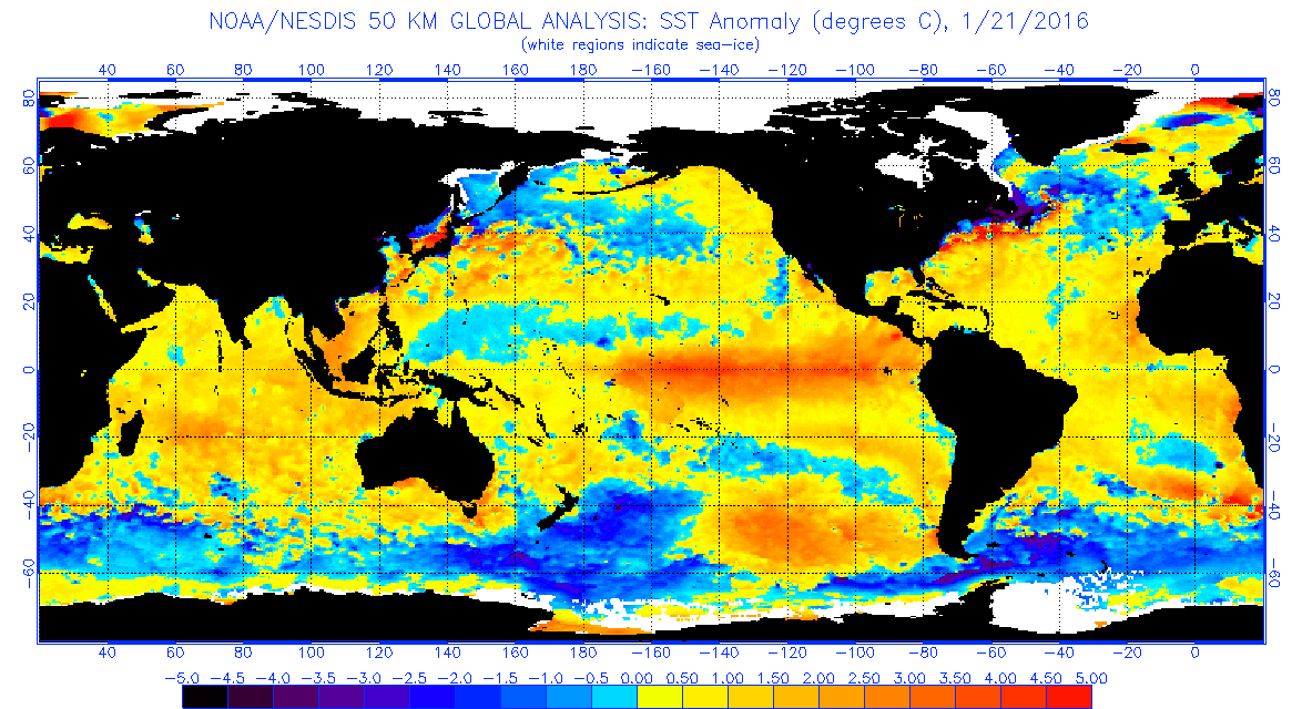
La Nina Developing El Nino Weakens Pacific Sea Surface Temperature Anomalies Mid January 2016
La Nina Developing El Nino Weakens Pacific Sea Surface Temperature Anomalies Mid March 2016
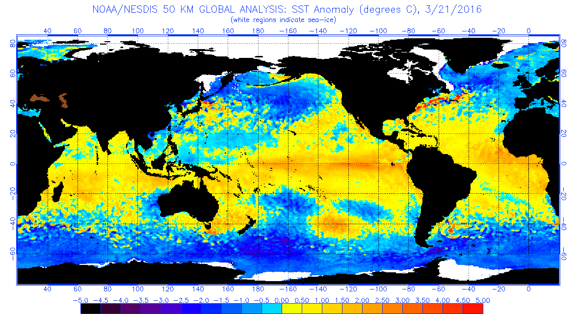
The maps above show the departures from normal of sea surface temperatures across the Northern Hemisphere. The top maps from January 21st 2016, and the bottom is March 21, 2016. First off notice that the extent and magnitude of the above normal temperatures across the Pacific Ocean has decreased considerably. The El Nino went from being up to 5 degrees Celsius above normal to about 2 degrees above. Also the geographic extent of the el nino converage has shrunk. The second big change is across the northern Pacific. There above normal temperatures have all but disappeared and have been replaced by below normal temperatures to almost the entire region north of 35 degrees north. The cold pool in the Western Pacific is increasing and will continue to eat away at the El Nino until is reduced and ultimately reversed. In the Atlantic the waters south of 35 degrees north remain above normal but here too the magnitude has been reduced. Also the cold pool of water surrounding Greenland areas southward has increased substantially.
It appears that we are at the beginning stages of a La Nina Devoloping El Nino Weakens. What does this mean for our weather from a practical nature? Well at first it would be difficult to guess what the day to day implications are until we see some sort of trend develop over a period of weeks or perhaps months. Certainly the persistent ridge that has been in the east is already not been as strong as it was during the record breaking months of November and December though that ridge still has appeared from time to time. La Nina patterns tend to increase hurricane activity in the Atlantic as the large scale upper air westerly winds that tend to shear hurricanes apart will be reduced. Conversely the activity in the Eastern Pacific will be reduced or at least we won’t see the extreme develop of powerful hurricanes there. Sure the odd storm could have the right conditions for brief periods of time, but over the period of the entire season it would point to less activity in the Pacific and more activity in the Atlantic.
La Nina Developing El Nino Weakens GFS Model Temperature Anomalies Monday April 4th 2016
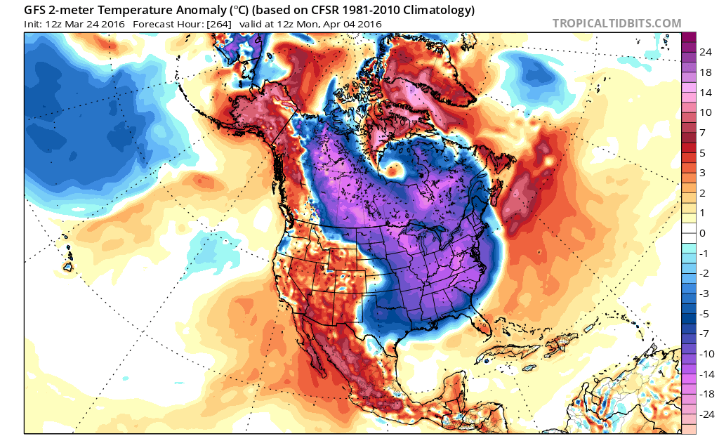
For the current shorter term long range view (next few weeks) it continues to indicate some colder than normal weather is coming for the beginning of April. Today’s GFS model run supports this idea entering the period of day 9 through day 16 (April 3-9) though I would caution here that it doesn’t necessarily mean that it is cold every single day in that stretch. Nor does it mean that we are talking about February or early March cold. Remember the normals are now 10 to 15 degrees above where they were just a month or so ago and they continue to rise. Still for early April this is cold with temperatures 10 degrees or more below normal. This would mean highs in the 40s and lows in the 20s. Yesterday’s JOESTRADAMUS post touched on this and I will have an update later today. The Euro model seems to have a better handle on this and we will post about it this evening once the model run is done.
FiOS1 News Weather Forecast For Long Island
FiOS1 News Weather Forecast For New Jersey
FiOS1 News Weather Forecast For Hudson Valley
NATIONAL WEATHER SERVICE SNOW FORECASTS
LATEST JOESTRADAMUS ON THE LONG RANGE

NOMINATED FOR AN APPY AWARD FOR BEST WEATHER APP!!
Weather App

Don’t be without Meteorologist Joe Cioffi’s weather app. It is really a meteorologist app because you get my forecasts and my analysis and not some automated computer generated forecast based on the GFS model. This is why your app forecast changes every 6 hours. It is model driven with no human input at all. It gives you an icon, a temperature and no insight whatsoever.
It is a complete weather app to suit your forecast needs. All the weather information you need is right on your phone. Android or I-phone, use it to keep track of all the latest weather information and forecasts. This weather app is also free of advertising so you don’t have to worry about security issues with your device. An accurate forecast and no worries that your device is being compromised.
Use it in conjunction with my website and my facebook and twitter and you have complete weather coverage of all the latest weather and the long range outlook. The website has been redone and upgraded. Its easy to use and everything is archived so you can see how well Joe does or doesn’t do when it comes to forecasts and outlooks.
Just click on the google play button or the apple store button on the sidebar for my app which is on My Weather Concierge. Download the app for free. Subscribe to my forecasts on an ad free environment for just 99 cents a month.
Get my forecasts in the palm of your hand for less than the cost of a cup of Joe!
![]()

