Jose Spinning Offshore Clouds Nearby
Jose Spinning Offshore Clouds Nearby
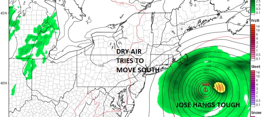
Looking at the satellite loop this evening Tropical Storm Jose is still sitting offshore moving slowly northeast. Just to our west we have a lot of dry air that is fighting to get in here. Some areas today to the west of the coast saw a fair amount of sun while to the east especially Connecticut & Long Island we saw alot of clouds. and something in between right along the coast just west of NYC. Jose is coming to a grinding halt which means clouds will be an issue from time to time over the next few days. Coastal flooding is possible through Friday at least as Jose begins to move to the southwest but all weather models show Jose weakening over the next several days and it may eventually get absorbed by Hurricane Maria as that storm moves northwestward east of the Bahamas and heads for a position well off the Southeast coast.
SATELLITE LOOP

REGIONAL RADAR

Rain bands form Jose are sweeping inland into Southeastern New England but for now those bands are not moving westward which means we should be dry. Clouds to the east tonight and clear to the west with most lows overnight bottoming in the 60s
LOCAL RADAR NEW YORK CITY

LOCAL RADAR PHILADELPHIA


Thursday will be a warm day especially in areas that see a good deal of sunshine. Highs will reach the 80s. Friday as Jose moves southwest it will bring clouds back westward to just inland of the coast. Western New Jersey & the Hudson Valley west of the Hudson River should see some sunshine Friday but to the east of there it could be more clouds. Rain bands could get close to Eastern Long Island but Jose should be weakening at this point. By the time we get to the weekend unless Jose surprises by hanging on longer we should see more sun and few clouds with temperatures in the upper 70s to lower 80s.
Hurricane Maria will probably make for a close call next week as it moves up the coast. The forecast is highly uncertain due to so many factors in play here including Jose which gets involved in weakening the upper flow to the south and an upper air disturbance swinging eastward from Central Canada.
 GET JOE A CIGAR IF YOU LIKE

FiOS1 News Weather Forecast For Long Island
FiOS1 News Weather Forecast For New Jersey
FiOS1 News Weather Forecast For Hudson Valley


