Jose Rain Bands Coming Onshore
Jose Rain Bands Coming Onshore
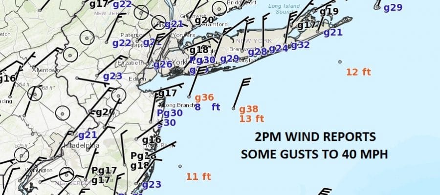
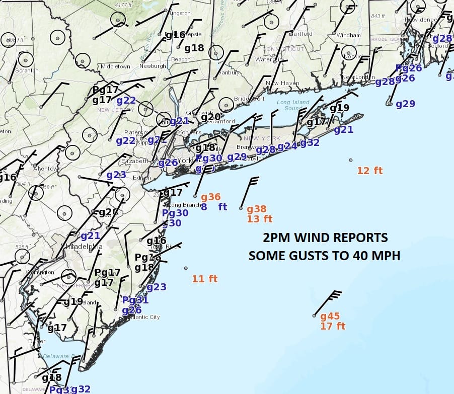
Jose has begun a slow northward drip this afternoon and we have seen bands of rain rotating back westward as evidenced by the satellite and radar. The rains have been mainly confined to the immediate coast and have not survived when the move inland. So far Jose is behaving according to plan with a cloudy breezy day along the coast with occasional bands of rain while inland we have clouds with some breaks of sun. In areas not too far away in the Hudson Valley and Eastern Pennsylvania we are seeing a fair amount of sunshine. Winds along the immediate coast have been gusting 30 to 40 mph at times.
SATELLITE LOOP

REGIONAL RADAR

The rain bands have a lot of space in between them so there are long dry periods in between them as they move westward. We expect these bands to continue into this evening and then gradually shift eastward overnight and Wednesday.
LOCAL RADAR NEW YORK CITY

..HURRICANE JOSE EXPECTED TO PRODUCE DANGEROUS SURF AND RIP
CURRENTS ALONG THE U.S. EAST COAST FOR SEVERAL MORE DAYS…
SUMMARY OF 200 PM EDT…1800 UTC…INFORMATION
———————————————-
LOCATION…36.9N 71.5W
ABOUT 255 MI…415 KM ENE OF CAPE HATTERAS NORTH CAROLINA
ABOUT 310 MI…500 KM SSW OF NANTUCKET MASSACHUSETTS
MAXIMUM SUSTAINED WINDS…75 MPH…120 KM/H
PRESENT MOVEMENT…N OR 10 DEGREES AT 7 MPH…11 KM/H
MINIMUM CENTRAL PRESSURE…976 MB…28.82 INCHES
WATCHES AND WARNINGS
——————–
CHANGES WITH THIS ADVISORY:
None.
SUMMARY OF WATCHES AND WARNINGS IN EFFECT:
A Tropical Storm Warning is in effect for…
* Watch Hill to Hull
* Block Island
* Martha’s Vineyard
* Nantucket
LOCAL RADAR PHILADELPHIA


Weather conditions will begin to improve from west to east on Wednesday. Clouds will linger as you move east. By tomorrow Jose will be somewhere southeast of Montauk and on a slow crawl to the east before stalling and then looping southward. It will remain offshore for several days or more and this will mean coastal flooding issues probably through the end of the week. Coastal Flood Warnings for New Jersey & Western Long Island will continue with tides running 2 feet or more above normal with moderate coastal flooding expected at high tide.

GET JOE A CIGAR IF YOU LIKE
FiOS1 News Weather Forecast For Long Island
FiOS1 News Weather Forecast For New Jersey
FiOS1 News Weather Forecast For Hudson Valley


