Jose Offshore Will Pass East Minimal Impact
Jose Offshore Will Pass East Minimal Impact
Hurricane Jose is sitting southeast of the North Carolina coast by 485 miles with 80 mph winds and moving straight northward at the moment. It appears that Jose will pass far enough east that at worst only some fringe effects will be felt along immediate coastal areas of New Jersey and Eastern Long Island with some gusty winds and higher than normal tides beginning on Monday and lasting at least into Wednesday. With the new moon some coastal flooding is possible though the track of the hurricane offshore will keep the effects down. The new moon high tides won’t peak until late week so there could be some issues into the weekend. jose may wind up lingering for awhile offshore as steering currents are forecast to collapse later this week out in the Atlantic.
SATELLITE LOOP

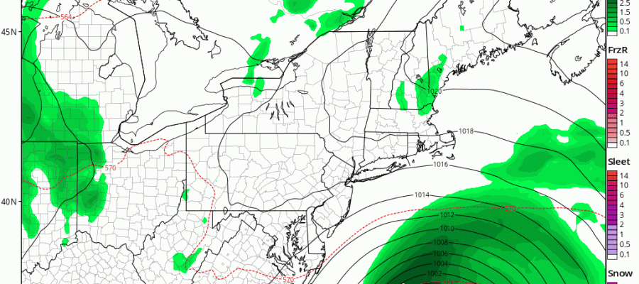
As far as the short term weather is concerned, we are seeing low clouds and fog moving in from off the coast and we will have that to contend with in some areas tonight. The radar shows some isolated downpours and they should wind down as the night progresses.
REGIONAL RADAR

LOCAL RADAR NEW YORK CITY

LOCAL RADAR PHILADELPHIA


Sunday will probably be a repeat of Saturday with warm and somewhat humid conditions with clouds giving way to some breaks of sunshine and temperatures into the 80s. The isolated downpour or two can’t be ruled completely out. Monday we will see some sun with clouds developing later in the day. Highs will be in the 70s. Jose will begin its approach Monday night and make its closest pass on Tuesday.
GFS FORECAST TUESDAY INTO WEDNESDAY CLICK TO ANIMATE
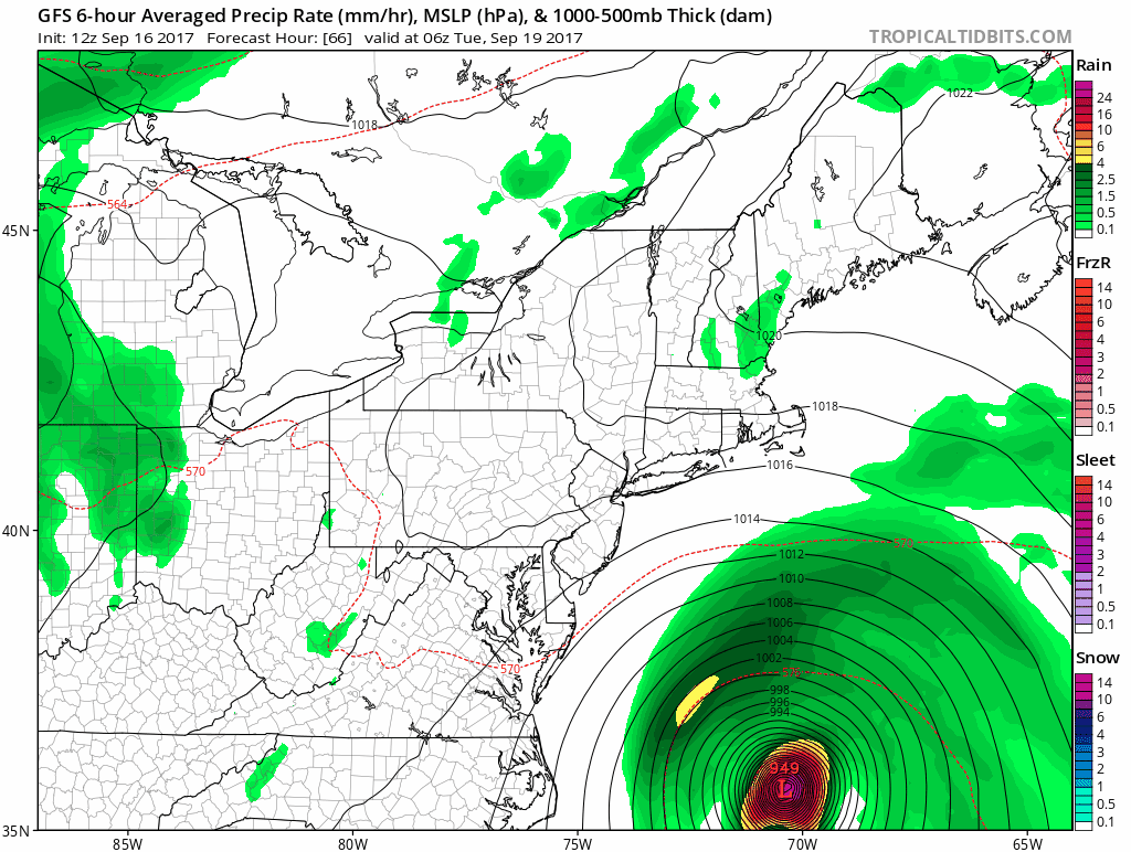
With model trends now decidedly to the east there should not be a problem here. Even though the hurricane is going to grow rather large it will behave much like a winter storm that misses us. Tuesday may not be that bad with clouds along the coast but there will probably be some sunshine inland. Then on Wednesday it looks to be rather sunny and on the warm side. Tuesday’s highs will be in the 70s with the ocean wind and Wednesday it will probably make it back into the 80s.
..JOSE MOVING SLOWLY NORTHWARD WITH 80-MPH WINDS…
…LIFE-THREATENING RIP CURRENTS EXPECTED ALONG THE EAST COAST OF
THE UNITED STATES…
SUMMARY OF 500 PM EDT…2100 UTC…INFORMATION
———————————————-
LOCATION…28.9N 71.9W
ABOUT 485 MI…780 KM SSE OF CAPE HATTERAS NORTH CAROLINA
ABOUT 485 MI…775 KM WSW OF BERMUDA
MAXIMUM SUSTAINED WINDS…80 MPH…130 KM/H
PRESENT MOVEMENT…N OR 360 DEGREES AT 6 MPH…9 KM/H
MINIMUM CENTRAL PRESSURE…973 MB…28.74 INCHES
WATCHES AND WARNINGS
——————–
There are no coastal watches or warnings in effect.
Interests from North Carolina northward to New England on the east
coast of the United States should monitor the progress of this
system. Tropical storm watches may be needed for portions of this
area during the next day or two.
DISCUSSION AND 48-HOUR OUTLOOK
——————————
At 500 PM EDT (2100 UTC), the center of Hurricane Jose was located
near latitude 28.9 North, longitude 71.9 West. Jose is moving
toward the north near 6 mph (9 km/h), and this general motion with
an increase in forward speed is expected through Monday.
Data from an Air Force Reserve Hurricane Hunter aircraft indicate
that maximum sustained winds remain near 80 mph (130 km/h) with
higher gusts. Some fluctuations in intensity are possible over the
next couple of days, but Jose is forecast to remain a hurricane
through Monday.
The aircraft data indicate that Jose has increased in size.
Hurricane-force winds now extend outward up to 45 miles (75 km)
from the center, and tropical-storm-force winds extend outward up to
185 miles (295 km).
The estimated minimum central pressure is 973 mb (28.74 inches).
HAZARDS AFFECTING LAND
———————-
SURF: Swells generated by Jose are affecting Bermuda, the Bahamas,
the northern coasts of Hispaniola and Puerto Rico, and much of the
U.S. east coast. These swells are likely to cause dangerous surf and
rip current conditions for the next several days in these areas.
For more information, please consult products from your local
weather office.
NEXT ADVISORY
————-
Next complete advisory at 1100 PM EDT.
 GET JOE A CIGAR IF YOU LIKE

FiOS1 News Weather Forecast For Long Island
FiOS1 News Weather Forecast For New Jersey
FiOS1 News Weather Forecast For Hudson Valley


