
Jose Churns Offshore Warm Through Weekend
Jose Churns Offshore Warm Through Weekend
…TROPICAL STORM CONDITIONS OCCURRING OVER PORTIONS OF
SOUTHEASTERN NEW ENGLAND…
…HIGH SURF AND RIP CURRENTS EXPECTED TO CONTINUE ON THE EAST
COAST OF THE UNITED STATES…
SUMMARY OF 800 AM AST…1200 UTC…INFORMATION
———————————————-
LOCATION…39.6N 68.1W
ABOUT 150 MI…240 KM SE OF NANTUCKET MASSACHUSETTS
MAXIMUM SUSTAINED WINDS…60 MPH…95 KM/H
PRESENT MOVEMENT…STATIONARY
MINIMUM CENTRAL PRESSURE…982 MB…29.00 INCHES
SUMMARY OF WATCHES AND WARNINGS IN EFFECT:
A Tropical Storm Warning is in effect for…
* Woods Hole to Sagamore Beach, including Cape Cod
* Block Island
* Martha’s Vineyard
* Nantucket

Jose has come to a grinding half this morning about 350 miles east of the New Jersey coast. Southeastern New England was getting clipped by tropical storm conditions but the bands fo rain have shifted a bit to the south and it appears that no one is rain at the moment. The proximity to the coast will mean cloud issues as they rotate back westward. Areas to the the west of the coastal will see more in the way of sunshine today with temperatures reaching the 80s while areas that keep getting waves of clouds coming in from the east like Connecticut & Long Island will be in the 70s.
SATELLITE LOOP

REGIONAL RADAR

Radars both regionally and locally show not too much activity except the western edge of the rain bands from Jose do show up on the radar well to the east. No showers or downpours are forecast for the next several days as other than clouds we should should minimal issues from Jose. There is a slight chance that one or two of the rain bands could get to Eastern Long Island on Friday but as long as Jose stalls out and weakens where it is now, there shouldn’t be any issues. This means that Saturday and Sunday we will see sunshine both days with temperatures in the upper 70s to lower 80s.
LOCAL RADAR NEW YORK CITY

LOCAL RADAR PHILADELPHIA


As far as next week is concerned we will have high pressure aloft and Hurricane Maria somewhere along the East Coast offshore. Right now it appears that odds are growing for Maria to remain an offshore storm. Odds are also growing that we may finally see a change in the weather pattern with cooler air arriving late next week. Warm summery weather continues until Thursday or Friday just in time for the arrival of October!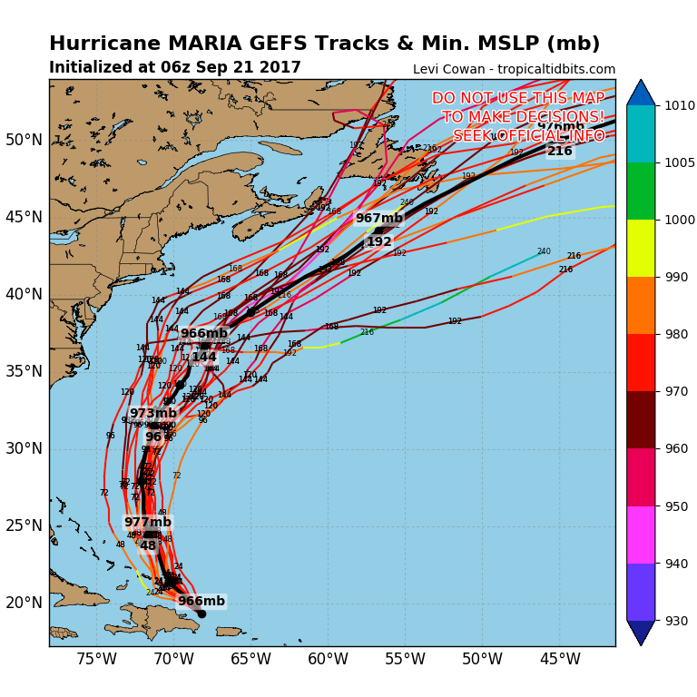
As far as Maria is concerned the odds are growing that Maria will be an out to sea storm in the long range. We will wait a bit before nailing the door shut on this one for us. It will make a close enough pass to keep the ocean churned up through much of next week.We will have more on Maria later today.
FiOS1 News Weather Forecast For Long Island
FiOS1 News Weather Forecast For New Jersey
FiOS1 News Weather Forecast For Hudson Valley


