JOESTRADAMUS Week Ahead Forecast
JOESTRADAMUS Week Ahead Forecast
Slow Improvement Sunday
One More Disturbance Moves Through Sunday
Another Shower or Two Possible
The atmosphere is in slow motion and it is taking three days to get all the upper air energy out of the way. Saturday we were deep in a marine layer that kept temperatures in the 60s and 70s. Now we are finally getting the last disturbance to move through Sunday morning. There will be some clouds with this when it goes by and another shower or two is possible.
JOESTRADAMUS WEEK AHEAD FORECAST
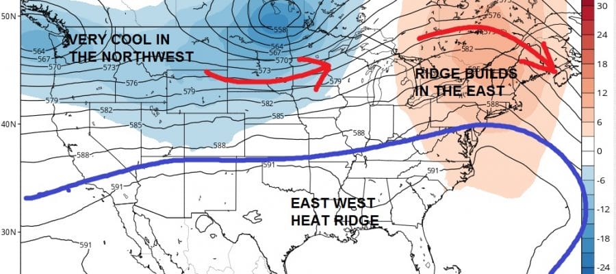
NAM MODEL UPPER AIR SUNDAY MORNING

Once it goes by around midday we should see partly sunny skies develop as winds begin to turn more northwest and we begin to dry out with lower humidity. This should lead us to some nice weather for Monday with sunshine and highs in the upper 70s and lower 80s. Tuesday looks good with sunshine and temperatures back in the 80s everywhere.
JOESTRADAMUS WEEK AHEAD FORECAST
NAM MODEL UPPER AIR WEDNESDAY
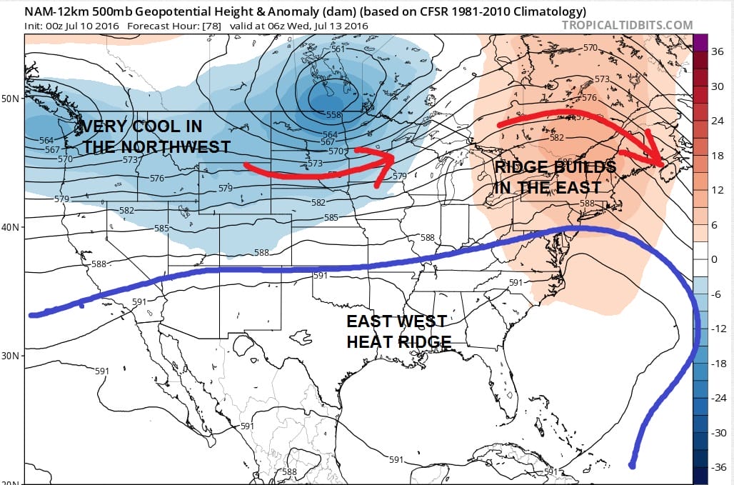
As we go through the week we see the westerly winds in the jet stream pulling up somewhat and with troughing in the west, particularly in the northwest, it is causing the ridge to pop up a bit in the eastern United States. This will probably mean a boost in temperatures Wednesday and Thursday up toward 90 or lower 90s. However that northern jet will be active enough and another front will probably come through toward the end of the week. Longer term as we move through mid July and beyond, it is hard for me to see long lasting heat as long as that northern jet stream remains close and active. Models have occasionally shown heat building northward only to back off and I think this may be the case yet again.
LATEST WEATHER VIDEO ON THE LONG RANGE PLUS A LOOK AT THE TROPICAL ATLANTIC
[brid video=”54077″ player=”6390″ title=”JOESTRADAMUS Long Range Forecast Into Late July”]

MENTION JOE CIOFFI AND GET A 5% DISCOUNT
FiOS1 News Weather Forecast For Long Island
FiOS1 News Weather Forecast For New Jersey
FiOS1 News Weather Forecast For Hudson Valley
NATIONAL WEATHER SERVICE SNOW FORECASTS
LATEST JOESTRADAMUS ON THE LONG RANGE
Weather App

Don’t be without Meteorologist Joe Cioffi’s weather app. It is really a meteorologist app because you get my forecasts and my analysis and not some automated computer generated forecast based on the GFS model. This is why your app forecast changes every 6 hours. It is model driven with no human input at all. It gives you an icon, a temperature and no insight whatsoever.
It is a complete weather app to suit your forecast needs. All the weather information you need is right on your phone. Android or I-phone, use it to keep track of all the latest weather information and forecasts. This weather app is also free of advertising so you don’t have to worry about security issues with your device. An accurate forecast and no worries that your device is being compromised.
Use it in conjunction with my website and my facebook and twitter and you have complete weather coverage of all the latest weather and the long range outlook. The website has been redone and upgraded. Its easy to use and everything is archived so you can see how well Joe does or doesn’t do when it comes to forecasts and outlooks.
Just click on the google play button or the apple store button on the sidebar for my app which is on My Weather Concierge. Download the app for free. Subscribe to my forecasts on an ad free environment for just 99 cents a month.
Get my forecasts in the palm of your hand for less than the cost of a cup of Joe!

