Joestradamus Takes Long Range View

Joestradamus Takes Long Range View
Getting one’s head around the long range has always been a big challenge for JOESTRADAMUS. He is, after all, more of short range kind of guy. At this point he sees out there what seems to be an army of snow weenies in utter despair. Apparently the latest round of long range pontificators has proclaimed everything from winter is over to winter is over for the next 4 weeks to all sorts of other possibilities. It is at this point and after careful examination of today’s version of psychotic weather models that one needs to take a step back and look at what is going on.
First off a couple of reminders. First off so far for the month of December most reporting stations in the area are running at or slightly below normal (NYC -1.0) through today. Snowfall for the month is now 3.2 inches which if you divide the snowfall evenly over the course of the month we are about average. More than likely looking ahead at the next 12 days the numbers will probably average slightly above normal so in the end the month might finish even or a little bit above average. As far as snow goes, given what is being shown it doesn’t seem like anything of consequence is going to happen through the end of the month unless there is something upstream that we can’t see at the moment. In the end we would have had a typical December and certainly nothing like the record warm month of December 2015 with no snow measured and December 2014 which was 3 degrees above average with an inch of snow.
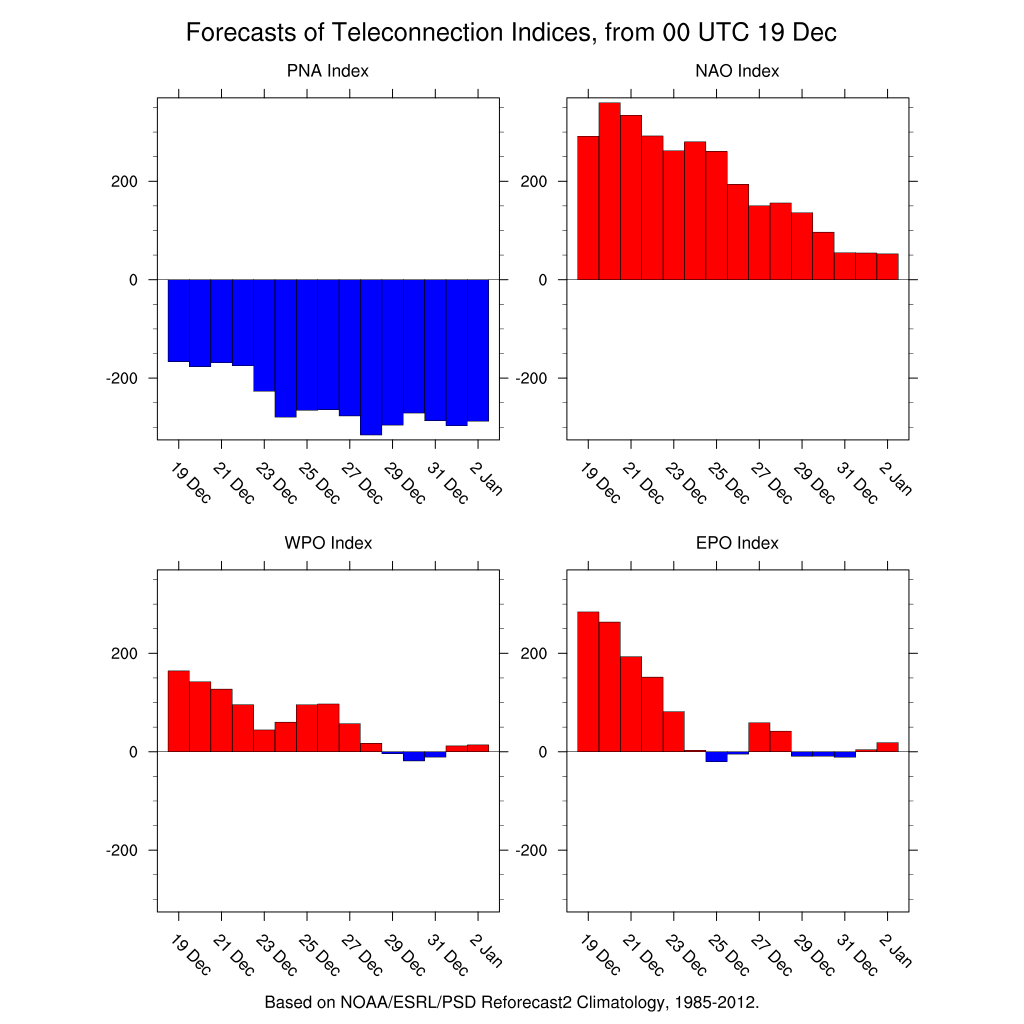
Today’s view of the teleconnections don’t tell us too much. The Eastern Pacific Oscillation is forecast to trend to neutral to slightly negative beginning this coming weekend and into the New Year. The North Atlantic Oscillation or NAO trends from super positive to positive and then toward neutral by the end of the period. The Pacific North America pattern index remains strongly negative right through the period and shows no sign of breaking this negative look anytime soon. The neutral EPO probably prevents us from getting super warm. I usually don’t look at the NAO as a cold indicator as I would rather have a negative East Pacific Oscillation with a positive NAO rather than the other way around.
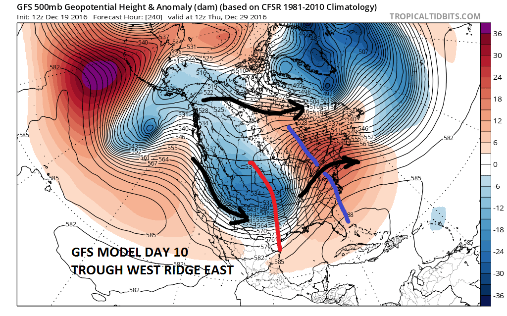
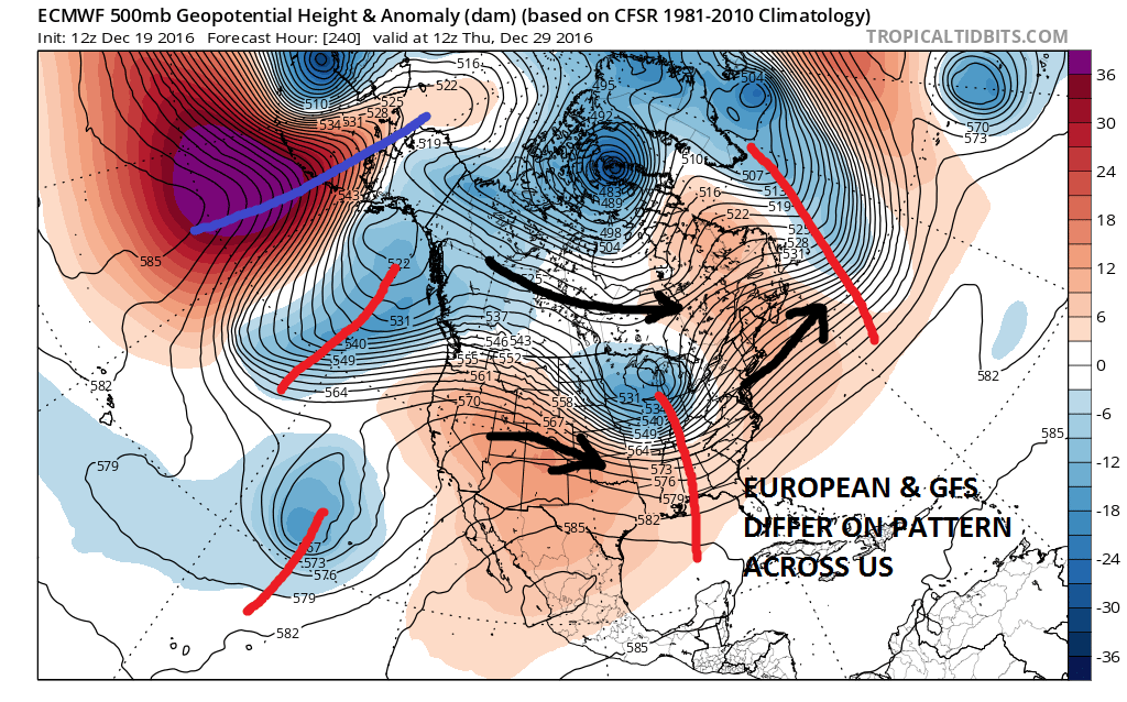
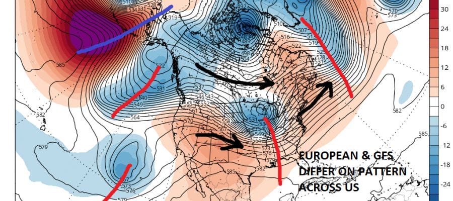
The European and GFS seem to differ a bit around day 10 as the European is not as bullish on the ridge in the east idea. Its not that it isn’t there. It is just less bullish than the GFS. When you look at the ensembles they all seem to line up with the idea of a ridge in the east. I think the best approach here is to expect it to be milder than average. I don’t think it will be exceptionally milder than average but we shall see where it goes.
The bigger question in my view is whether the pattern of trough in the west ridge in the east is something that is going to lock in for the winter or is it transitory. Winter weather lovers should be concerned because this is usually the “lock in” period that is typical in most (but not all winters) where the pattern switches in the end of December and holds for at least 4 to 6 weeks. This was not the case in 2014-2015 where we had a major pattern flip in mid January that brought a strong cold pattern that held into late March. My opinion on this is we just don’t know. Some of the same forecasters who were excessively bullish on a snowy cold December are now probably excessively bearish for January and beyond. Or perhaps they are now pushing a pattern realignment back into mid or late January. The point is we just don’t know. The weak La Nina would suggest that there should be a flip back but as I have pointed out many times, there are many factors to consider and not just 1. Perhaps this is a winter where we see volatile pattern changes every couple of weeks. Or maybe we should just consider that psychotic models in the long range are just that and perhaps it might be better to approach this differently and just stick to what is in front of you for the next week or so and not lose sleep over the long term. It will be what it will be regardless of what forecasters are saying. My own personal guess (and that what it is) is that the NAO will trend to neutral in the first 2 weeks of January and the EPO will go slightly negative which will open the door to colder air coming into the east with some frequency. We will probably see some chances for snow going forward in all this. There are clues that this should happen but those clues can quickly disappear from run to run. Bottom line we do what we always do. Watch, wait, and forecast.
MANY THANKS TO TROPICAL TIDBITS FOR THE WONDERFUL USE OF THE MAPS
SNOW REMOVAL COMPANIES FOR YOUR WINTER NEEDS
LONG ISLAND ROCKLAND COUNTY Connecticut

![]()


JOHNSTOWN PA
COLOSIMO LAWNCARE

FiOS1 News Weather Forecast For Long Island
FiOS1 News Weather Forecast For New Jersey
FiOS1 News Weather Forecast For Hudson Valley
NATIONAL WEATHER SERVICE SNOW FORECASTS
LATEST JOESTRADAMUS ON THE LONG RANGE
Weather App

Don’t be without Meteorologist Joe Cioffi’s weather app. It is really a meteorologist app because you get my forecasts and my analysis and not some automated computer generated forecast based on the GFS model. This is why your app forecast changes every 6 hours. It is model driven with no human input at all. It gives you an icon, a temperature and no insight whatsoever.
It is a complete weather app to suit your forecast needs. All the weather information you need is right on your phone. Android or I-phone, use it to keep track of all the latest weather information and forecasts. This weather app is also free of advertising so you don’t have to worry about security issues with your device. An accurate forecast and no worries that your device is being compromised.
Use it in conjunction with my website and my facebook and twitter and you have complete weather coverage of all the latest weather and the long range outlook. The website has been redone and upgraded. Its easy to use and everything is archived so you can see how well Joe does or doesn’t do when it comes to forecasts and outlooks.
Just click on the google play button or the apple store button on the sidebar for my app which is on My Weather Concierge. Download the app for free. Subscribe to my forecasts on an ad free environment for just 99 cents a month.
Get my forecasts in the palm of your hand for less than the cost of a cup of Joe!
![]()
