
JOESTRADAMUS: Storm Signals For Next Week
We continue to watch the evolution of the longer range pattern and all three models are sending various storm signals though of course this far out they all vary on size, strength, cold air, warm air and everything else. However all three share the common idea that a strong system will be coming into the Pacific and moving across the United States early next week (November 29th-Dec 3) so we will have something to watch as we move through Thanksgiving week. The weather forecasting models have been on this idea for days now.
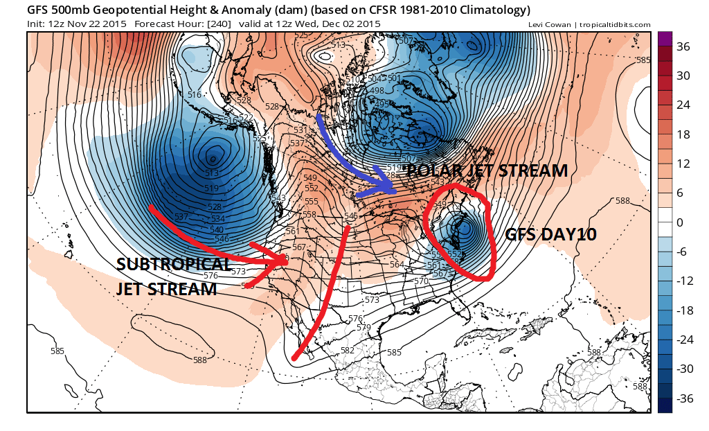
The look on all three models is similar in a broad sense but as usual they all have their own biases. The subtropical jet is clear on all three weather forecasting models. The polar jet flow is also clear on all 3 as well. What is not clear is the depth of the systems in both streams and how they interact with each other. The polar jet in 2 of the 3 models is north of the Canadian border which would argue that the amount of cold air that will be around will be limited. The Canadian at the bottom has the polar jet a little further south than the others.
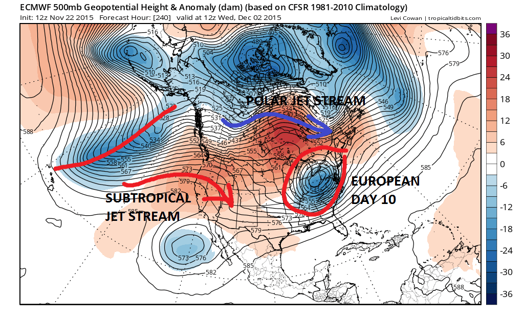 The European forecasting model on this run seems to have the more impressive upper air system aloft approaching the east coast. The Canadian is the slowest of the 3 models and seems to me to be too slow. One clue from the late afternoon GFS model that the European timing might be better is that it is already 6 hours slower than the previous run in terms of position.

How this evolves at the surface is another question. The gfs is not all that deep with the low that comes out of the southwest and runs west of the Appalachians and has a weak look overall. The European with more dynamics and a strong cold upper air system might open the door to snow for somebody at some point of the life cycle of this system and areas well west of the coast (inland Pennsylvania and westward) with some “do it yourself” cold air. This is just up in the air speculation on my part at this point. The takeaways from today’s run in my view would be simply that some sort of weather system will be impacting the east next week. I couldn’t even begin to say at this point what exactly we would be dealing with as the models will continue to remold and change over the next several days.
One of the important things to remember about a split flow like this is that whichever jet dominates will be key to outcome. If the northern polar jet were suddenly too strong it could suppress everything south and keep things weak. The streams remain separate except to some degree for the Canadian which has a more “semi-phased” look. The European has a very strong feature in the southern Jet which probably could make things interesting all on its own.
Remember folks this is late November/Early December and the number of snow storms that occur this time of year in the east is small even in the most ideal of patterns. Nothing that is going on now in the atmosphere gives any kind of super long term indication. It may offer clues however you won’t know that in hindsight. Remember last December? It wasn’t exactly a gangbusters winter month for much of the East or Midwest for that matter and that followed a rather cold and snowy November (Epic Western New York lake effect, Pre Thanksgiving snowstorm for inland areas of the northeast). There is no need for snow lovers to tie the noose around their necks and toss the other end into the nearest ceiling fan. In fact there is no need even to take the rope out of storage.