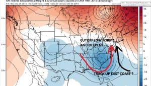
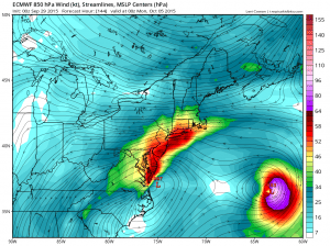
JOESTRADAMUS thought this would be a good time to basically go over a few things regarding Tropical Storm Joaquin and what he is thinking about this overall and also to clarify what you may be seeing elsewhere.
First off regardless of whether Tropical Storm Joaquin remains a tropical storm or strengthens to something further is a big question. Models that are forecasting this to become a category 3 hurricane are the same models that forecasted Erika, Ida, and a few others to do the same thing. We know how that ended up. In a season where shear has been everywhere and has ripped every storm apart, it seems to me that to bet on deepening to a category 3 is not a smart bet unless someone is giving you long odds. Still I think Joaquin

The visible satellite loop clearly shows the circulation center on the western edge of the convection with most of the thunderstorms east and south of the center. It looks like some thunderstorms are trying to wrap around but the center is still exposed. The clouds to the northeast of Tropical Storm Joaquin are from the western side of an upper low that is producing northerly shear. This shear is forecast to relax somewhat as the upper low moves east and Tropical Storm Joaquin inches toward the west. It has been my experience that models tend to over relax shear and this has been the case with virtually every storm this season. Models show relaxed shearing conditions which wind up not happening. Perhaps this is going to be the first time. I happen to believe the shearing is going to relax somewhat or at least enough to cause Joaquin to strengthen perhaps to 55 or 60 knots in time. Beyond that I think a lot has to happen aloft to get this to a hurricane let alone a category three.
But let us lay all this aside for one minute. I think that regardless of what Joaquin does or even if it doesn’t survive at all..there are still extra tropical events taking place that will create noreaster conditions here beginning late Friday and lasting into the weekend. Let me illustrate something here with one of the models that has not done well this season. The GFDL has been awful with regards to intensity. It has predicted 11 out of the last 0 major hurricanes. Im not counting Danny since it got to major status probably for 5 minutes. 
This is one models view. The GFDL model takes a category 3 hurricane northeastward from the Bahamas to west of Bermuda and then swings it back northwestward from there. This is a category 3 hurricane being shown. Lets just suppose this is correct (and I dont believe it is). We will still experience noreaster conditions here with the big high to the northeast and a strong easterly fetch. The problem with these models and all of them is that they seem to show some sort of renegade development which then impacts the upper air pattern as it becomes a deeper system. My view is that this will be a less deep more shallow system and therefore more directly subject to the flow of the upper air along the east coast as was show last night.
Or perhaps the upper feature cuts off in the south so vigoursly you have this going well out to the east like the European showed last night but you still have a coastal low developing in response to all the dynamics resulting in noreaster conditions anyway. It should be noted that a number of the European ensemble member models have a north and then a northwest track into the Mid Atlantic States.
Here is the bottom line. Pay attention to what I write and how I write it. Im very deliberate and trying to show you my thinking on all this. Right now worrying about a hurricane that hasn’t even gotten past mid tropical storms strength is rather silly given the season we have had. I think that first things first we get a solid 1 to 3 inches of rain tonight. The a break later tomorrow with perhaps another round of rain at some point later Thursday into Friday…and then lets sit back and wait and see just what comes of all this. Again I think regardless of Tropical Storm Joaquin and its ultimate destiny, we are still going to have to deal with wind rain and coastal flooding possibilities from Thursday and into the weekend.
Also one last thing. It is already getting out of hand and I would love to be able to zip code forecast but I can’t and I’m not going to. So if you have specific questions please make sure you read the posts first before asking because your answer may be in there. And please learn to read maps. If you are on a weather page you need to understand basic geography . I get that the meteorology can be a bit tough sometimes but I will try to make it understandable for everyone.
For specific forecasts please download my weather app and subscribe to my forecasts. The app is free and a subscription is just 99 cents a month. The app is free of advertising and there are no security or tracking issues.


