
JOESTRADAMUS: Long Range Pattern Change Imminent
It is now clear to JOESTRADAMUS that a wholesale pattern change is underway and we are heading for a wintry beginning to 2016. The first winter storm threat for the northeast looms for early next week and this is with the pattern still in December 2015 mode. However this system begins the process of altering the entire pattern in the east from strong ridge to deep trough.
We can see how the pattern transitions from the one we have been in since mid October to the new one which is going to be evolving in the next 2 weeks. Here is the current upper air look which pretty much sums up the general pattern we have been in for the last 9 weeks.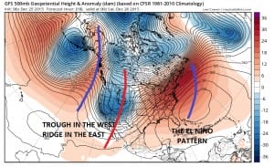
As we move through next week and into New Years day, the profile changes from trough in the west ridge in the east to trough developing in the east and a ridge in the west. Also the flow from Northern Canada begins to open up which will begin the delivery of colder air. This should at least take temperatures down to seasonal in the east.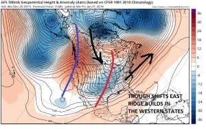
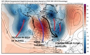
Now from here the transition continues and sets up by day 10 with a strong polar flow from northern Canada. I have been pointing out in my videos and posts over the last number of days that this pattern is potentially dangerous for a number of reasons. The strong northwest flow like this that dives deep into the east opens the door for storm developement if (and its a big if) there is something in the flow that is strong enough to get something going. We will be watching this carefully over the next few weeks.
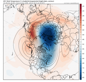
Longer term into January we will have to consider if this is a permanent change or a temporary one and that will depend on what happens with the el nino, the blocking at the poles and other factors. With regards to el nino, it has peaked and has begun to decline. I have argued that the key would be whether we have reached a tipping point. Judging from the latest model runs we have appeared to have reached the tipping point here. Also note the map below which is a look at the stratosphere or the very top of the atomosphere. The polar vortex which has been strong and locked up north is weakening and splitting. This is an important developement as if this is correct then blocking will be setting up across the polar regions displacing cold air southward. The split is forecast to occur in the the next 2 weeks which then lags so this would argue for a very wintry pattern here in the east from Mid January onward. This is something that JOESTRADAMUS is going to be watching closely on future JOESTRADAMUS posts.
WINTER STORM THREAT INCREASES FOR THE NORTHEAST
Weather App

Winter is coming. Don’t be without Meteorologist Joe Cioffi’s weather app. It is a complete weather app to suit your forecast needs. All the weather information you need is right on your phone. Android or I-phone, use it to keep track of all the latest weather information and forecasts. This weather app is also free of advertising so you don’t have to worry about security issues with your device. An accurate forecast and no worries that your device is being compromised.
Use it in conjunction with my website and my facebook and twitterand you have complete weather coverage of all the latest weather and the long range outlook. The website has been redone and upgraded. Its easy to use and everything is archived so you can see how well Joe does or doesn’t do when it comes to forecasts and outlooks.
Just click on the google play button or the apple store button on the sidebar for my app which is onMy Weather Concierge. Download the app for free. Subscribe to my forecasts on an ad free environment for just 99 cents a month.
Get my forecasts in the palm of your hand for less than the cost of a cup of Joe!
