
Joestradamus is always nervous. But a few things are going on tonight that gives me a little pause. I still believe the European will be correct in the end but I’m looking at a few things tonight that make you scratch your head. I’m just essentially thinking out loud here.
Hurricane Joaquin is at category 4 with winds at 130 mph. The eye has clouded over and it appears the rapid deepening that took the pressure from 1002 mb 2 days ago to 930 mb has stopped and that the hurricane may be undergoing an eyewall replacement cycle. Major hurricanes do this as it is sort of a way of recharging in a sense. The last recon shows that the pressure has risen 5 millibars to 935 mb. The recon position at 8pm was 22.9N 74.5 W and was the position used on the 8pm advisory.

JOAQUIN OVER THE CENTRAL BAHAMAS...
...HURRICANE CONDITIONS TO CONTINUE OVER THE CENTRAL BAHAMAS THROUGH
EARLY FRIDAY...


SUMMARY OF 1100 PM EDT...0300 UTC...INFORMATION
-----------------------------------------------
LOCATION...22.9N 74.6W
ABOUT 20 MI...35 KM ESE OF CLARENCE TOWN LONG ISLAND BAHAMAS
ABOUT 75 MI...125 KM S OF SAN SALVADOR
MAXIMUM SUSTAINED WINDS...130 MPH...215 KM/H
PRESENT MOVEMENT...W OR 260 DEGREES AT 3 MPH...6 KM/H
MINIMUM CENTRAL PRESSURE...935 MB...27.61 INCHES

The wide satellite loop is very interesting. You can see the upper low in Tennessee is driving the flow up the Atlantic seaboard from Florida up the coast. Lots of rain is coming up from off the ocean into our area tonight doing us some good as far as the drought is concerned. It is hard to believe that the alley way that exists right now for the hurricane to move up the coast is going to soon close off and instead act as a kicker and force Hurricane Joaquim to the northeast but that is what they are telling us.


Often times hurricanes slow down before making the turn and perhaps this is where we are at in the lifespan of Hurricane Joaquin. Tonight’s nam at 42 hours has the hurricane moving north northwest parallel to the Florida coast which is completly the opposite of what the European did today. The NAM still looks like it wants to take aim for the South Carolina or North Carolina coast.
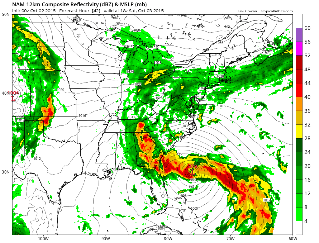

I’m still confident that the global models will continue to lock in on an offshore track. The nam is the weakest of all the models in these sorts of situations. I can’t really sea what’s going on with the a tropical system of this kind of depth. These mind battles are the sorts of battles that forecasters always put themselves through when waiting for something that is forecast to happen to actually happen! We should know soon enough.
Joestradamus breaks down all the major models including the European in his afternoon discussion. The European model has led the way to the eastward shift.
Be sure to download my weather app and subscribe to my forecasts. The app is free and the subscription is though the 99 cents a month. The app is free of advertisement and there are no tracking or security issues.