
Irma Update Labor Day Improvement
Irma Update Labor Day Improvement
It has not exactly been a great second day of the hoilday weekend weather wise. The remnants of Harvey have played through overnight and this morning. There are a few more bands of showers on the radars below showing up in some areas however for most of you the rain is done. The sun has attempted to poke through the clouds in some spots with limited if any success. There is the risk of one or two more scattered showers otherwise it will remain rather dreary in most areas for the remainder of the afternoon with temperatures struggling in the upper 60s to mid 70s.
SATELLITE LOOP

REGIONAL RADAR

LOCAL RADAR NEW YORK CITY

LOCAL RADAR PHILADELPHIA


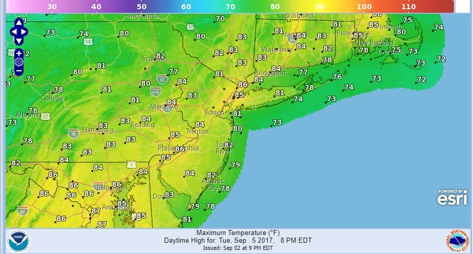
Skies should clear out tonight so if you have evening plans unless there is a stray shower you should be fine. Most lows will be in the 60s. Then Monday Labor Day looks good with sunshine. Should be a good beach day or for one last summer party. Temperatures will be warm with highs back into the 80s. Tuesday looks very warm with sunshine and highs in the mid to upper 80s. No rain is forecast Monday or Tuesday.
Wednesday brings the next cold front with the threat for showers. That front might be slow to move through but we should see some improvement on Thursday. Then we focus on the weekend which is likely to have Hurricane Irma out there somewhere and probably near the Bahamas with sights set on the US east coast though where exactly remains in question. Also in question is whether an alley way opens up for an out to sea track. Latest weather models suggest that the alley way will be closing rapidly and that Irma will miss that opportunity. Right now the threat for the Leeward Islands is increasing as Irma continues on a west southwest course. It took a little wobble more to the west late this morning but the latest satellite loop shows that the southwest course has resumed. This is critical to the Northern Leewards and Virgin Islands as the southwest course brings the hurricane further south and puts them at greater risk.

…CATEGORY THREE HURRICANE IRMA MOVING WEST-SOUTHWESTWARD…
…INTERESTS IN THE LEEWARD ISLANDS SHOULD MONITOR THE PROGRESS
OF IRMA…
SUMMARY OF 1100 AM AST…1500 UTC…INFORMATION
———————————————–
LOCATION…17.7N 48.4W
ABOUT 885 MI…1420 KM E OF THE LEEWARD ISLANDS
MAXIMUM SUSTAINED WINDS…115 MPH…185 KM/H
PRESENT MOVEMENT…WSW OR 255 DEGREES AT 14 MPH…22 KM/H
MINIMUM CENTRAL PRESSURE…969 MB…28.62 INCHES
WATCHES AND WARNINGS
——————–
There are no coastal watches or warnings in effect.
Interests in the Leeward Islands should monitor the progress of
Irma. Hurricane and Tropical Storm Watches will likely be required
for portions of these islands later today or tonight.
DISCUSSION AND 48-HOUR OUTLOOK
——————————
At 1100 AM AST (1500 UTC), the center of Hurricane Irma was located
near latitude 17.7 North, longitude 48.4 West. Irma is moving toward
the west-southwest near 14 mph (22 km/h) and this course at a
slightly slower forward speed is expected through tonight. A turn
toward the west is forecast on Monday.
Maximum sustained winds are near 115 mph (185 km/h) with higher
gusts. Irma is a category 3 hurricane on the Saffir-Simpson
Hurricane Wind Scale. Some strengthening is forecast during the
next 48 hours.
Hurricane-force winds extend outward up to 25 miles (35 km) from the
center and tropical-storm-force winds extend outward up to 80 miles
(130 km).
The estimated minimum central pressure is 969 mb (28.62 inches).
HAZARDS AFFECTING LAND
———————-
None
 GET JOE A CIGAR IF YOU LIKE

FiOS1 News Weather Forecast For Long Island
FiOS1 News Weather Forecast For New Jersey
FiOS1 News Weather Forecast For Hudson Valley


