Irma Major Hurricane 115 MPH Category 3
Irma Major Hurricane 115 MPH Category 3

We have the seasons second major hurricane as Irma which just 36 hours ago was barely a depression continues to strengthen rapidly. Maximum sustained winds are now 115 mph making Irma a category 3 hurricane.
…IRMA BECOMES A CATEGORY 3 HURRICANE OVER THE EASTERN ATLANTIC…
SUMMARY OF 500 PM AST…2100 UTC…INFORMATION
———————————————-
LOCATION…17.3N 34.8W
ABOUT 720 MI…1160 KM W OF THE CABO VERDE ISLANDS
ABOUT 1780 MI…2865 KM E OF THE LEEWARD ISLANDS
MAXIMUM SUSTAINED WINDS…115 MPH…185 KM/H
PRESENT MOVEMENT…WNW OR 290 DEGREES AT 12 MPH…19 KM/H
MINIMUM CENTRAL PRESSURE…967 MB…28.56 INCHES
WATCHES AND WARNINGS
——————–
There are no coastal watches or warnings in effect.
DISCUSSION AND 48-HOUR OUTLOOK
——————————
At 500 PM AST (2100 UTC), the center of Hurricane Irma was located
near latitude 17.3 North, longitude 34.8 West. Irma is moving
toward the west-northwest near 12 mph (19 km/h). This motion is
expected to continue today, followed by a westward turn on Saturday,
and a west-southwestward motion by Sunday.
Maximum sustained winds have increased to near 115 mph (185 km/h)
with higher gusts. Irma is a category 3 hurricane on the
Saffir-Simpson Hurricane Wind Scale. Fluctuations in strength,
both up and down, are possible, but Irma is expected to remain a
powerful hurricane for several days.
Hurricane-force winds extend outward up to 15 miles (30 km) from the
center and tropical-storm-force winds extend outward up to 80 miles
(130 km).
The estimated minimum central pressure is 967 mb (28.56 inches).
HAZARDS AFFECTING LAND
———————-
None

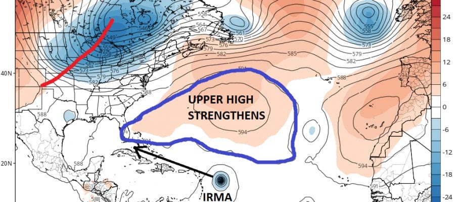
Irma is very large and very impressive. In spite of a strong upper low to the northwest of the storm, the wind conditions aloft remain favorable for strengthening. While water temperatures a moderately warm to the west of the hurricane which could slow the strengthening down, it will be back over very warm water early next week. Irma at the very least will become a category 4 hurricane at some point.

Weather models this afternoon remain unchanged from the last 3 major cycle runs. While the GFS has been a bit scattered with its views, the European has remained remarkably consistent with taking a more southern track. This could put the Northern Leeward Islands at risk early next week. Weather models move Irma more westerly over the weekend and then toward the southwest beginning on Sunday.

As far as the European model is concerned the Atlantic ridge is very strong and certainly stronger than the other models. The European model also builds the western flank of the ridge along the East Coast in the longer term,

The GFS is holding firm on its idea of creating enough of a weakness for a northwest course to develop and having Irma passing well north of the islands.
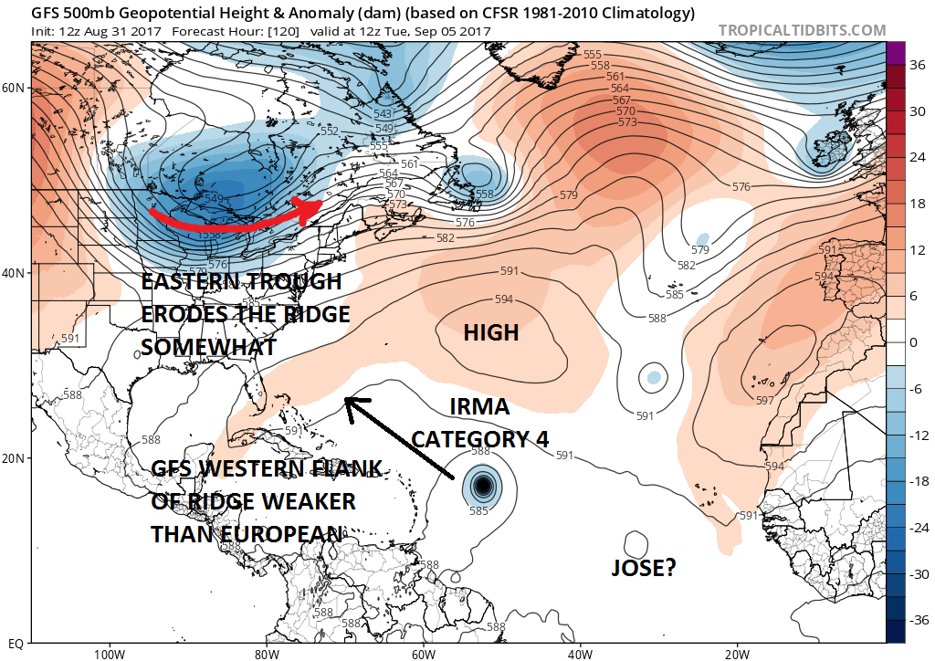
None of this is going to be resolved anytime soon in my view. Until we get a clear picture of which model has the better profile in the Atlantic, we will continue to struggle with model runs and their outcomes. Beyond 120 hours it becomes futile to focus on where models take these storms. Except for the European which remains steadfast, each run of the GFS is going to bring a landfall to a different place. I would suggest you dismiss that completely for now since it really is a waste of time and energy. Every run on the GFS will pick a different target. All options remain open though I must admit the European’s consistency is leading me to lean in that models direction right now. Both models develop a wave behind Irma into a tropical storm or hurricane early next week.
With regards to the western Gulf of Mexico, pressures remain low there into next week and some models still try to develop something in the Southwest Gulf. For now we will just sit back and watch it all play out over the next few days.
MANY THANKS TO TROPICAL TIDBITS FOR THE WONDERFUL USE OF THE MAPS
Weather App

Don’t be without Meteorologist Joe Cioffi’s weather app. It is really a meteorologist app because you get my forecasts and my analysis and not some automated computer generated forecast based on the GFS model. This is why your app forecast changes every 6 hours. It is model driven with no human input at all. It gives you an icon, a temperature and no insight whatsoever.
It is a complete weather app to suit your forecast needs. All the weather information you need is right on your phone. Android or I-phone, use it to keep track of all the latest weather information and forecasts. This weather app is also free of advertising so you don’t have to worry about security issues with your device. An accurate forecast and no worries that your device is being compromised.
Use it in conjunction with my website and my facebook and twitter and you have complete weather coverage of all the latest weather and the long range outlook. The website has been redone and upgraded. Its easy to use and everything is archived so you can see how well Joe does or doesn’t do when it comes to forecasts and outlooks.
Just click on the google play button or the apple store button on the sidebar for my app which is on My Weather Concierge. Download the app for free. Subscribe to my forecasts on an ad free environment for just 99 cents a month.
Get my forecasts in the palm of your hand for less than the cost of a cup of Joe!