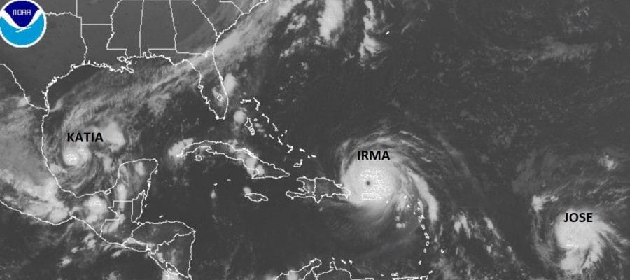
Irma Jose Katia 3 Hurricanes First Time Since 2010
Irma Jose Katia 3 Hurricanes First Time Since 2010

We will start of course with Irma which buzz sawed its way through the Leeward & Virgin Islands as a category 5 and wiped many of the islands with tremendous damage in Barbuda, Antigua, St Martin & St Thomas. Irma is now moving away from Puerto Rico and is heading next to the Bahamas.
…EYE OF CATEGORY 5 HURRICANE IRMA CONTINUES PASSING JUST NORTH OF
PUERTO RICO…
SUMMARY OF 1100 PM AST…0300 UTC…INFORMATION
———————————————–
LOCATION…19.4N 66.8W
ABOUT 85 MI…135 KM NNW OF SAN JUAN PUERTO RICO
ABOUT 315 MI…505 KM ESE OF GRAND TURK ISLAND
MAXIMUM SUSTAINED WINDS…185 MPH…295 KM/H
PRESENT MOVEMENT…WNW OR 290 DEGREES AT 16 MPH…26 KM/H
MINIMUM CENTRAL PRESSURE…916 MB…27.05 INCHES
WATCHES AND WARNINGS
——————–
CHANGES WITH THIS ADVISORY:
The Hurricane Warning for the U.S. and British Virgin Islands has
been discontinued.
SUMMARY OF WATCHES AND WARNINGS IN EFFECT:
A Hurricane Warning is in effect for…
* Puerto Rico, Vieques, and Culebra
* Dominican Republic from Cabo Engano to the northern border with
Haiti
* Haiti from the northern border with the Dominican Republic to Le
Mole St. Nicholas
* Southeastern Bahamas and the Turks and Caicos Islands
* Central Bahamas
A Hurricane Watch is in effect for…
* Cuba from Matanzas province eastward to Guantanamo province
* Northwestern Bahamas
A Tropical Storm Warning is in effect for…
* Dominican Republic from south of Cabo Engano westward to the
southern border with Haiti
* Haiti from south of Le Mole St. Nicholas to Port-Au-Prince
* Cuba provinces of Guantanamo, Holguin, and Las Tunas
DISCUSSION AND 48-HOUR OUTLOOK
——————————
At 1100 PM AST (0300 UTC), the center of Hurricane Irma was located
near latitude 19.4 North, longitude 66.8 West. Irma is moving toward
the west-northwest near 16 mph (26 km/h), and this general motion is
expected to continue for the next couple of days. On the forecast
track, the extremely dangerous core of Irma will continue to pass
just north of Puerto Rico tonight, pass near or just north of the
coast of Hispaniola Thursday, and be near the Turks and Caicos and
southeastern Bahamas by Thursday evening.
Maximum sustained winds are near 185 mph (295 km/h) with higher
gusts. Irma is a category 5 hurricane on the Saffir-Simpson
Hurricane Wind Scale. Some fluctuations in intensity are likely
during the next day or two, but Irma is forecast to remain a
powerful category 4 or 5 hurricane during the next couple of days.
Hurricane-force winds extend outward up to 50 miles (85 km) from the
center and tropical-storm-force winds extend outward up to 185 miles
(295 km).
The estimated minimum central pressure is 916 mb (27.05 inches).
HAZARDS AFFECTING LAND
———————-
STORM SURGE: The combination of a life-threatening storm surge and
large breaking waves will raise water levels ABOVE NORMAL TIDE
LEVELS by the following amounts within the hurricane warning area
near and to the north of the center of Irma. Near the coast, the
surge will be accompanied by large and destructive waves.
Turks and Caicos Islands…15 to 20 ft
Southeastern and central Bahamas…15 to 20 ft
Northern coast of the Dominican Republic…3 to 5 ft
Northern coast of Haiti and the Gulf of Gonave…1 to 3 ft
Northern coast of Cuba in the warning area…5 to 10 ft
The combination of a life-threatening storm surge and the tide will
cause normally dry areas near the coast to be flooded by rising
waters moving inland from the shoreline. The water is expected to
reach the following HEIGHTS ABOVE GROUND if the peak surge occurs at
the time of high tide…
Northern coast of Puerto Rico…2 to 4 ft
Southern coast of Puerto Rico…1 to 3 ft
Water levels in the U.S. and British Virgin Islands will gradually
subside tonight and early Thursday.
The deepest water will occur along the immediate coast in areas of
onshore winds, where the surge will be accompanied by large and
destructive waves. Surge-related flooding depends on the relative
timing of the surge and the tidal cycle, and can vary greatly over
short distances. For information specific to your area, please see
products issued by your local National Weather Service forecast
office.
WIND: Tropical Storm and Hurricane conditions will continue to
spread westward over portions of Puerto Rico tonight. Hurricane
conditions are expected to begin within the hurricane warning area
in the Dominican Republic and Haiti early Thursday, with tropical
storm conditions beginning later tonight. Hurricane conditions are
expected to begin in the warning area in the southeastern Bahamas
and the Turks and Caicos Islands by late Thursday with tropical
storm conditions by early Thursday. These conditions will spread
into the Central Bahamas by Thursday night or early Friday.
Hurricane and tropical storm conditions are possible within the
watch area in Cuba by Friday. Tropical storm conditions are
expected to begin within the warning area in Cuba Thursday night.
RAINFALL: Irma is expected to produce the following rain
accumulations through Saturday:
Northern Leeward Islands…Additional 1 to 3 inches. Storm total 8
to 12 inches, isolated 20 inches.
Northeast Puerto Rico and the British and U.S. Virgin Islands…6 to
12 inches, isolated 20 inches. Southwest Puerto Rico…3 to 6
inches, isolated 10 inches.
The Southern Leeward Islands, and Saint Croix…2 to 4 inches.
Southeast Bahamas, Central Bahamas, and the Turks and Caicos…8 to
12 inches, isolated 20 inches.
Northern Dominican Republic and northern Haiti…4 to 10 inches,
isolated 15 inches.
Eastern and Central Cuba…4 to 10 inches, isolated 15 inches.
Southwest Haiti…1 to 4 inches.
In all areas this rainfall may cause life-threatening flash floods
and mudslides.
SURF: Swells generated by Irma will affect the northern Leeward
Islands, Puerto Rico, the Virgin Islands, the southeastern Bahamas,
the Turks and Caicos Islands, the northern coast of the Dominican
Republic, and portions of the southeast coast of the United States
during the next several days. These swells are likely to cause
life-threatening surf and rip current conditions. Please consult
products from your local weather office.
HURRICANE JOSE

Hurricane Jose continues to strengthen and an eye is forming on the satellite loops tonight. It continues on a west northwest course and remains no threat to any land areas at the moment.
…JOSE CONTINUES INTENSIFYING OVER THE CENTRAL ATLANTIC…
SUMMARY OF 1100 PM AST…0300 UTC…INFORMATION
———————————————–
LOCATION…14.4N 47.5W
ABOUT 925 MI…1485 KM E OF THE LESSER ANTILLES
MAXIMUM SUSTAINED WINDS…85 MPH…140 KM/H
PRESENT MOVEMENT…WNW OR 290 DEGREES AT 17 MPH…28 KM/H
MINIMUM CENTRAL PRESSURE…989 MB…29.21 INCHES
WATCHES AND WARNINGS
——————–
There are no coastal watches or warnings in effect.
Interests in the Leeward Islands should monitor the progress of
Jose.
DISCUSSION AND 48-HOUR OUTLOOK
——————————
At 1100 PM AST (0300 UTC), the center of Hurricane Jose was located
near latitude 14.4 North, longitude 47.5 West. Jose is moving toward
the west-northwest near 17 mph (28 km/h) and this motion is expected
to continue for the next two days.
Maximum sustained winds are near 85 mph (140 km/h) with higher
gusts. Some strengthening is forecast during the next 48 hours.
Hurricane-force winds extend outward up to 15 miles (30 km) from the
center and tropical-storm-force winds extend outward up to 80 miles
(130 km).
The estimated minimum central pressure is 989 mb (29.21 inches).
HAZARDS AFFECTING LAND
———————-
None.
HURRICANE KATIA

Katia is in the Southwest Gulf of Mexico and strengthened rather quickly today and it continues to slowly strengthen. Katia is pinned down in the Southwest Gulf of Mexico and is no threat to the United States. Northerly winds aloft will keep it pinned down in the Southwest Gulf.
…KATIA STRENGTHENING SLOWLY…
…HURRICANE WATCH EXTENDED NORTHWARD TO CABO ROJO…
SUMMARY OF 1000 PM CDT…0300 UTC…INFORMATION
———————————————–
LOCATION…21.7N 94.8W
ABOUT 200 MI…325 KM E OF TAMPICO MEXICO
ABOUT 195 MI…315 KM NNE OF VERACRUZ MEXICO
MAXIMUM SUSTAINED WINDS…80 MPH…130 KM/H
PRESENT MOVEMENT…ESE OR 105 DEGREES AT 2 MPH…4 KM/H
MINIMUM CENTRAL PRESSURE…989 MB…29.21 INCHES
WATCHES AND WARNINGS
——————–
CHANGES WITH THIS ADVISORY:
The government of Mexico has extended the Hurricane Watch northward
along the coast of Mexico to Cabo Rojo.
SUMMARY OF WATCHES AND WARNINGS IN EFFECT:
A Hurricane Watch is in effect for…
* Cabo Rojo to Laguna Verde
A Hurricane Watch means that hurricane conditions are possible
within the watch area. A watch is typically issued 48 hours
before the anticipated first occurrence of tropical-storm-force
winds, conditions that make outside preparations difficult or
dangerous.
Hurricane warnings will likely be issued on Thursday morning for a
portion of the watch area.
For storm information specific to your area, please monitor
products issued by your national meteorological service.
DISCUSSION AND 48-HOUR OUTLOOK
——————————
At 1000 PM CDT (0300 UTC), the center of Hurricane Katia was located
near latitude 21.7 North, longitude 94.8 West. Katia is moving
toward the east-southeast near 2 mph (4 km/h). Little overall
motion is anticipated through late Thursday, but then the hurricane
is forecast to turn southwestward and be approaching the coast
within the watch area late Friday or early Saturday.
Maximum sustained winds are near 80 mph (130 km/h) with higher
gusts. Some strengthening is forecast during the next 48 hours and
Katia could be near major hurricane strength at landfall.
Katia is a small tropical cyclone. Hurricane-force winds extend
outward up to 10 miles (20 km) from the center and tropical-storm-
force winds extend outward up to 45 miles (75 km).
The estimated minimum central pressure is 989 mb (29.21 inches).
HAZARDS AFFECTING LAND
———————-
STORM SURGE: A dangerous storm surge will raise water levels by
as much as 5 to 7 feet above normal tide levels along the
immediate coast within portions of the hurricane watch area. Near
the coast, the surge will be accompanied by large and destructive
waves.
RAINFALL: Katia is expected to produce total rain accumulations of
5 to 10 inches over northern Veracruz, and 2 to 5 inches over far
southern Tamaulipas, northeast Puebla, and southern Veracruz through
Saturday morning. Isolated maximum amounts of 15 inches are possible
in northern Veracruz. This rainfall may cause life-threatening
flash floods and mudslides, especially in areas of mountainous
terrain.
WIND: Hurricane conditions are possible within the watch area by
late Friday, with tropical storm conditions possible early Friday.
SURF: Swells generated by Katia are expected to affect portions of
the coast of southeastern Mexico on Thursday. These swells are
likely to cause life-threatening surf and rip current conditions.
Please consult products from your local weather office.
NEXT ADVISORY
————-
Next intermediate advisory at 100 AM CDT.
Next complete advisory at 400 AM CDT.
MANY THANKS TO TROPICAL TIDBITS FOR THE WONDERFUL USE OF THE MAPS
 GET JOE A CIGAR IF YOU LIKE

Weather App

Don’t be without Meteorologist Joe Cioffi’s weather app. It is really a meteorologist app because you get my forecasts and my analysis and not some automated computer generated forecast based on the GFS model. This is why your app forecast changes every 6 hours. It is model driven with no human input at all. It gives you an icon, a temperature and no insight whatsoever.
It is a complete weather app to suit your forecast needs. All the weather information you need is right on your phone. Android or I-phone, use it to keep track of all the latest weather information and forecasts. This weather app is also free of advertising so you don’t have to worry about security issues with your device. An accurate forecast and no worries that your device is being compromised.
Use it in conjunction with my website and my facebook and twitter and you have complete weather coverage of all the latest weather and the long range outlook. The website has been redone and upgraded. Its easy to use and everything is archived so you can see how well Joe does or doesn’t do when it comes to forecasts and outlooks.
Just click on the google play button or the apple store button on the sidebar for my app which is on My Weather Concierge. Download the app for free. Subscribe to my forecasts on an ad free environment for just 99 cents a month.
Get my forecasts in the palm of your hand for less than the cost of a cup of Joe!