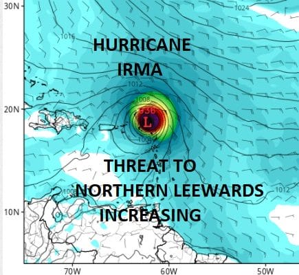
IRMA Category 3 Risk Increasing Northern Leeward Islands
IRMA Category 3 Risk Increasing Northern Leeward Islands

Hurricane Irma is back to a category 3 hurricane as the satellite loop overnight shows that Irma’s eye has become better defined again. The satellite presentaion has vastly improved since yesterday. The important development has been the west southwest motion which continues today and Irma is losing latitude as it moves westward. The eye of Irma is now south of 18 degrees north and the hurricane begins to approach 50 degrees west. Weather models continue to show Irma responding to the building Atlantic ridge. Irma being a well developed system is going to probably respond to the northeast winds at the higher levels of the atmosphere for a longer period of time. This to me puts the Northern Leeward Islands now at an increased risk of experiencing hurricane conditions or certainly tropical storm conditions beginning on Tuesday. Those islands should monitor Irma very closely today.

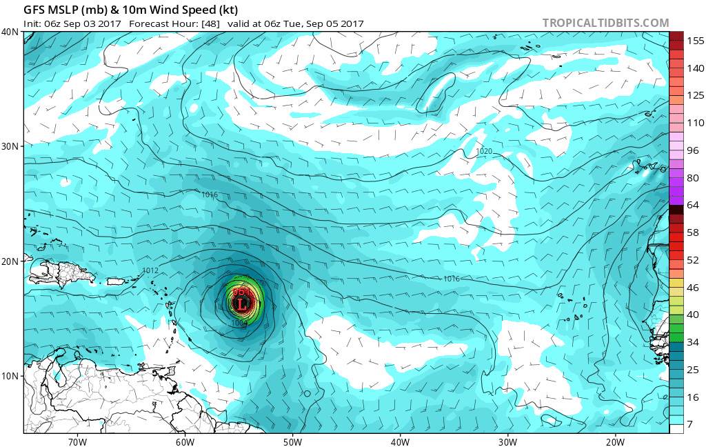
Irma also appears to be slowly expanding its size as it moves west southwestward. The upper low to the northwest of Irma continues to track to the west in sync with the hurricane. Outflow conditions are good water temperatures are much warmer west of 45 degrees west so gradual strengthening should begin.

…IRMA’S INTENSITY CONTINUES TO FLUCTUATE AND IS BACK TO
CATEGORY 3 STRENGTH…
…INTERESTS IN THE LEEWARD ISLANDS SHOULD MONITOR THE PROGRESS
OF IRMA…
SUMMARY OF 500 AM AST…0900 UTC…INFORMATION
———————————————-
LOCATION…18.0N 47.5W
ABOUT 945 MI…1520 KM E OF THE LEEWARD ISLANDS
MAXIMUM SUSTAINED WINDS…115 MPH…185 KM/H
PRESENT MOVEMENT…WSW OR 255 DEGREES AT 15 MPH…24 KM/H
MINIMUM CENTRAL PRESSURE…969 MB…28.62 INCHES
WATCHES AND WARNINGS
——————–
There are no coastal watches or warnings in effect.
Interests in the Leeward Islands should monitor the progress of
Irma.
DISCUSSION AND 48-HOUR OUTLOOK
——————————
At 500 AM AST (0900 UTC), the eye of Hurricane Irma was located
near latitude 18.0 North, longitude 47.5 West. Irma is moving
toward the west-southwest near 15 mph (24 km/h), and this course at
a slightly slower forward speed is expected through tonight. A turn
toward the west is forecast on Monday.
Maximum sustained winds have increased to near 115 mph (185 km/h)
with higher gusts. Irma is a category 3 hurricane on the
Saffir-Simpson Hurricane Wind Scale. Some additional strengthening
is forecast through Monday night.
Hurricane-force winds extend outward up to 25 miles (35 km) from the
center, and tropical-storm-force winds extend outward up to 80 miles
(130 km).
The estimated minimum central pressure is 969 mb (28.62 inches).
HAZARDS AFFECTING LAND
———————-
None
Weather models overnight continues a shift to the west both in the short and longer term. Most of the globlal models bring Irma over or just north of the Northern Leewards and the European model brings Irma dangerously close to the north shore of Puerto Rico though it does pass to the north of the island.
All the models shifted westward overnight and this shift would increase the threat longer term to the Eastern Bahamas certainly for late this week. The upper air pattern in the long range seems to becoming more into focus now as it all the global models seem to agree at least for now that the upper trough in the northeast will pull out quickly next weekend closing any offshore escape route. Irma could then respond to weak troughing to the west in the Mississippi and Ohio Valley and track northwestward toward the Southeast Coast of the US.
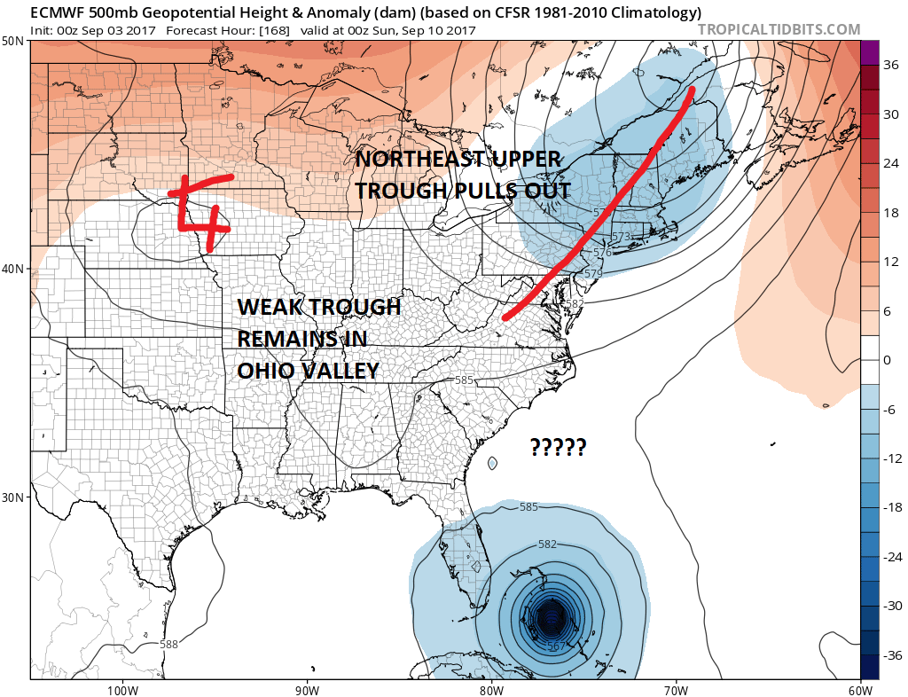
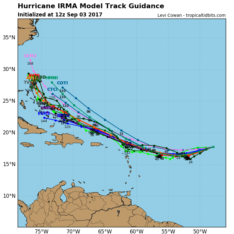
Models continue to shift westward with the European doing the biggest westward shift overnight. It now is the furthest east of all the global models but all the global models make some sort of US landfall. Now that we know that the weather models are in sync with the look of the upper air (and assuming it doesnt change again), the speed at which that northeast trough pulls out will be key to how far east or how far west Irma ultimately gets. The hurricane track models also continue to shift slightly south toward the Leeward Islands and westward near the end of the period as Irma moves toward the Southeast coast.
With regards to intensity in the long range there does not appear to be anything to stop Irma from becoming a category 4 hurricane over the next several days and it should be at least a category 4 hurricane as it begins to approach the Eastern Bahamas later this week.
MANY THANKS TO TROPICAL TIDBITS FOR THE WONDERFUL USE OF THE MAPS
 GET JOE A CIGAR IF YOU LIKE

Weather App

Don’t be without Meteorologist Joe Cioffi’s weather app. It is really a meteorologist app because you get my forecasts and my analysis and not some automated computer generated forecast based on the GFS model. This is why your app forecast changes every 6 hours. It is model driven with no human input at all. It gives you an icon, a temperature and no insight whatsoever.
It is a complete weather app to suit your forecast needs. All the weather information you need is right on your phone. Android or I-phone, use it to keep track of all the latest weather information and forecasts. This weather app is also free of advertising so you don’t have to worry about security issues with your device. An accurate forecast and no worries that your device is being compromised.
Use it in conjunction with my website and my facebook and twitter and you have complete weather coverage of all the latest weather and the long range outlook. The website has been redone and upgraded. Its easy to use and everything is archived so you can see how well Joe does or doesn’t do when it comes to forecasts and outlooks.
Just click on the google play button or the apple store button on the sidebar for my app which is on My Weather Concierge. Download the app for free. Subscribe to my forecasts on an ad free environment for just 99 cents a month.
Get my forecasts in the palm of your hand for less than the cost of a cup of Joe!