IRMA CAT 4 155 MPH HURRICANE WARNINGS FLORIDA

IRMA CAT 4 150 MPH HURRICANE WARNINGS FLORIDA
Irma is barely beneath Category 5 strength for the first time in over 2 days making it the longest lasting Category 5 hurricane in either Atlantic or the Eastern Pacific. i would expect Irma to remain at least a Category 4 hurricane until landfall early Sunday morning. Whether it strengthens back to a category 5 again or not will depend on how close the eye wall comes to the North Coast of Cuba before turning northward. Landfall from my view will be Sunday morning around daybreak plus or minus a few hours somewhere in South Florida and up along or just west of I-95.
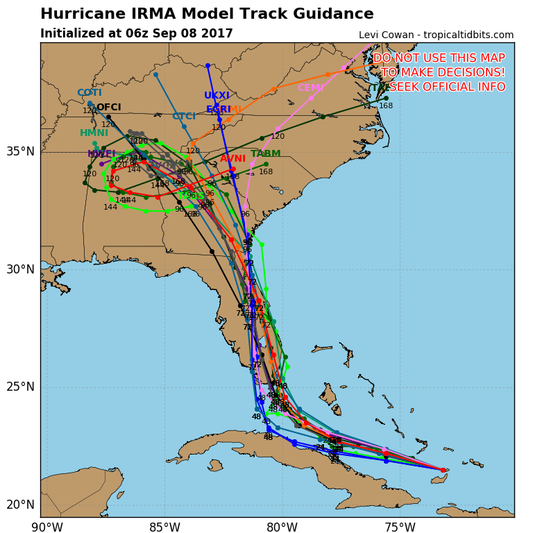
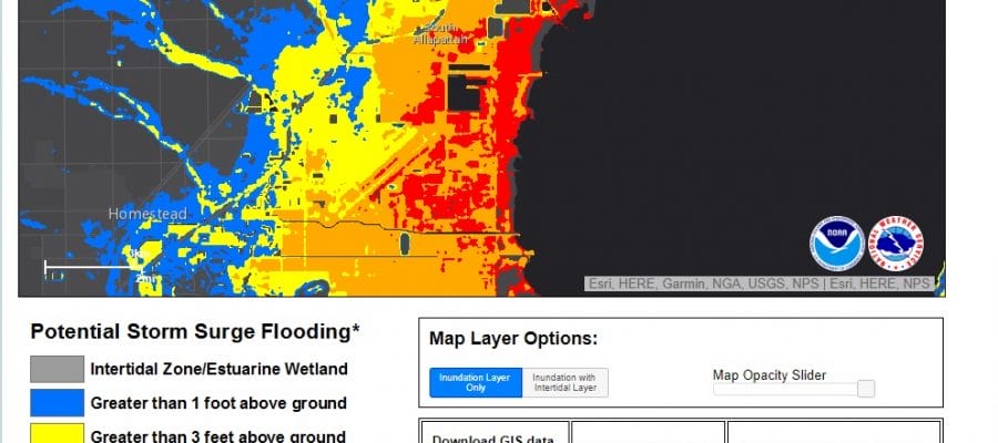
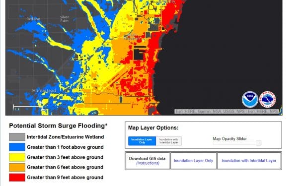
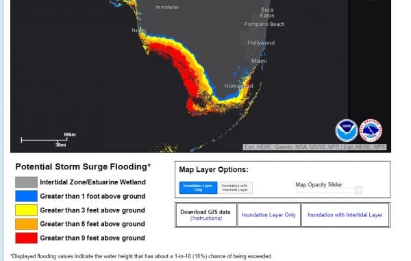
Every single hurricane track model brings it inland as do all the Global Models. The European is the furthest west, the GFS the furthest east and everyone else right in between. Based on the National Hurricane Center’s forecast track storm inundation is forecast to be extensive from Miami southward and up along and northward on the west coast as well. Clicking on the pics will take you to the National Hurricane Center’s storm inundation tool. The red on the map indicates areas that are expected to see water 9 feet or more above the ground.

…CORE OF HURRICANE IRMA FORECAST TO MOVE BETWEEN THE CENTRAL
BAHAMAS AND THE NORTH COAST OF CUBA TODAY…
SUMMARY OF 800 AM EDT…1200 UTC…INFORMATION
———————————————-
LOCATION…21.8N 74.7W
ABOUT 80 MI…125 KM NE OF CABO LUCRECIA CUBA
ABOUT 450 MI…720 KM SE OF MIAMI FLORIDA
MAXIMUM SUSTAINED WINDS…150 MPH…240 KM/H
PRESENT MOVEMENT…WNW OR 285 DEGREES AT 16 MPH…26 KM/H
MINIMUM CENTRAL PRESSURE…927 MB…27.37 INCHES
WATCHES AND WARNINGS
——————–
CHANGES WITH THIS ADVISORY:
The Hurricane and Tropical Storm Warnings for Haiti have been
discontinued.
SUMMARY OF WATCHES AND WARNINGS IN EFFECT:
A Storm Surge Warning is in effect for…
* Jupiter Inlet southward around the Florida peninsula to Bonita
Beach
* Florida Keys
A Storm Surge Watch is in effect for…
* North of Jupiter Inlet to Sebastian Inlet
* North of Bonita Beach to Venice
A Hurricane Warning is in effect for…
* Jupiter Inlet southward around the Florida peninsula to Bonita
Beach
* Florida Keys
* Lake Okeechobee
* Florida Bay
* Southeastern Bahamas and the Turks and Caicos Islands
* Cuban provinces of Camaguey, Ciego de Avila, Sancti Spiritus, and
Villa Clara
* Central Bahamas
* Northwestern Bahamas
A Hurricane Watch is in effect for…
* North of Jupiter Inlet to Sebastian Inlet
* North of Bonita Beach to Anna Maria Island
* Cuban provinces of Guantanamo, Holguin, Las Tunas and Matanzas
A Tropical Storm Warning is in effect for…
* Cuban provinces of Guantanamo, Holguin, and Las Tunas
A Storm Surge Warning means there is a danger of life-threatening
inundation, from rising water moving inland from the coastline,
during the next 36 hours in the indicated locations. For a
depiction of areas at risk, please see the National Weather
Service Storm Surge Watch/Warning Graphic, available at
hurricanes.gov. This is a life-threatening situation. Persons
located within these areas should take all necessary actions to
protect life and property from rising water and the potential for
other dangerous conditions. Promptly follow evacuation and other
instructions from local officials.
A Storm Surge Watch means there is a possibility of life-
threatening inundation, from rising water moving inland from the
coastline, in the indicated locations during the next 48 hours.
For a depiction of areas at risk, please see the National Weather
Service Storm Surge Watch/Warning Graphic, available at
hurricanes.gov.
A Hurricane Warning means that hurricane conditions are expected
somewhere within the warning area. Preparations to protect life and
property should be rushed to completion.
A Hurricane Watch means that hurricane conditions are possible
within the watch area. A watch is typically issued 48 hours
before the anticipated first occurrence of tropical-storm-force
winds, conditions that make outside preparations difficult or
dangerous.
A Tropical Storm Warning means that tropical storm conditions are
expected somewhere within the warning area.
Interests elsewhere in Cuba, Florida, and the southeastern United
States should monitor the progress of Irma.
For storm information specific to your area in the United
States, including possible inland watches and warnings, please
monitor products issued by your local National Weather Service
forecast office. For storm information specific to your area outside
the United States, please monitor products issued by your national
meteorological service.
DISCUSSION AND 48-HOUR OUTLOOK
——————————
At 800 AM EDT (1200 UTC), the eye of Hurricane Irma was located near
latitude 21.8 North, longitude 74.7 West. Irma is moving toward the
west-northwest near 16 mph (26 km/h), and this motion is expected to
continue for the next day or so with a decrease in forward speed. A
turn toward the northwest is expected by late Saturday. On the
forecast track, the eye of Irma should move near the north coast
of Cuba and the central Bahamas today and Saturday, and be near the
Florida Keys and the southern Florida Peninsula Sunday morning.
Maximum sustained winds are near 150 mph (240 km/h) with higher
gusts. Irma is a category 4 hurricane on the Saffir-Simpson
Hurricane Wind Scale. Some fluctuations in intensity are likely
during the next day or two, but Irma is forecast to remain a
powerful category 4 hurricane as it approaches Florida.
Hurricane-force winds extend outward up to 70 miles (110 km) from
the center and tropical-storm-force winds extend outward up to 185
miles (295 km).
The latest minimum central pressure reported by a reconnaissance
plane was 927 mb (27.37 inches).
HAZARDS AFFECTING LAND
———————-
STORM SURGE: The combination of a dangerous storm surge and the
tide will cause normally dry areas near the coast to be flooded by
rising waters moving inland from the shoreline. The water is
expected to reach the following HEIGHTS ABOVE GROUND if the peak
surge occurs at the time of high tide…
Jupiter Inlet to Bonita Beach, including Florida Keys…5 to 10 ft
Bonita Beach to Venice…3 to 5 ft
Jupiter Inlet to Sebastian Inlet…3 to 6 ft
The deepest water will occur along the immediate coast in areas of
onshore winds, where the surge will be accompanied by large and
destructive waves. Surge-related flooding depends on the relative
timing of the surge and the tidal cycle, and can vary greatly over
short distances. For information specific to your area, please see
products issued by your local National Weather Service forecast
office.
The combination of a life-threatening storm surge and large breaking
waves will raise water levels ABOVE NORMAL TIDE LEVELS by the
following amounts within the hurricane warning area near and to the
north of the center of Irma. Near the coast, the surge will be
accompanied by large and destructive waves.
Turks and Caicos Islands…15 to 20 ft
Southeastern and central Bahamas…15 to 20 ft
Northwestern Bahamas…5 to 10 ft
Northern coast of Haiti and the Gulf of Gonave…1 to 3 ft
Northern coast of Cuba in the warning area…5 to 10 ft
WIND: Hurricane conditions are occurring on the Turks and Caicos
Islands, with tropical storm and hurricane conditions ongoing in the
southeastern Bahamas. These conditions will move into the central
Bahamas later today. Hurricane conditions are expected within the
hurricane warning area along the north coast of Cuba late today and
Saturday. Hurricane conditions are expected in the northwestern
Bahamas tonight and Saturday, and in portions of southern Florida
and the Florida Keys Saturday night or early Sunday.
Hurricane conditions are possible within the watch area in Florida
by Sunday, with tropical storm conditions possible by late Saturday.
RAINFALL: Irma is expected to produce the following rain
accumulations through Tuesday night:
Northern Dominican Republic and northern Haiti…additional 2 to 4
inches.
Southern Dominican Republic and southern Haiti…additional 1 to 2
inches.
Turks and Caicos…additional 3 to 6 inches.
Southern Bahamas and northern Cuba…10 to 15 inches, isolated 20
inches.
Southern Cuba…4 to 8 inches, isolated 12 inches.
The upper Florida Keys into southeast Florida…10 to 15 inches,
isolated 20 inches.
Eastern Florida northward into coastal Georgia…8 to 12 inches,
isolated 16 inches.
Lower Florida Keys…3 to 5 inches.
Western Florida Peninsula into much of Georgia…South
Carolina…and Western North Carolina…3 to 6 inches.
In all areas this rainfall may cause life-threatening flash floods
and in some areas mudslides.
SURF: Swells generated by Irma are affecting Puerto Rico, the
Virgin Islands, the southeastern Bahamas, the Turks and Caicos
Islands, the northern coast of the Dominican Republic, and should
start affecting portions of the southeast coast of the United States
later today and tonight. These swells are likely to cause
life-threatening surf and rip current conditions. Please consult
products from your local weather office.

At this point there isn’t much more to say about this regarding the outcome. I don’t really expect too much change going forward so it is a matter of whether the landfall adjusts a little bit to the left or a little bit to the right.

MANY THANKS TO TROPICAL TIDBITS FOR THE WONDERFUL USE OF THE MAPS
 GET JOE A CIGAR IF YOU LIKE

Weather App

Don’t be without Meteorologist Joe Cioffi’s weather app. It is really a meteorologist app because you get my forecasts and my analysis and not some automated computer generated forecast based on the GFS model. This is why your app forecast changes every 6 hours. It is model driven with no human input at all. It gives you an icon, a temperature and no insight whatsoever.
It is a complete weather app to suit your forecast needs. All the weather information you need is right on your phone. Android or I-phone, use it to keep track of all the latest weather information and forecasts. This weather app is also free of advertising so you don’t have to worry about security issues with your device. An accurate forecast and no worries that your device is being compromised.
Use it in conjunction with my website and my facebook and twitter and you have complete weather coverage of all the latest weather and the long range outlook. The website has been redone and upgraded. Its easy to use and everything is archived so you can see how well Joe does or doesn’t do when it comes to forecasts and outlooks.
Just click on the google play button or the apple store button on the sidebar for my app which is on My Weather Concierge. Download the app for free. Subscribe to my forecasts on an ad free environment for just 99 cents a month.
Get my forecasts in the palm of your hand for less than the cost of a cup of Joe!