
Improving Weather Later Today Severe Weather Risks Wednesday Thursday Ahead of Easter Weekend

Improving Weather Later Today Severe Weather Risks Wednesday Thursday Ahead of Easter Weekend

We have one of these situations this morning where a “cold” front moving through with showers and they are clearly showing up on the radar. We can also see the sharp western edge cut off of clouds on the satellite picture as well as the radar echoes. Over the next few hours these showers will move east and offshore and clouds will move quickly eastward. This will allow us to transition over to sunshine around midday and the afternoon should be no worse than partly sunny. Since the air behind the front is actually warmer than the air ahead of it, highs will reach the low and middle 70s this afternoon.
SATELLITE

WEATHER RADAR

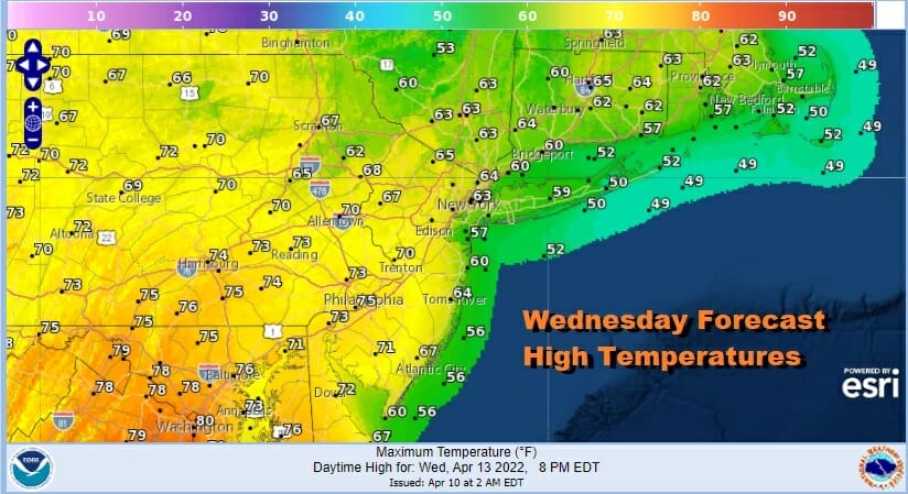
Moving along over the next two days we are going to see a slight change Wednesday. Winds will be more from the south rather than from the west (like today) and that will knock off a few degrees off the temperatures. Look for highs reaching into the 70s inland west and southwest of NYC but it will be mostly in the 60s to the north and east and 50s along south facing shorelines. Skies should be no worse than partly sunny especially inland.
While warm air is going to be overwhelming the Eastern US we have cold air spreading through the Plains today all thanks to a major storm in the Northern Plains. It is producing blizzard conditions and ridiculous snow amounts for this time of year. 2 to 3 feet of snow is possible over parts of North Dakota. The storm responsible for this is also driving a large area of severe weather risk across the Eastern Plains and the Mississippi Valley from south to north.

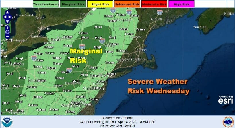
There will be a area of severe weather risk Wednesday late in the day and evening as a warm front moves northward. Most of the thunderstorm risk sets up west of the coast and the severe weather risk Wednesday (which is a marginal risk) sets up in Eastern Pennsylvania to the west of the New Jersey Pennsylvania state line.
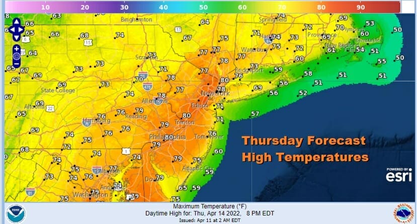
Thursday will be the warmest day of the week as a cold front approaches. Look for sun and clouds with a southwest wind. Highs will reach the upper 70s and lower 80s with temperatures a little lower along coastal locations and south facing shorelines.
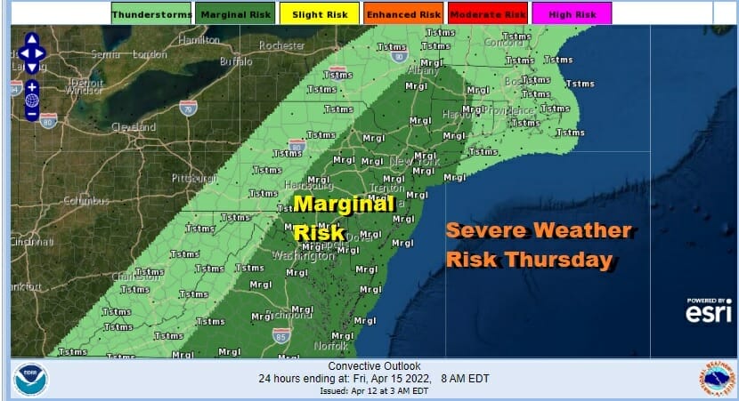
This storm system from the Dakotas heads well to the west and north so I don’t think we see widespread severe weather late Thursday however there will be some severe weather risk with the front and an upper trough swinging east so a marginal risk of severe weather is being indicated by the Storm Prediction Center.
Friday through Sunday we see a slow stair step decline in temperatures. Friday looks to be dry with sunshine and clouds. Highs will be in the 60s. The same holds for Saturday but we have another cold front and the chance for showers or a thunderstorm late in the day. Highs again will be in the 60s.

The cold front moves offshore and this leaves us with a chilly dry Easter Sunday with some sunshine and a gusty breeze. Highs will be just in the low to mid 50s. The next weather system follows with rain or showers on Monday. More cold fronts and more opportunities for showers will be in the cards for next week.
BE SURE TO DOWNLOAD THE FREE METEOROLOGIST JOE CIOFFI WEATHER APP &
ANGRY BEN’S FREE WEATHER APP “THE ANGRY WEATHERMAN!
MANY THANKS TO TROPICAL TIDBITS & F5 WEATHER FOR THE USE OF MAPS
Please note that with regards to any severe weather, tropical storms, or hurricanes, should a storm be threatening, please consult your local National Weather Service office or your local government officials about what action you should be taking to protect life and property.


