Improvement Comes Slowly

Improvement Comes Slowly
Cloud Issues Through Thursday
On & Off Sunshine
Weekend Coastal Low Threat Remains

This morning’s satellite loop shows lots of clouds nearby and even an area of rain moving across Pennsylvania. That area of rain is forecast to weaken as it moves eastward and never survives the trip over the mountains. We will call it a mix of clouds with some breaks of sunshine for today. Given that this time of year any sunshine can boost temperatures up toward 70, we should see temperatures reaching upper 60s to lower 70s during this afternoon. No issue tonight other than clouds with lows in the 50s.
Improvement Comes Slowly
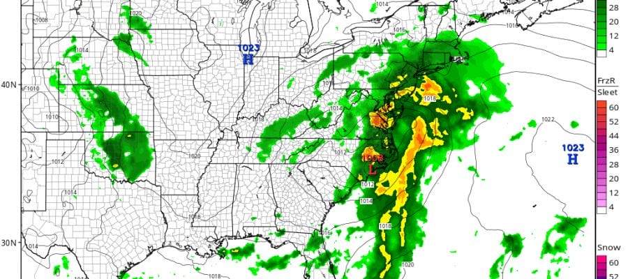
Radar Loops


For Thursday we have an upper air disturbance that will be moving across upstate New York and Northern New England. This is going to be another one of these systems that produces clouds and not much precipitation. However there will be a few showers widely scattered around Thursday afternoon and evening. High will be in the upper 60s to lower 70s again. Then we have what should be a good day on Friday with a fair amount of sunshine and highs in the low to mid 70s.
NAM MODEL SATURDAY AFTERNOON 2PM

We seem to be on course for some rain later Saturday and Saturday night as the first of 2 coastal lows head our way. Once again the recent trend has been south and there is going to be a question as to how far north and west of the coast the rain will get. Also we have a full moon Saturday night so there will be the question of some tidal flooding possibilities at high tide. Overnight model runs were also less bullish with a second low as models seemed weaker and further east given the way the upper air is evolving. We will address the issue further later today.
FiOS1 News Weather Forecast For Long Island
FiOS1 News Weather Forecast For New Jersey
FiOS1 News Weather Forecast For Hudson Valley
NATIONAL WEATHER SERVICE SNOW FORECASTS
LATEST JOESTRADAMUS ON THE LONG RANGE
Weather App

Don’t be without Meteorologist Joe Cioffi’s weather app. It is really a meteorologist app because you get my forecasts and my analysis and not some automated computer generated forecast based on the GFS model. This is why your app forecast changes every 6 hours. It is model driven with no human input at all. It gives you an icon, a temperature and no insight whatsoever.
It is a complete weather app to suit your forecast needs. All the weather information you need is right on your phone. Android or I-phone, use it to keep track of all the latest weather information and forecasts. This weather app is also free of advertising so you don’t have to worry about security issues with your device. An accurate forecast and no worries that your device is being compromised.
Use it in conjunction with my website and my facebook and twitter and you have complete weather coverage of all the latest weather and the long range outlook. The website has been redone and upgraded. Its easy to use and everything is archived so you can see how well Joe does or doesn’t do when it comes to forecasts and outlooks.
Just click on the google play button or the apple store button on the sidebar for my app which is on My Weather Concierge. Download the app for free. Subscribe to my forecasts on an ad free environment for just 99 cents a month.
Get my forecasts in the palm of your hand for less than the cost of a cup of Joe!
![]()
![]()

MENTION JOE CIOFFI AND GET A 5% DISCOUNT


