Idalia Ashore in Florida, Warnings Extended Through North Carolina,
No Issues Northeast Northern Mid Atlantic States
Idalia Ashore in Florida, Warnings Extended Through North Carolina,
No Issues Northeast Northern Mid Atlantic States
Hurricane Idalia has come ashore in North Florida along the Florida Big Bend as a category 4 hurricane. It will now make a move northeastward and spread hurricane conditions across North Florida into Southern Georgia. The center is likley to hold on to strength longer as it moves to the Georgia South Carolina coast. Half the center will be offshore and this will slow the weakening process. Hurricane Warnings have been extended northward to the South Carolina coast and Tropical Storm Warnings are up from there through Coastal North Carolina to the Virginia state line.
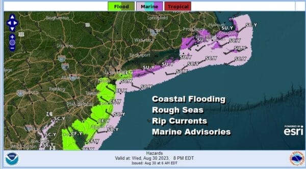
For all of the Northeast south to Virginia, there are no real issues from Idalia. However we are seeing the ocean continued to be roughed up by Hurricane Franklin. Franklin has evolved into a large hurricane by geographi coverage and it is passing to the northwest of Bermuda today and it will turn northeast tonight and Thursday. Franklin seems to be moving slower than advertised and that has created rough ocean conidtions from Eastern New England to the Southeast US and the Florida East Coast. Today through Friday we are likely to continue to see Coastal Flood Advisories, rough surf and rip tides, as well as Small Craft Advisories posted for the coastal waters.
SATELLITE WITH LIGHTNING STRIKES
WEATHER RADAR
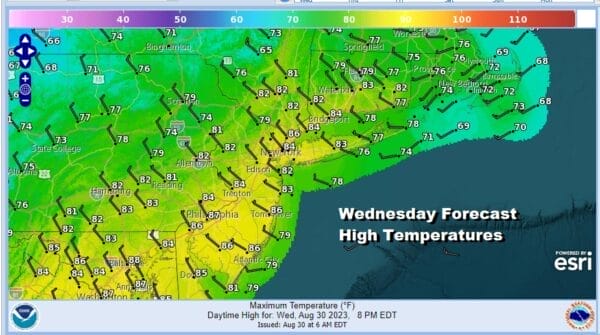
While the hurricanes are doing their “thing” we have a cold front that is moving through this morning with some showers and one or two thunderstorms. This front is taking its time move through as Franklin to the southeast bascially slows everything down behind it. Look for these showers to work through the area this morning and then offshore. Weather conditions should being to improve this afternoon with decreasing clouds and increasing sun. Highs will be in the low to middle 80s.
This will be last time we see rain for awhile. It will likely be dry at least into the middle of next week. It sets us up for a very good finish to the summer vacation season. Skies will clear out tonight as dry air comes and dew points drop. Lows will be in the 50s inland and lower 60s along the coast. Thursday we could see some high clouds sprading northward to about Southern New England as Idalia moves off the North Carolina coast but we will see sunshine through high clouds. The further north you go, the fewer clouds you will see.
Temperature and humidity wise Thursday will be rather delightful with most highs in the low to middle 70s and very low humidity levels. Another cool night sets up for Thursday night into Friday morning as the high clouds pull away and skies clear. Lows again will be in the 50s inland and low 60s coast. Friday will be a mostly sunny low humidity day with highs in the mid 70s to around 80 degrees.
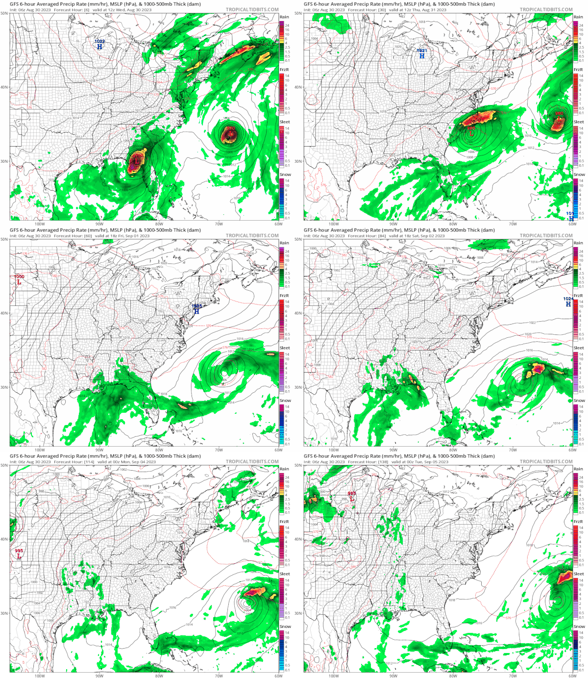
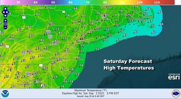
The gfs loop above shows no issues for Saturday Sunday and Monday. Idalia will be meandering somewhere well off the Southeast US coast. There are no other tropical storms or hurricanes to worry about for the Labor Day weekend. Saturday will be mostly sunny with highs in the upper 70s to lower 80s.
Sunday we will start warming up as high pressure moves offshore and we begin to not only take temperatures higher but humidity levels with start to move up as well. Skies Sunday should be mostly sunny and it will be very warm as highs reach the middle to even a few upper 80s.
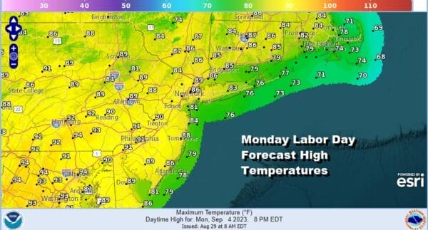
Monday Labor Day will cap off a spectacular 3 day holiday weekend with sunshine. very warm to hot and humid conditions. Highs Monday will be in the upper 80s to some lower 90s in the hot spots. Our above normal very warm and rain free weather should continue into the middle of next week as cold fronts will not be able to move into the Eastern US until the upper ridge breaks down.
BE SURE TO DOWNLOAD THE FREE METEOROLOGIST JOE CIOFFI WEATHER APP &
ANGRY BEN’S FREE WEATHER APP “THE ANGRY WEATHERMAN!
MANY THANKS TO TROPICAL TIDBITS FOR THE USE OF MAPS
Please note that with regards to any severe weather, tropical storms, or hurricanes, should a storm be threatening, please consult your local National Weather Service office or your local government officials about what action you should be taking to protect life and property.
(Amazon is an affilate of Meteorologist Joe Cioffi & earns commissions on sales.)


