Ida Arrives Heavy Rain Flash Flooding
Unusually High Severe Weather & Tornado Risk

Weather in 5/Joe & Joe Weather Show Latest Podcast
Ida Arrives Heavy Rain Flash Flooding Unusually High Severe Weather & Tornado Risk
Ida has arrived and it is making the transition over to a non tropical cyclone. It is combining with an upper trough swinging through the Great Lakes and into Southeastern Canada and that will cause the low to strengthen as it goes by. It sets up a very turbulent day with all sorts of hazards.

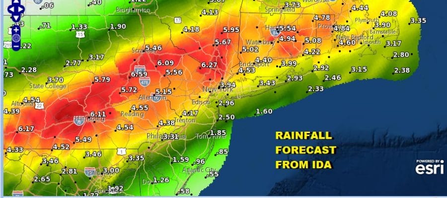
Lets start with the rain. Flash flood watches are up for everywhere from Northeast Virginia to New England. The heaviest rains fall north and west of the storm track which is going to cut right across the major cities along or just to the east of I-95. South of the track the rain will be a bit less but still substantial.
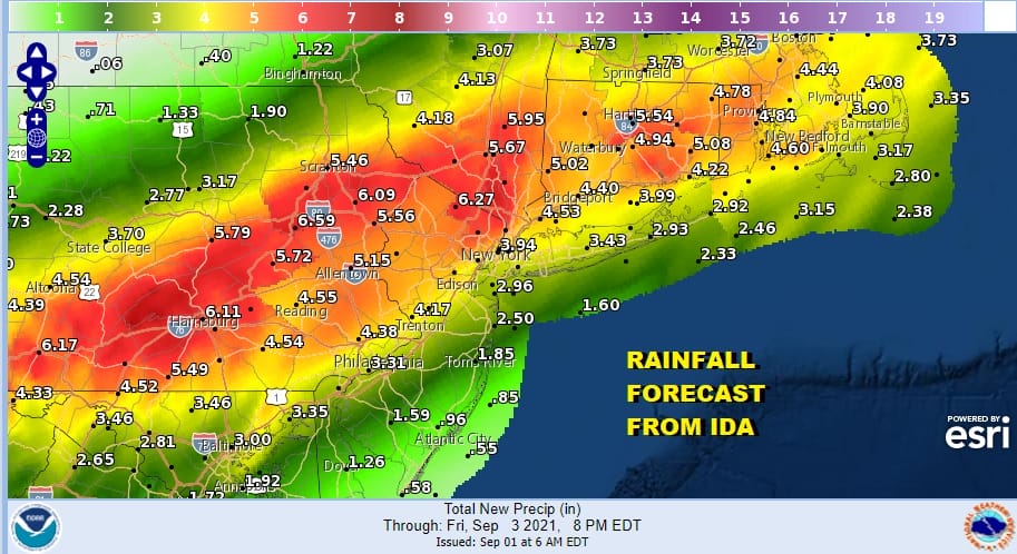
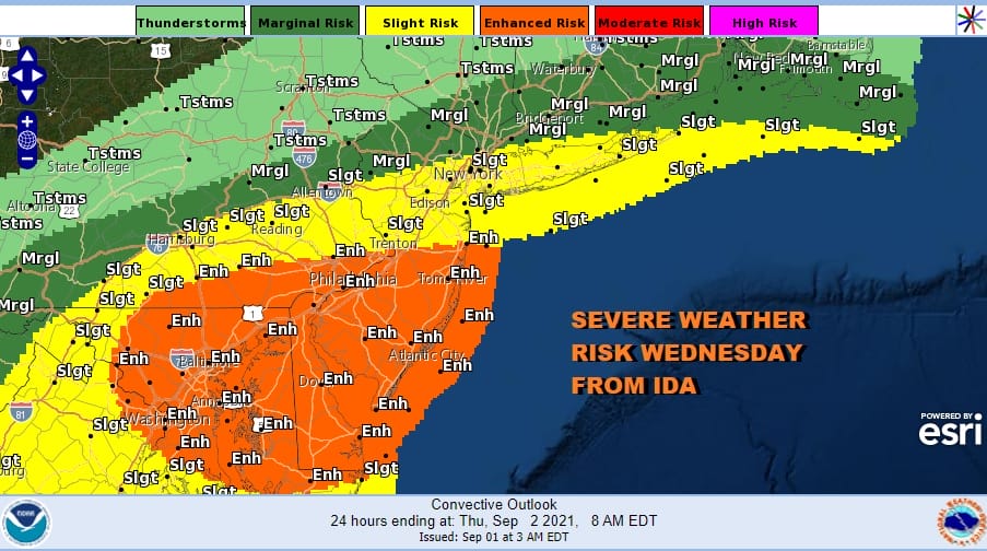
Rainfall south of that track drops off because it will be more convective and that brings us to the second issue today and it is that of severe weather. We have unusually high risks for severe weather today especially across Central and South Jersey, Southern Pennsylvania south into Maryland and Northeast Virginia. The Storm Prediction Center has an enhanced risk set there with slight risk reaching Northern New Jersey, NYC, and Long Island and a marginal risk into Southern New England.
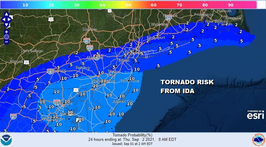
That severe weather risk comes with an usually high tornado risk of a rarely seen 10 percent risk inside that enhanced risk zone with 5% in the slight risk and 2% on the northern flank in Southern New England, Long Island and Northern New Jersey. The highest threat time will be this evening and tonight when the storm will be having its largest impact.
Ida’s circulation is clearly well defined on the satellite loop. This loop is called a floater loop as it is centered on the storm and the geography moves. Ida is on a steady faster track to the northeast
SATELLITE

The lead rains have arrived on the radars. Gradually as we move through the day the steady rain pivots northward and we start to see the convective development of severe weather in the risk zones outlined above this afternoon into tonight. We have added additional radar views which can be updated simply by refreshing this page. We should also note that widespread wind issues are not expected however severe thunderstorms could easily produce wind gusts of 50 mph or more so be alert to that possibility in severe weather risk areas.
WEATHER RADAR


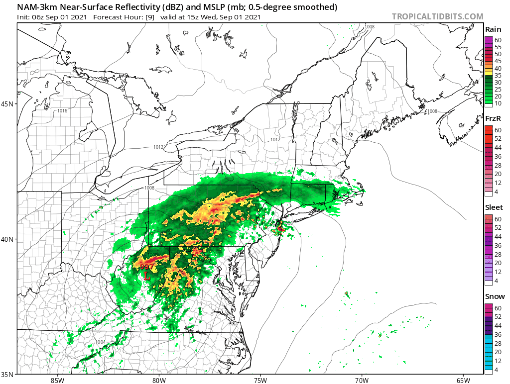
The storm track is key to what you can expect. If you are south and east of I-95 rains will be more convective and showery and you have have the greatest severe weather risk. If you are north and west of I-95 you have some severe weather risk but less than areas to the south and more continuous pouring rains. The NAM model shows its view on how it plays out. It isn’t going to a perfect prediction here.
Ida will begin to move away late tonight as it ends across Pennsylvania around midnight or so and exits Eastern Long Island around 5am. Weather conditions will improve quickly on Thursday as a beautiful dry air mass builds and brings sunshine, low humidity, a gusty wind and highs in the 70s. Pay close attention to weather developments today including likely severe weather watches that will go up for some areas late today.
BE SURE TO DOWNLOAD THE FREE METEOROLOGIST JOE CIOFFI WEATHER APP &
ANGRY BEN’S FREE WEATHER APP “THE ANGRY WEATHERMAN!
MANY THANKS TO TROPICAL TIDBITS & F5 WEATHER FOR THE USE OF MAPS
Please note that with regards to any severe weather, tropical storms, or hurricanes, should a storm be threatening, please consult your local National Weather Service office or your local government officials about what action you should be taking to protect life and property.


