Hurricane Warnings Most of Long Island Connecticut
Tropical Storm Warnings NYC to Manasquan NJ

Weather in 5/Joe & Joe Weather Show Latest Podcast
Hurricane Warnings Most of Long Island Connecticut
Tropical Storm Warnings NYC to Manasquan NJ
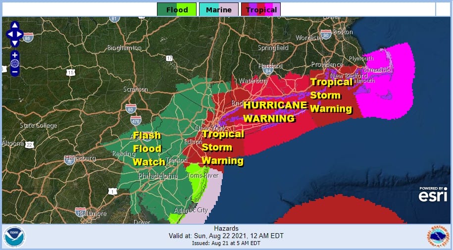
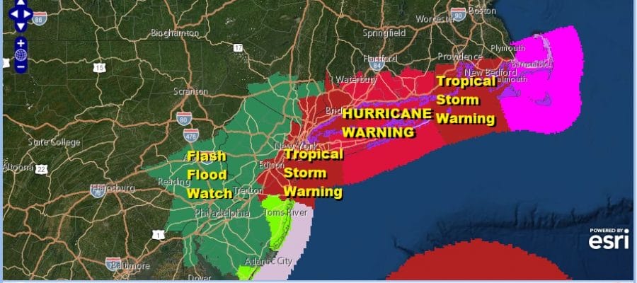
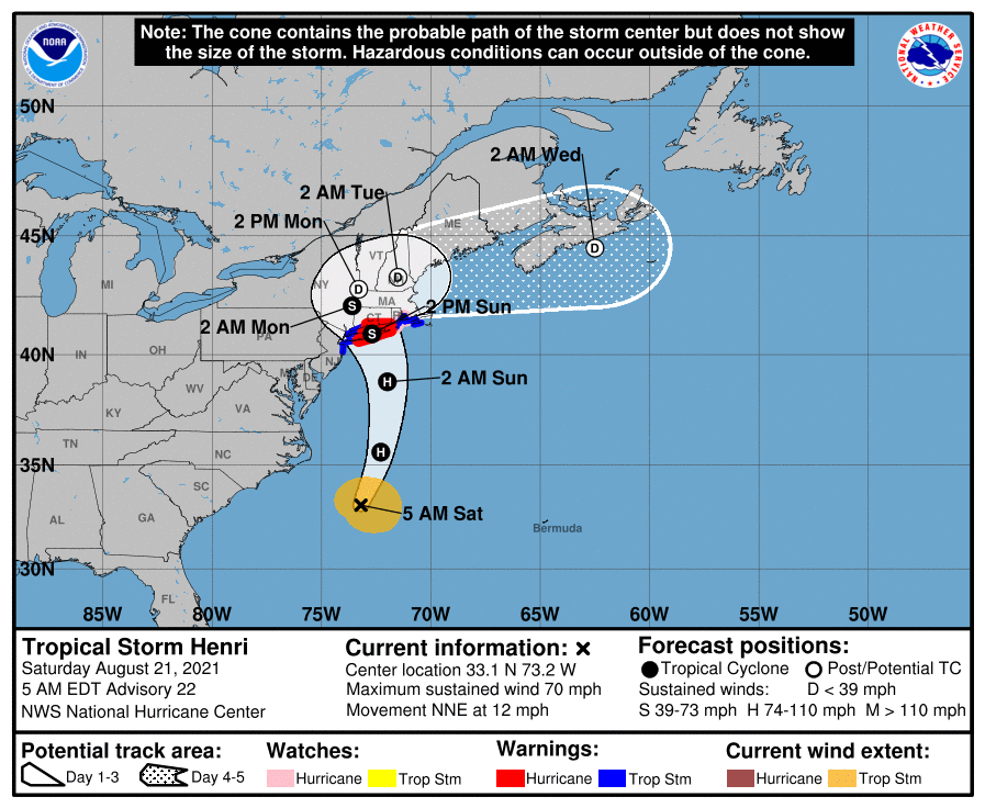
Hurricane Warnings continue for most of Long Island and Connecticut. Tropical Storm Warnings are up either side of the Hurricane Warning area and now include NYC and the New Jersey counties surrounding NY Harbor south to Manasquan. Flash Flood Watches are now up for New Jersey as the heaviest rains will fall west of the storm track.
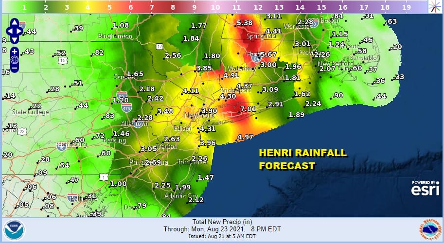
Some rather impressive rainfall amounts are being indicated by NWS digital forecasts. There are two areas to pay attention. One along and just west of the storm track. The other is inland north and west of the track where we start to encounter elevation. This will create extra lift and could potentially squeeze our a lot of rain for somebody. This explains why we are seeing big rains north up the Connecticut River Valley. Enhancement of rain could also occur in Northern New Jersey and into Eastern Pennsylvania which is where an upper air low is going to be tracking north northeastward at the same time.
SUMMARY OF WATCHES AND WARNINGS IN EFFECT:
A Storm Surge Warning is in effect for…
* South shore of Long Island from Mastic Beach to Montauk Point New
York
* North shore of Long Island from Montauk Point to Flushing New York
* Flushing New York to Chatham Massachusetts
* Nantucket, Martha’s Vineyard, and Block Island
A Storm Surge Watch is in effect for…
* East Rockaway Inlet to Mastic New York
* North of Chatham Massachusetts to Sagamore Beach Massachusetts
* Cape Cod Bay
A Hurricane Warning is in effect for…
* South shore of Long Island from Fire Island Inlet to Montauk Point
* North shore of Long Island from Port Jefferson Harbor to Montauk
Point
* New Haven Connecticut to west of Watch Hill Rhode Island
A Hurricane Watch is in effect for…
* Watch Hill Rhode Island to Westport Massachusetts
* Block Island
A Tropical Storm Warning is in effect for…
* Port Jefferson Harbor to west of New Haven Connecticut
* South shore of Long Island from west of Fire Island Inlet to East
Rockaway Inlet
* Watch Hill Rhode Island to Woods Hole Massachusetts including
Block Island and Martha’s Vineyard.
* Coastal New York and New Jersey west of East Rockaway Inlet to
Manasquan Inlet, including New York City
SATELLITE

We have seen little change in Henri overnight. After two days of strong northeasterly wind shear, even though the shear has relaxed, Henri has not shown strengthening overnight. The window for strengthening is closing once Henri gets north of 36 degrees north. Water temperatures cool north of this line and will not support strengthening. In the meantime today it will be another warm and very humid day as the atmosphere basically primes itself for Henri. Highs will be in the 80s. Watch for passing showers or a scattered heavier downpour.
WEATHER RADAR


The first bands of Henri are beginning to appear on the regional radar east of North Carolina and Virginia and they will gradually spread northward as the day wears on. Tonight clouds will thicken up and weather conditions will begin to deteriorate from southeast to northwest during the early morning hours Sunday.
I could have pulled any model and no two had the same track so I opted for the HRRR model from 1pm today through 1am Monday. It illustrates the idea that heaviest rain will be to the west and stronger winds will be to the east. Landfall will be sometime Sunday morning and I think the NHC forecast is ok at this point with the center cutting across Central Long Island.
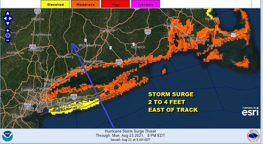
With regards to storm surge of 2 to 4 feet it will occur east of the track of the storm so mainly from the coast of Central Long Island eastward to Block Island. The wind in the opposite direction on the west side will blow the water out. Remember if the track is further west you will have to adjust the western boundary of the surge.
In terms of a specific break down of weather conditions for your specific weather, they are too numerous to break down here. We suggest that you go to your National Weather Service forecast office page for specifics regarding your particular area. If you are a member of my weather platform on Patreon, just send me a message.
BE SURE TO DOWNLOAD THE FREE METEOROLOGIST JOE CIOFFI WEATHER APP &
ANGRY BEN’S FREE WEATHER APP “THE ANGRY WEATHERMAN!

MANY THANKS TO TROPICAL TIDBITS & F5 WEATHER FOR THE USE OF MAPS
Please note that with regards to any severe weather, tropical storms, or hurricanes, should a storm be threatening, please consult your local National Weather Service office or your local government officials about what action you should be taking to protect life and property.


