Hurricane Warnings Long Island Southern New England
Henri Heading Northward Up The East Coast

Weather in 5/Joe & Joe Weather Show Latest Podcast
Hurricane Warnings Long Island Southern New England
Henri Heading Northward Up The East Coast
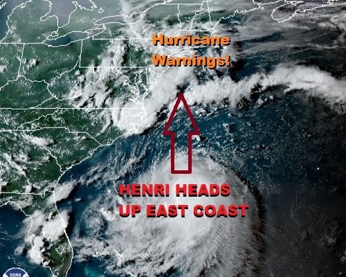
Hurricane warnings have gone up for Southern New England as well as for most of Long Island. Tropical Storm Henri is just about at hurricane strength and is heading north northwestward. Here is how it breaks down regarding warnings and watches.
SUMMARY OF WATCHES AND WARNINGS IN EFFECT:
A Storm Surge Warning is in effect for…
* South shore of Long Island from Mastic Beach to Montauk Point
* North shore of Long Island from Oyster Bay to Montauk Point
* Greenwich Connecticut to Chatham Massachusetts
* Nantucket, Martha’s Vineyard, and Block Island
A Storm Surge Watch is in effect for…
* South shore of Long Island from west of Mastic Beach to East
Rockaway Inlet
* North shore of Long Island from west of Oyster Bay to Flushing
* Flushing New York to west of Greenwich Connecticut
* North of Chatham Massachusetts to Sagamore Beach Massachusetts
* Cape Cod Bay
A Hurricane Warning is in effect for…
* South shore of Long Island from Fire Island Inlet to Montauk Point
* North shore of Long Island from Port Jefferson Harbor to Montauk
Point
* New Haven Connecticut to west of Watch Hill Rhode Island
A Hurricane Watch is in effect for…
* Watch Hill Rhode Island to Sagamore Beach Massachusetts
* Nantucket, Martha’s Vineyard, and Block Island
A Tropical Storm Warning is in effect for…
* Port Jefferson Harbor to west of New Haven Connecticut
* South shore of Long Island from west of Fire Island Inlet to East
Rockaway Inlet
A Tropical Storm Watch is in effect for…
* Manasquan Inlet New Jersey to west of East Rockaway Inlet New
York, including New York City
SATELLITE

Henri is getting that “feathering” of the cloud cover in the outflow that is typical of storms that are about to strengthen. The cloud signature has improved since yesterday and last night and the center is under the deep convection as the wind shear issues continue to diminish. We expect Henri to strengthen overnight and on Saturday as it heads up the coast.
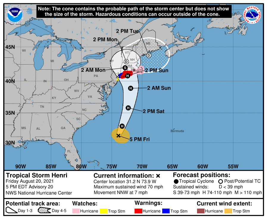
The National Hurricane Center forecast has been nudged a little more to the left or west. Landfall over Central or Eastern Long Island is expected to occur around midday Sunday. Until then there are no major weather issues tonight which will be warm and humid with lows in the upper 60s and lower 70s. Saturday looks mostly cloudy with a few breaks of sun for the entire area from Eastern Pennsylvania to Southern New England. Some downpours or thunderstorms not related to Henri could develop inland during the afternoon. Highs will reach into the 80s.
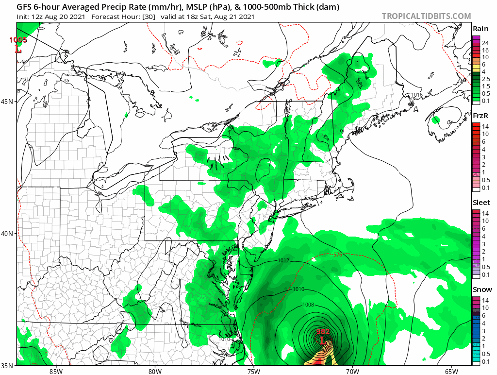
Weather conditions begin to deteriorate during the early morning hours Sunday as the winds begin to increase in the warning area and rain develops around daybreak. This will last about 6 to 8 hours of heavy rain and the strongest winds. Expect the strongest winds to be east of the storm track with the heaviest rains to the west and north west. 2 to 4 inches of rain is likely west of the track. Henri will approach and possibly come ashore as a category 1 hurricane before weakening to a tropical storm and moving inland in New England spreading heavy rain northward. The remnant low of Henri will move northeast late Sunday night and Monday and weather conditions in the warning area will start to improve Sunday night with better weather on Monday though there still could be some leftover showers. More on Henri and what to expect on tonight’s Joe & Joe Weather Show.
BE SURE TO DOWNLOAD THE FREE METEOROLOGIST JOE CIOFFI WEATHER APP &
ANGRY BEN’S FREE WEATHER APP “THE ANGRY WEATHERMAN!

MANY THANKS TO TROPICAL TIDBITS & F5 WEATHER FOR THE USE OF MAPS
Please note that with regards to any severe weather, tropical storms, or hurricanes, should a storm be threatening, please consult your local National Weather Service office or your local government officials about what action you should be taking to protect life and property.


