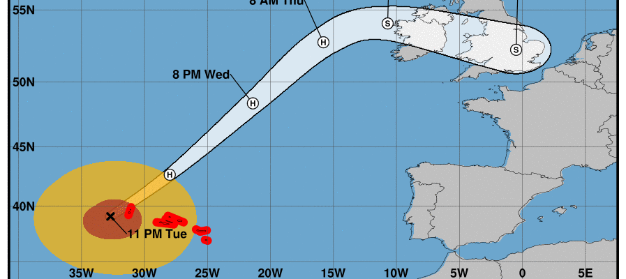
Hurricane Warnings Azores Lorenzo Moving Through Azores Then To Ireland Britain Thursday
Hurricane Lorenzo is now impacting the Azores as hurricane force winds will be sweeping through the islands overnight into Wednesday morning. As of the 11pm Advisory Lorenzo is 85 miles west southwest of Flores Island in the Azores. Maximum winds are 100 mph with higher gusts east of the center. Lorenzo will pass through the Azores and begin moving away on Wednesday though tropical storm force winds will continue at least into Wednesday morning before slowly subsiding later in the day and at night
LORENZO SATELLITE

The satellite picture still shows a well defined core though the system is looking ragged and beginning to feel the effects of colder ocean water. That is being counteracted by a strong upper air system to the northwest that is giving it a juice of upper air energy. Lorenzo will begin to slowly transition to a strong post tropical cyclone as it heads rapidly to the northeast at 30 to 40 mph. The next stop will be Ireland.

The National Hurricane Center forecast track is for a sharp right turn toward Ireland on Thursday. At this point there won’t be much tropical about it as Lorenzo will begin to look like and behave like an Atlantic Ocean cyclone. The fast movement will likely bring strong winds of at least gale force to Ireland especially to Northern Ireland where the gradient will be the tightest.

Wednesday evening global models were all very consistent with the track and strength of Lorenzo. The storm will move east southeast across Ireland and then Southern England and Wales weakening as it moves along and eventually it will get absorbed by a strong trough over Central Europe on Friday. This appears to be less strength wise than Hurricane Ophelia two years ago which came up from the south into Southern Ireland moving northeastward through Ireland and into Scotland. Weather conditions should improve from west to east during Friday and Friday night in the British Isles.
MANY THANKS TO TROPICAL TIDBITS FOR THE USE OF MAPS
Please note that with regards to any tropical storms or hurricanes, should a storm be threatening, please consult your local National Weather Service office or your local government officials about what action you should be taking to protect life and property.