Hurricane Threat Florida Panhandle Increasing
SHOP THE JOESTRADAMUS STORE
HURRICANE THREAT FLORIDA PANHANDLE INCREASING
TROPICAL DEPRESSION FORECAST TO BECOME NATE OVERNIGHT
An Air Force Plane confirmed the circulation of Tropical Depression 16 which is just below tropical storm strength. Conditions aloft are conducive for gradual strengthening over the next several days with the proximity to land the one inhibiting factor that could keep this from blowing up into another major hurricane. Banding is developing. There is no wind shear to speak of and the amount of dry air is virtually non existent. If somehow the center remains over open waters on its trip through the Northwest Caribbean there could be a period of rapid strengthening at some point. Since this year seems to be the year of the major hurricane, we can’t really rule that possibility out.


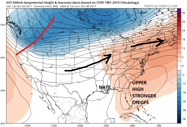
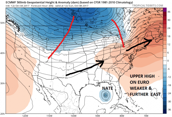
Today’s European model remains resolute in taking this on the eastern side of the model guidance envelope. There are two main differences between the European & the GFS model with regards to this system. The models handle the upper high differently and they each have their own ideas regarding the speed of movement.
GFS MODEL SUNDAY 8AM 10/08/2017
EUROPEAN MODEL SUNDAY 8AM 10/08/2017
The jet stream differences on the two major global models are very important. The European model would have a much stronger system taking a track further east while the GFS would have a faster weaker system tracking further west. The European also has a much stronger jet stream flow across the US which combined with the weaker high to the east would bring landfall to the Florida Panhandle during Sunday night. So which do we believe? It seems to me that the European has the more accurate view of the upper air profile in my opinion. This also would have implications early next week as whatever remnant low heads northeastward along or just east of the Appalachians. A track east of the mountains will put our area at risk for some rain and wind as well. The remnant low may be able to draw strength from all the jet stream energy to the northwest of it. Lots of puzzle pieces here going forward that we will need to work out so lets see where this goes over the next few days.
...LIFE-THREATENING FLASH FLOODS AND MUDSLIDES POSSIBLE OVER
PORTIONS OF CENTRAL AMERICA FROM THE DEPRESSION…
SUMMARY OF 500 PM EDT…2100 UTC…INFORMATION
———————————————-
LOCATION…12.5N 82.5W
ABOUT 55 MI…85 KM W OF SAN ANDRES ISLAND
ABOUT 180 MI…290 KM SSE OF CABO GRACIAS A DIOS ON NIC/HON BORDER
MAXIMUM SUSTAINED WINDS…35 MPH…55 KM/H
PRESENT MOVEMENT…NW OR 315 DEGREES AT 7 MPH…11 KM/H
MINIMUM CENTRAL PRESSURE…1005 MB…29.68 INCHES
WATCHES AND WARNINGS
——————–
CHANGES WITH THIS ADVISORY:
None
SUMMARY OF WATCHES AND WARNINGS IN EFFECT:
A Tropical Storm Warning is in effect for…
* Sandy Bay Sirpi Nicaragua to Punta Castilla Honduras
DISCUSSION AND 48-HOUR OUTLOOK
——————————
At 500 PM EDT (2100 UTC), the center of Tropical Depression Sixteen
was located near latitude 12.5 North, longitude 82.5 West. The
depression is moving toward the northwest near 7 mph (11 km/h), and
this motion is expected to continue tonight. On the forecast track,
the depression should be nearing the coast of Nicaragua early
Thursday, move across northeastern Nicaragua and eastern Honduras
late Thursday, and emerge into the northwestern Caribbean Sea on
Friday.
Maximum sustained winds remain near 35 mph (55 km/h) with higher
gusts. The depression is forecast to become a tropical storm
overnight.
The estimated minimum central pressure is 1005 mb (29.68 inches).
MANY THANKS TO TROPICAL TIDBITS FOR THE WONDERFUL USE OF THE MAPS
 GET JOE A CIGAR IF YOU LIKE
Weather App
Don’t be without Meteorologist Joe Cioffi’s weather app. It is really a meteorologist app because you get my forecasts and my analysis and not some automated computer generated forecast based on the GFS model. This is why your app forecast changes every 6 hours. It is model driven with no human input at all. It gives you an icon, a temperature and no insight whatsoever.
It is a complete weather app to suit your forecast needs. All the weather information you need is right on your phone. Android or I-phone, use it to keep track of all the latest weather information and forecasts. This weather app is also free of advertising so you don’t have to worry about security issues with your device. An accurate forecast and no worries that your device is being compromised.
Use it in conjunction with my website and my facebook and twitter and you have complete weather coverage of all the latest weather and the long range outlook. The website has been redone and upgraded. Its easy to use and everything is archived so you can see how well Joe does or doesn’t do when it comes to forecasts and outlooks.
Just click on the google play button or the apple store button on the sidebar for my app which is on My Weather Concierge. Download the app for free. Subscribe to my forecasts on an ad free environment for just 99 cents a month.
Get my forecasts in the palm of your hand for less than the cost of a cup of Joe!


