Hurricane Season Done? Not Yet
Hurricane Season Done? Not Yet
Now that Hurricane Matthew & Hurricane Nicole are gone and we are into mid October, is hurricane season done? That is a logical question. In most years activity after October 15th begins to tail off. However there is every indication on weather models for the last 4 or 5 days that we are not done. It appears to me based on the pattern setting up that there could be another tropical system that could develop later next week.
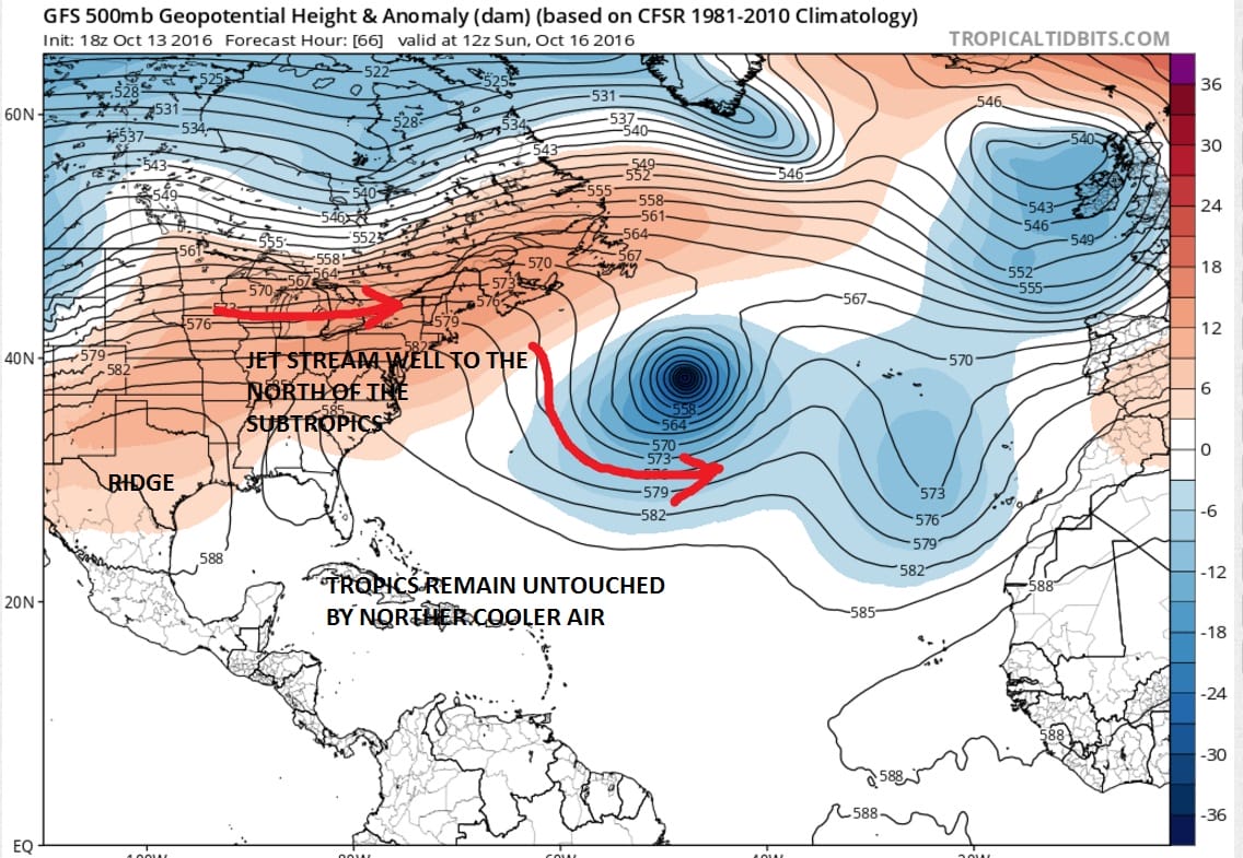
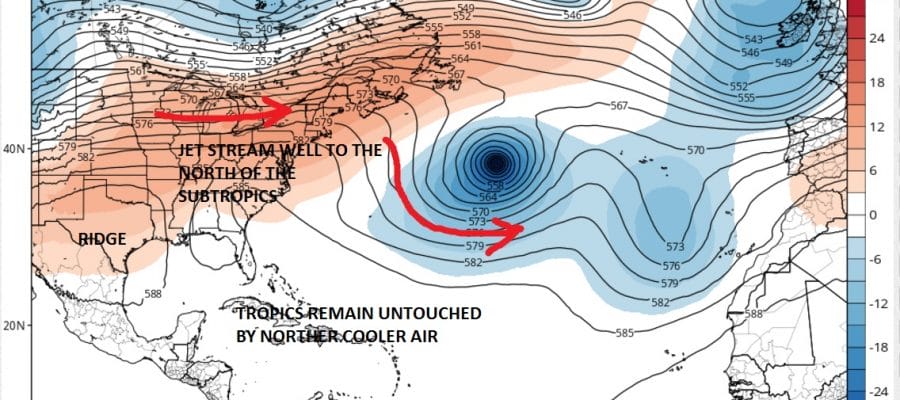
Weather models are all over the place with this idea for later next week. No cold front has penetrated south into the Gulf of Mexico or Florida yet which keeps the tropics pretty much intact and protected from any kind of cooler environment from the north. Secondly is the anticyclonic or high pressure flow across the Southern US which keeps easterlies very active. Add to that several waves coming across from the tropics and you have the seedlings for tropical storms. The question is whether it comes together.
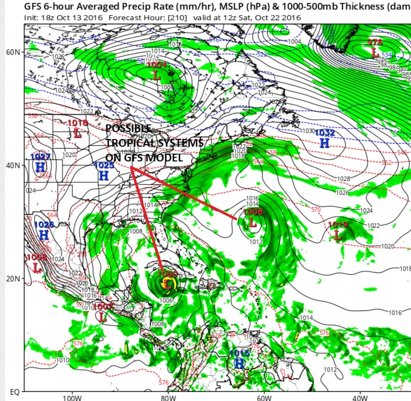
Pressures across the Caribbean particularly the Southern Caribbean are very low. This is probably where something might emerge. The late afternoon GFS run shows this along with something that spins up in the Atlantic. Today’s Canadian is its usual aggressive self spinning up everything in its path. It suggests something forms early next week and heads up the east coast!
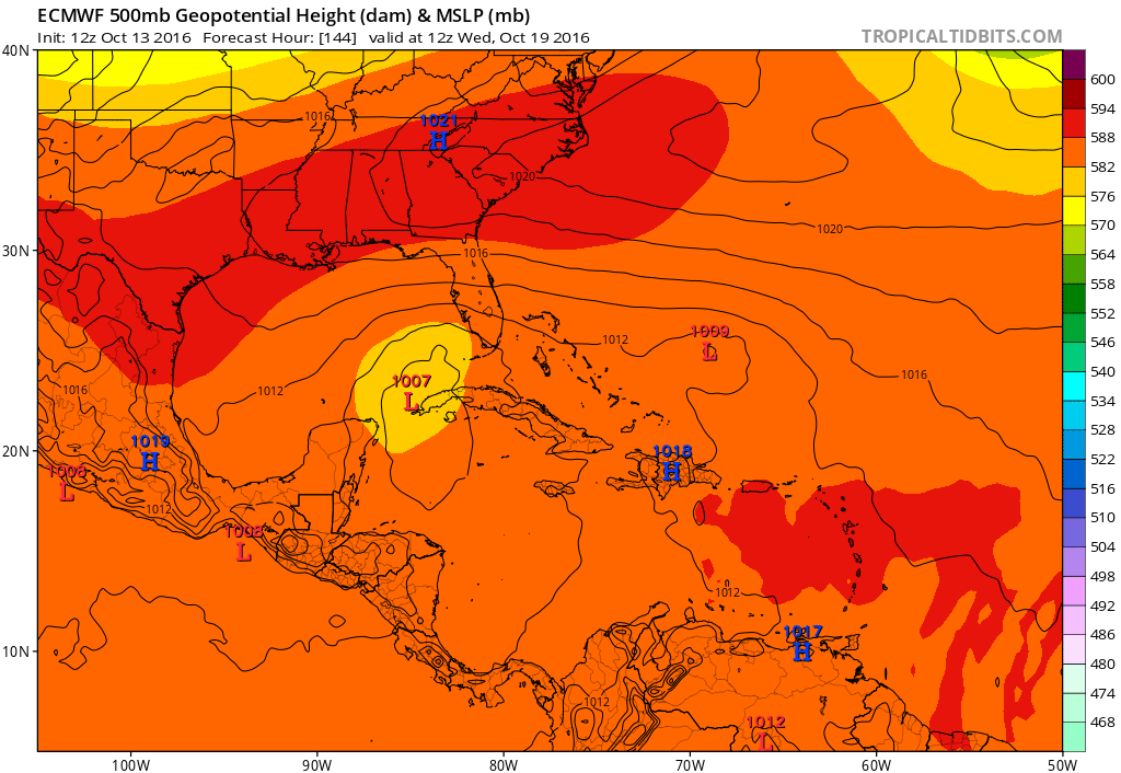
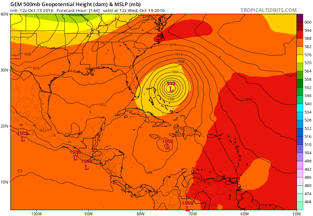
The European on the other hand wants to focus on the Northwest Caribbean and create a tropical storm in the Eastern Gulf of Mexico late next week!
What do we make of all this? Well right now nothing other than watching all this with some interest. Other things going on will make for a more dynamic pattern across the Eastern US late next week at the same time. There is nothing specific we can point to here because solutions are all over the place including the possibility that nothing much happens at all. However it does seem to me that weather models seem to be sensing something is going to happen somewhere. It is probably safe to say that conditions still remain favorable for some sort of tropical development over the next two weeks as activity shifts westward into the more favorable areas for tropical storm formation late in the season. For more on this and what it all may mean, check the latest post from JOESTRADAMUS.
MANY THANKS TO TROPICAL TIDBITS FOR THE WONDERFUL USE OF THE MAPS

MENTION JOE CIOFFI AND GET A 5% DISCOUNT
WINTER 2016-2017 PART 1 OCEAN WATER TEMPERATURES
WINTER 2016-2017 PART 2 ARCTIC SEA ICE AND SIBERIAN SNOW COVER
FiOS1 News Weather Forecast For Long Island
FiOS1 News Weather Forecast For New Jersey
FiOS1 News Weather Forecast For Hudson Valley
NATIONAL WEATHER SERVICE SNOW FORECASTS
LATEST JOESTRADAMUS ON THE LONG RANGE
Weather App

Don’t be without Meteorologist Joe Cioffi’s weather app. It is really a meteorologist app because you get my forecasts and my analysis and not some automated computer generated forecast based on the GFS model. This is why your app forecast changes every 6 hours. It is model driven with no human input at all. It gives you an icon, a temperature and no insight whatsoever.
It is a complete weather app to suit your forecast needs. All the weather information you need is right on your phone. Android or I-phone, use it to keep track of all the latest weather information and forecasts. This weather app is also free of advertising so you don’t have to worry about security issues with your device. An accurate forecast and no worries that your device is being compromised.
Use it in conjunction with my website and my facebook and twitter and you have complete weather coverage of all the latest weather and the long range outlook. The website has been redone and upgraded. Its easy to use and everything is archived so you can see how well Joe does or doesn’t do when it comes to forecasts and outlooks.
Just click on the google play button or the apple store button on the sidebar for my app which is on My Weather Concierge. Download the app for free. Subscribe to my forecasts on an ad free environment for just 99 cents a month.
Get my forecasts in the palm of your hand for less than the cost of a cup of Joe!
![]()

