Hurricane Season 2017 Nears

Hurricane Season 2017 Nears
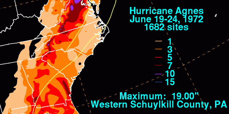
Hurricane Season 2017 begins on June 1st which is just 2 days from now. Nature doesn’t exactly flip a switch on and off when it comes to these things. While the season begins on June 1st, the threat for the East in June tends to be rare. Yes we have seen the odd storm here and there over the years. Probably the one that stands out the most for the Northeast and Middle Atlantic States is Hurricane Agnes in 1972. Agnes actually impacted 15 states and it was a record rainfall producer for parts of Eastern Pennsylvania. Many flood records were set and still stand to this day.
HURRICANE AGNES IMPACT HEAVY RAINFALL


When you look at the satellite photo you can see the cyclone inland and it has the look of what happens when tropical cyclones move into northern latitudes and gain characteristics more typical of non tropical cyclones. The satellite signature was impressive. However this was a rare occurrence.
HURRICANE SEASON 2017 SEA SURFACE TEMPERATURES COMPARED TO AVERAGE
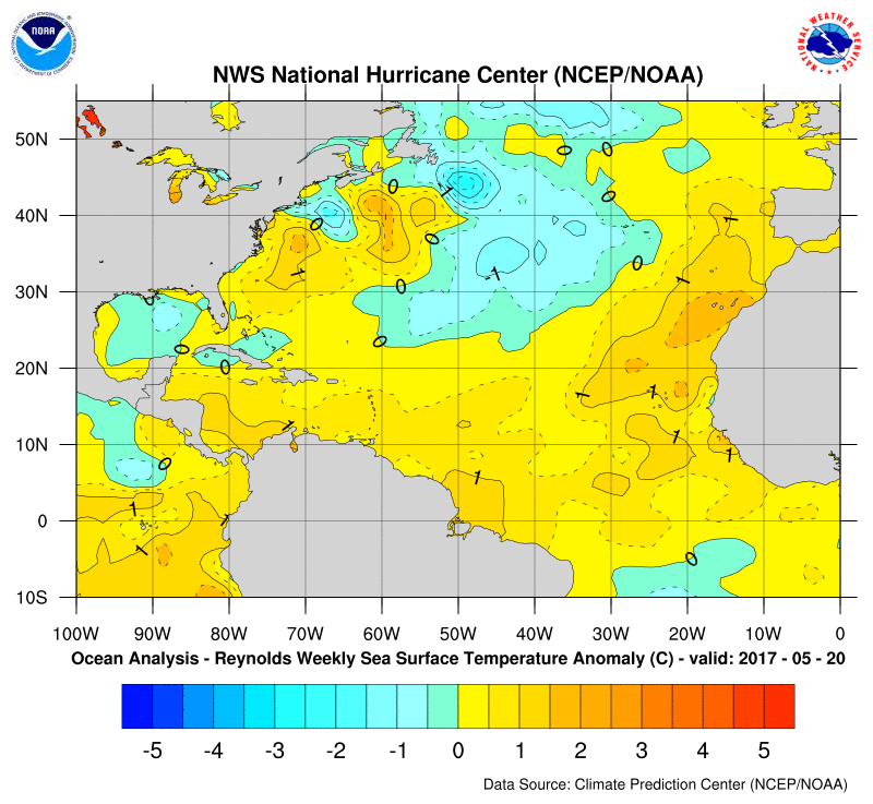
When we look at sea surface temperatures as compared to normal what is remarkable is that over the last few years we have seen large portions of the Atlantic above average by several degrees or more. This has been completely eliminated. In fact it is just about average everywhere across the Atlantic Basin with the exception of the Gulf of Mexico which is running a shade below average. Somehow the large anomalies have all be rectified back to their mean positions for the most part from Greenland to the Equator!
HURRICANE SEASON 2017 SEA SURFACE TEMPERATURES
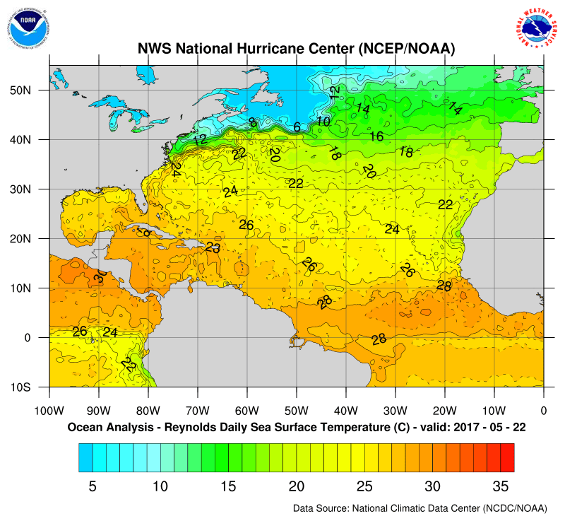
The actual sea surface temperatures continue to rise slowly. 26 Degrees C (79F) is usually the threshhold temperature to support tropical storms Upper level winds this time of year limit the development area to the Western Caribbean and parts of the Southeast Gulf of Mexico at the beginning of June. That development area spreads out somewhat by the end of June.
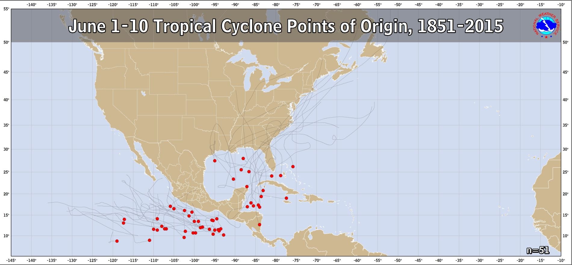
The map above shows the tropical systems that have formed during the first 10 days of June. Right now there is nothing that would suggest that this season would produce an anomaly. Notice that there are tracks of systems that have passed close to or just offshore however these were all in a fairly weakened state.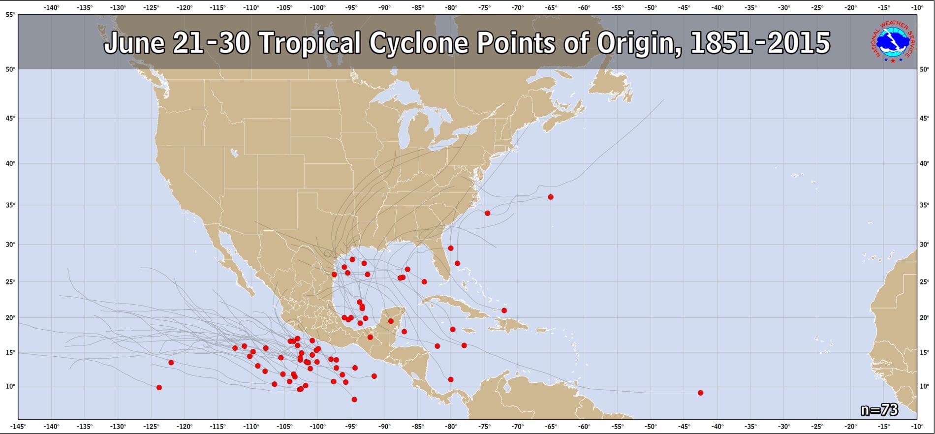
Notice that by the last 10 days of the month the points of orgin begin to spread out. Also there are a few systems that have developed along the East Coast though all the tracks were offshore. Sometimes upper level systems drop down from Canada and “cut off” along the Southeast US Coast. If they sit there long enough they can warm and a tropical cyclone could form from such a set up. With the appearance of blocking lately, this might be something we would have to watch for in the weeks ahead since there could be a tendency for something to separate from the main flow and drop off the coast. However there is nothing at this point that suggests such an event is going to happen.
The bottom line is that June for the Northeast & Middle Atlantic States is not a big threat period. It is August into October when water temperatures reach their peaks that we have to pay closer attention to. Over the coming weeks I will be giving talks on the subject. Click on the links for information on my appearances on Long Island at the Patchogue Medford Library on Wednesday May 31, and at the Sayville Library on Saturday June 3.
MANY THANKS TO TROPICAL TIDBITS FOR THE WONDERFUL USE OF THE MAPS

GET JOE A CIGAR IF YOU LIKE!
LANDSCAPE COMPANIES FOR YOUR SPRING SUMMER FALL NEEDS
LONG ISLAND ROCKLAND COUNTY Connecticut

![]()

ROCKLAND COUNTY TRI STATE SNOW REMOVAL JOHNSTOWN PA


FiOS1 News Weather Forecast For Long Island
FiOS1 News Weather Forecast For New Jersey
FiOS1 News Weather Forecast For Hudson Valley
NATIONAL WEATHER SERVICE SNOW FORECASTS
LATEST JOESTRADAMUS ON THE LONG RANGE
Weather App

Don’t be without Meteorologist Joe Cioffi’s weather app. It is really a meteorologist app because you get my forecasts and my analysis and not some automated computer generated forecast based on the GFS model. This is why your app forecast changes every 6 hours. It is model driven with no human input at all. It gives you an icon, a temperature and no insight whatsoever.
It is a complete weather app to suit your forecast needs. All the weather information you need is right on your phone. Android or I-phone, use it to keep track of all the latest weather information and forecasts. This weather app is also free of advertising so you don’t have to worry about security issues with your device. An accurate forecast and no worries that your device is being compromised.
Use it in conjunction with my website and my facebook and twitter and you have complete weather coverage of all the latest weather and the long range outlook. The website has been redone and upgraded. Its easy to use and everything is archived so you can see how well Joe does or doesn’t do when it comes to forecasts and outlooks.
Just click on the google play button or the apple store button on the sidebar for my app which is on My Weather Concierge. Download the app for free. Subscribe to my forecasts on an ad free environment for just 99 cents a month.
Get my forecasts in the palm of your hand for less than the cost of a cup of Joe!
![]()
