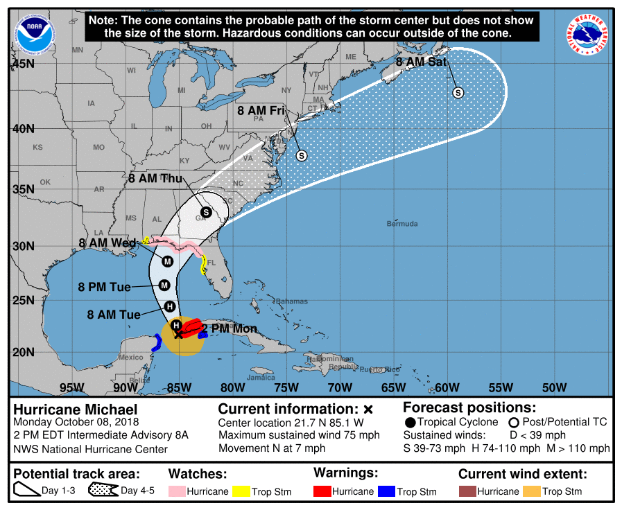
HURRICANE MICHAEL CONTINUES STEADY STRENGTHENING THIS AFTERNOON
HURRICANE WATCHES LIKELY TO BE UPGRADED TO A WARNING TONIGHT OR TUESDAY MORNING
FLORIDA PANHANDLE GREATEST RISK
MICHAEL FORECAST TO MAJOR HURRICANE BEFORE LANDFALL
CENTER OF MICHAEL PASSING NEAR THE WESTERN TIP OF CUBA…
…HEAVY RAINFALL AND STRONG WINDS SPREADING ACROSS WESTERN CUBA…
…RISK OF LIFE-THREATENING STORM SURGE…HEAVY RAINFALL…AND
DANGEROUS WINDS INCREASING FOR THE NORTHEASTERN GULF COAST…
SUMMARY OF 200 PM EDT…1800 UTC…INFORMATION
———————————————-
LOCATION…21.7N 85.1W
ABOUT 20 MI…30 KM SW OF THE WESTERN TIP OF CUBA
ABOUT 145 MI…230 KM NE OF COZUMEL MEXICO
MAXIMUM SUSTAINED WINDS…75 MPH…120 KM/H
PRESENT MOVEMENT…N OR 360 DEGREES AT 7 MPH…11 KM/H
MINIMUM CENTRAL PRESSURE…978 MB…28.88 INCHES
WATCHES AND WARNINGS
——————–
CHANGES WITH THIS ADVISORY:
None
SUMMARY OF WATCHES AND WARNINGS IN EFFECT:
A Hurricane Warning is in effect for…
* The Cuban province of Pinar del Rio
A Tropical Storm Warning is in effect for…
* The Cuban province of the Isle of Youth
* The coast of Mexico from Tulum to Cabo Catoche, including Cozumel
A Storm Surge Watch is in effect for…
* Navarre Florida to Anna Maria Island Florida, including Tampa Bay
A Hurricane Watch is in effect for…
* Alabama-Florida border to Suwannee River Florida
A Tropical Storm Watch is in effect for…
* Suwannee River to Anna Maria Island Florida, including Tampa Bay
* Alabama-Florida border to the Mississippi-Alabama border
GULF OF MEXICO SATELLITE

Recon reports this morning show as well as the satellite loops all show that Michael continues to organize and strengthen. The pressure continues to drop at about 1-2 mb per hour and is now down to 978 millibars. Upper level winds continue to relax and with Michael forecast to move northward over very warm waters in the Gulf of Mexico, it appears that the hurricane will at least make it to category 2 and could possibly reach major hurricane status before landfall on Wednesday on the Florida panhandle.
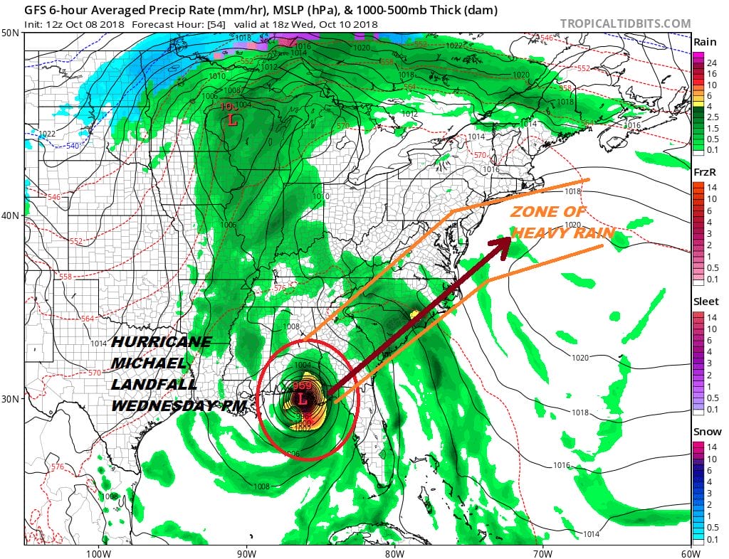
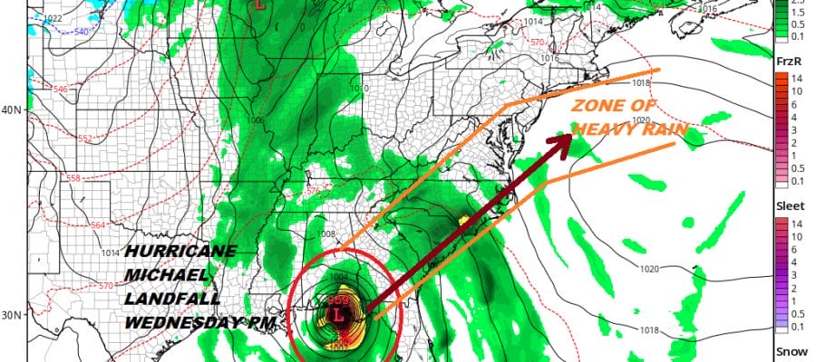
The biggest risks for us at this point will be rain that will be produced by a cold front approaching coupled with Michael in whatever form, either tropical storm or a system transitioning into a post tropical or extratropical storm. As Michael gains latitude we will see the heavy rains shifting to north and northwest of the storm track. The good news is that this system will be moving along and there is no danger of it stalling out. It becomes a matter of dealing with 8 to 12 hours of heavy rains.
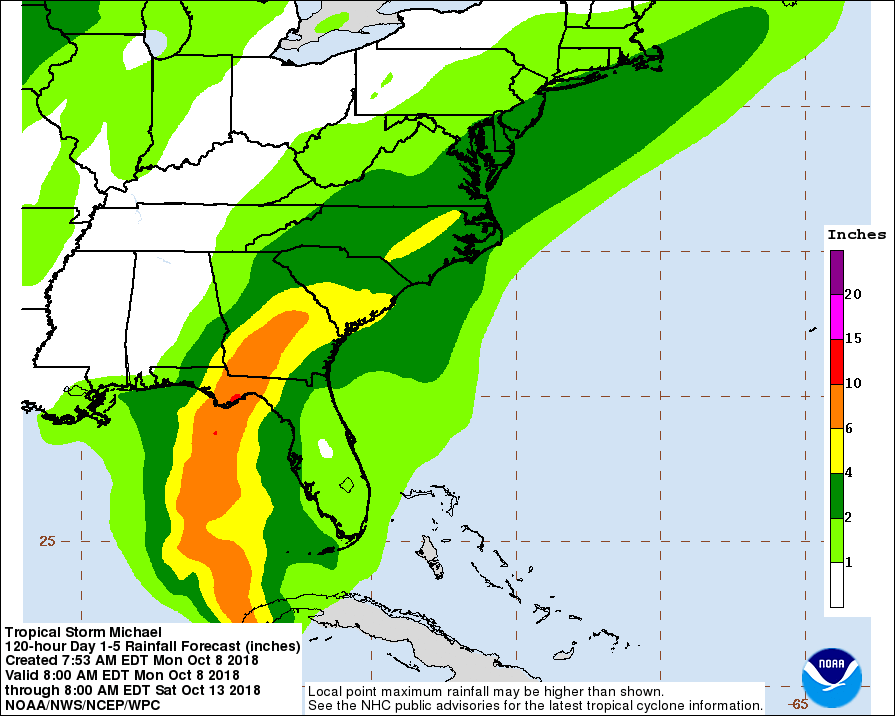
Above is a map of early rainfall estimates from Michael as it moves northeastward through the Eastern Carolinas and then off the Virginia coast to the northeast. Areas from South Central Pennsylvania to Southern New England will be on the edge of the 2 to 4 inch rainfall amounts with 1 to 2 inches north and west of that area. Nothing of consequence happens here until Thursday. Warm and humid conditions will continue into Thursday. The storm center will move to the northeast and once it passes, much cooler and drier air comes in for later Friday and for the weekend. We will continue to monitor the changes in the track and we will be adjusting the area of heavy rainfall depending on any track changes. The further southeast track would mean less rain, while one further inland means more rain.
Join us tonight for a live youtube livestream at 7pm with guest DR Judah Cohen to discuss the upcoming Winter of 2018-2019 along with the latest on Hurricane Michael.
SUBSCRIBE TO PATREON FOR A WEATHER EXPERIENCE FREE OF ADS, EXCLUSIVE VIDEOS FOR MEMBERS ONLY AND MUCH MORE…STARTS AT $2 A MONTH..MESSAGE ME AT ANY TIME

THANKS TO TROPICAL TIDBITS FOR THE USE OF MAPS
Please consult your local National Weather Service office at weather.gov for the latest information on any tropical or storms or hurricanes that could be a threat to your area. Consult your local government officials regarding action you may need to take to secure life and property
FiOS1 News Weather Forecast For Long Island
FiOS1 News Weather Forecast For New Jersey
FiOS1 News Weather Forecast For Hudson Valley