
Hurricane Matthew Warnings Florida East Coast
THE SUDDEN FORMATION OF TROPICAL STORM NICOLE TO THE EAST OF HURRICANE MATTHEW COULD CREATE A RATHER BIZZARE SCENARIO
For those of you who were asking me about Tropical Storm Nicole and if it meant anything…well guess what. YOU HAVE YOUR ANSWER!
And boy it is quite BIZZARE!
Hurricane Matthew Warnings Florida East Coast
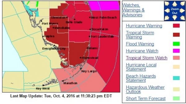

The National Hurricane Center has raised Hurricane Warnings for a portion of the Florida East Coast from just north of Miami to just north of Vero Beach with a Hurricane Watch extending northward to just north of Daytona Beach. Hurricane Matthew is now moving off the east coast of Cuba and heading into the Bahamas where Hurricane Warnings are in effect as well. While the hurricane has weakened slightly it still remains a formidable Category 3 hurricane with maximum sustained winds of 130 mph.

Once Matthew clears Cuba and begins its north north west path it will be moving over ocean water temperatures that are above 86 degrees. The upper air shearing environment remains very low and conditions are favorable for gradual strengthening. Hurricane Matthew could easily attain category 4 status again as it approaches the Florida east coast.
HURRICANE MATTHEW GFS MODEL CLICK TO ANIMATE
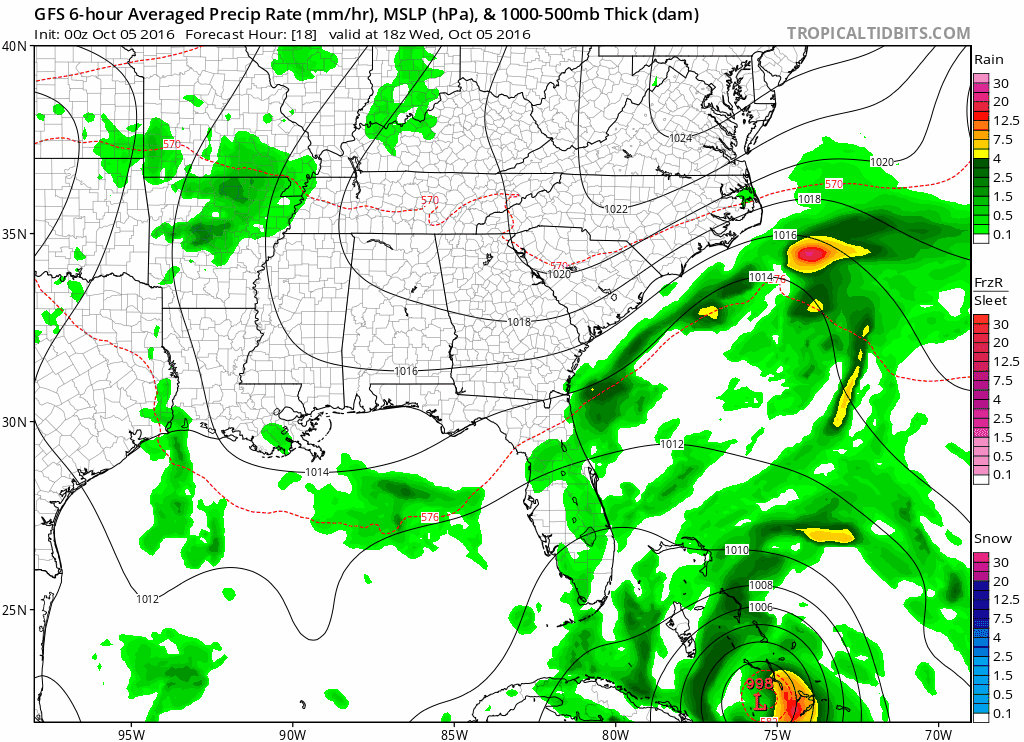
The new GFS model run shifted further left again to where it brings the hurricane right on the coast in the northern portion of the warning area before edging it just offshore again southeast of Jacksonville.
HURRICANE MATTHEW GFS UPPER AIR FORECAST SATURDAY MORNING
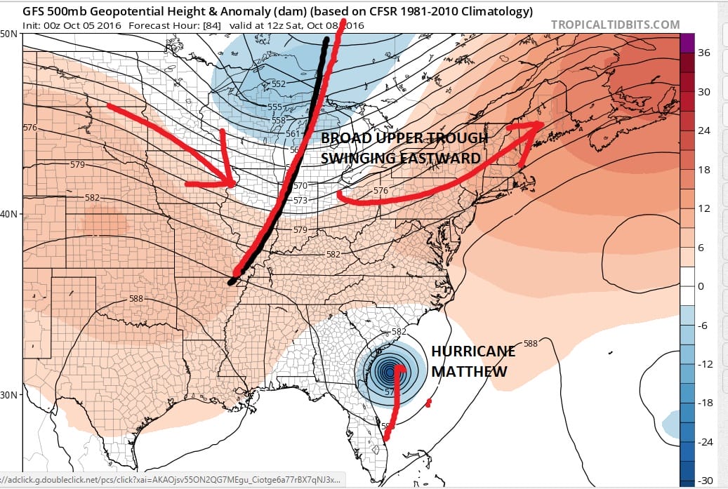
The structure of this upper air trough on the GFS model is completely different then what was depicted over the last week or so. The lack of depth and broadness of the jet stream would suggest that Matthew would only be able to get so far north before being ejected out to the east northeast. In fact trough is so broad that it may not be able to pick up Matthew at all. To the east of Matthew is Tropical Storm Nicole which may also block it from moving east. The European and UKMET modelS today depicted Matthew moving east and then turning south and then southwest and finding its way back to the Florida east coast early next week. The GFS may not be quite there yet but the European and UKMET models may be on to something. It appears the threat to the Northeast and Middle Atlantic states has been reduced to almost zero on this particular run. Obviously we would need confirmations from the other models but it stands to reason that if they showed it this afternoon, they will likely show something similar overnight when those models arrive. This is beginning to turn into something utterly bizzare. We will be putting up a second post to address the issues of the northeast and the future of Hurricane Matthew in a separate post and video shortly.
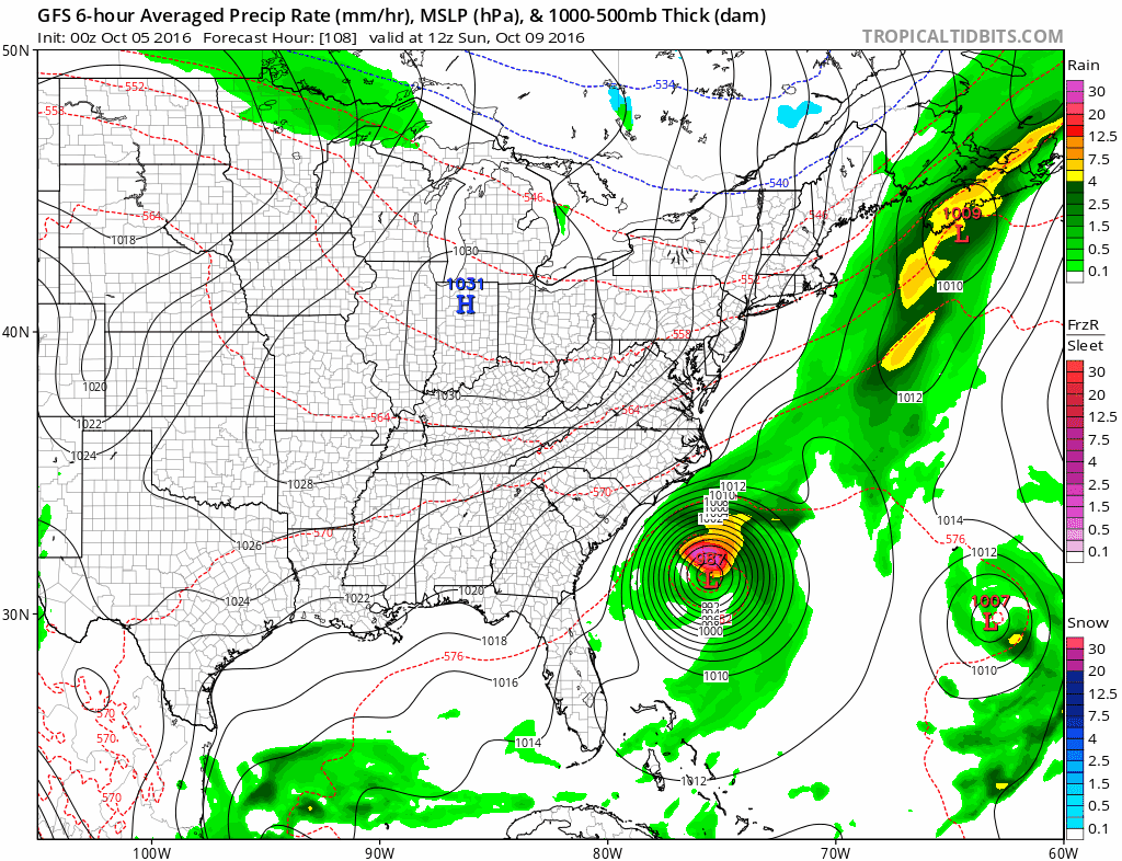
GFS HURRICANE MATTHEW CLICK TO ANIMATE
BULLETIN
HURRICANE MATTHEW ADVISORY NUMBER  28
NWS NATIONAL HURRICANE CENTER MIAMI FL       AL142016
1100 PM EDT TUE OCT 04 2016

...THE EYE OF POWERFUL HURRICANE MATTHEW MOVING OFF OF THE
NORTHEASTERN COAST OF CUBA...
...HURRICANE AND TROPICAL STORM WARNINGS ISSUED FOR FLORIDA...


SUMMARY OF 1100 PM EDT...0300 UTC...INFORMATION
-----------------------------------------------
LOCATION...20.4N 74.4W
ABOUT 55 MI...85 KM ENE OF GUANTANAMO CUBA
ABOUT 20 MI...30 KM NW OF THE EASTERN TIP OF CUBA
MAXIMUM SUSTAINED WINDS...130 MPH...215 KM/H
PRESENT MOVEMENT...N OR 350 DEGREES AT 8 MPH...13 KM/H
MINIMUM CENTRAL PRESSURE...950 MB...28.06 INCHES


WATCHES AND WARNINGS
--------------------
CHANGES WITH THIS ADVISORY:

The Hurricane Watches from Golden Beach to Sebastian Inlet, and for
Lake Okeechobee, have been changed to Hurricane Warnings. The
Hurricane Watch has been extended northward to the Flagler/Volusia
county line. The Tropical Storm Watch from Seven Mile Bridge to
Golden Beach has been changed to a Tropical Storm Warning, and
Tropical Storm Warnings have been added from Chokoloskee to Ocean
Reef, and for Florida Bay.

SUMMARY OF WATCHES AND WARNINGS IN EFFECT:

A Hurricane Warning is in effect for...
* Haiti
* Cuban provinces of Guantanamo, Santiago de Cuba, Holguin, Granma,
and Las Tunas
* Southeastern Bahamas, including the Inaguas, Mayaguana, Acklins,
Crooked Island, Long Cay, and Ragged Island
* Central Bahamas, including Long Island, Exuma, Rum Cay,
San Salvador, and Cat Island
* Northwestern Bahamas, including the Abacos, Andros Island,
Berry Islands, Bimini, Eleuthera, Grand Bahama Island, and
New Providence
* North of Golden Beach to Sebastian Inlet
* Lake Okeechobee

A Hurricane Watch is in effect for...
* Cuban province of Camaguey
* North of Sebastian Inlet to the Flagler/Volusia county line

A Tropical Storm Warning is in effect for...
* Dominican Republic from Barahona westward to the border with Haiti
* Turks and Caicos Islands
* Chokoloskee to Golden Beach
* Florida Keys from Seven Mile Bridge eastward
* Florida Bay

A Tropical Storm Watch is in effect for...
* Dominican Republic from Puerto Plata westward to the border with
Haiti

Interests elsewhere in the Florida Peninsula and the Florida Keys
should monitor the progress of Matthew.

For storm information specific to your area in the United
States, including possible inland watches and warnings, please
monitor products issued by your local National Weather Service
forecast office. For storm information specific to your area outside
the United States, please monitor products issued by your national
meteorological service.


DISCUSSION AND 48-HOUR OUTLOOK
------------------------------
At 1100 PM EDT (0300 UTC), radar data from Guantanamo, Cuba, along
with reports from an Air Force Reserve Hurricane Hunter aircraft,
indicate that the eye of Hurricane Matthew was located near latitude
20.4 North, longitude 74.4 West. Matthew is moving toward the north
near 8 mph (13 km/h), and this general motion is expected to
continue tonight. A turn toward the north-northwest is expected on
Wednesday, followed by a northwest turn Wednesday night. Matthew
will be moving through the Bahamas through Thursday, and is
expected to be very near the east coast of Florida by Thursday
evening.

Maximum sustained winds have decreased to near 130 mph (215 km/h)
with higher gusts, but Matthew remains a category 4 hurricane on the
Saffir-Simpson Hurricane Wind Scale.  Some fluctuations in intensity
are possible during the next couple of days, but Matthew is expected
to remain a powerful hurricane through at least Thursday night.

Hurricane-force winds extend outward up to 45 miles (75 km) from the
center and tropical-storm-force winds extend outward up to 175 miles
(280 km).

The minimum central pressure recently reported by reconnaissance
aircraft was 950 mb (28.06 inches).


HAZARDS AFFECTING LAND
----------------------
WIND:  Hurricane conditions are still affecting portions of Haiti.
Hurricane conditions are likely occuring over eastern Cuba, and will
begin in the southeastern Bahamas by Wednesday morning, the central
Bahamas on Wednesday, and the northwestern Bahamas Wednesday night.

Tropical storm conditions are expected to continue spreading across
the remainder of Haiti, eastern Cuba and the southeastern Bahamas
tonight, and should reach the central and northwestern Bahamas on
Wednesday, making outside preparations difficult or dangerous.
Tropical storm conditions are still occurring in portions the
Dominican Republic within the warning area, and these conditions
will spread northward into the Turks and Caicos Islands tonight.

Hurricane conditions are possible in the hurricane watch areas in
Cuba tonight with tropical storm conditions possible later tonight.

Hurricane conditions are expected within the hurricane warning area
in Florida by late Thursday, with tropical storm conditions expected
by early Thursday. Tropical storm condition should reach the
tropical storm warning area in Florida by early Thursday.

RAINFALL:  Matthew is expected to produce total rainfall amounts in
the following areas:

Southern Haiti and southwestern Dominican Republic...15 to 25
inches, isolated 40 inches
Eastern Cuba and northwestern Haiti...8 to 12 inches, isolated
20 inches
Eastern Jamaica...4 to 6 inches, isolated 12 inches
The Bahamas...8 to 12 inches, isolated 15 inches
Turks and Caicos Islands...2 to 5 inches, isolated 8 inches
Northeastern Haiti and the Northern Dominican Republic...1 to 3
inches, isolated 5 inches
Western Jamaica...1 to 2 inches, isolated 3 inches
Upper Florida Keys northward to coastal east-central Florida....4 to
7 inches, isolated 10 inches
Middle to Lower Florida Keys....1 to 3 inches, isolated 5 inches

Life-threatening flash floods and mudslides are likely in southern
and northwestern Haiti, the southwestern Dominican Republic, and
eastern Cuba.

STORM SURGE:  The combination of a dangerous storm surge and large
and destructive waves could raise water levels by as much as the
following amounts above normal tide levels...

Southern Coast of Cuba east of Cabo Cruz...7 to 11 feet
South Coast of Haiti...7 to 10 feet
Northern Coast of Cuba east of Camaguey...4 to 6 feet
Gulf of Gonave in Haiti...3 to 5 feet
The Bahamas...10 to 15 feet

The water could reach the following heights above ground if the peak
surge occurs at the time of high tide...

North Palm Beach to the Flagler/Volusia county line...3 to 5 ft

Surge-related flooding depends on the relative timing of the surge
and the tidal cycle, and can vary greatly over short distances.
Large waves generated by Matthew will cause water rises to occur
well in advance of and well away from the track of the center.

The combination of a dangerous storm surge and the tide will cause
normally dry areas near the coast to be flooded by rising waters
moving inland from the shoreline.  There is a danger of
life-threatening inundation during the next 36 hours along the
Florida east coast from North Palm Beach to the Sebastian Inlet.
There is the possibility of life-threatening inundation during the
next 48 hours from Sebastian Inlet to the Flagler/Volusia county
line. For a depiction of areas at risk, please see the Prototype
National Weather Service Storm Surge Watch/Warning Graphic.  For
information specific to your area, please see products issued by
your local National Weather Service forecast office.

The Prototype Storm Surge Watch/Warning Graphic is a depiction of
areas that would qualify for inclusion under a storm surge watch or
warning currently under development by the National Weather Service
and planned for operational use in 2017.  The Prototype Graphic is
available at hurricanes.gov.

SURF:  Swells generated by Matthew will continue to affect portions
of the coasts of Hispaniola, Jamaica, eastern Cuba, and the
Caribbean coastline of Central America during the next few days.
Swells from Matthew are also affecting portions of the Bahamas.
These swells are likely to cause life-threatening surf
and rip current conditions.  Please consult products from your local
weather office.
WINTER 2016-2017 PART 1 OCEAN WATER TEMPERATURES
WINTER 2016-2017 PART 2 ARCTIC SEA ICE AND SIBERIAN SNOW COVER
WINTER 2016-2017 PART 3 NEW JERSEY PREVIEW
WINTER 2016-2017 PART 4 EASTERN PENNSYLVANIA PREVIEW
FiOS1 News Weather Forecast For Long Island
FiOS1 News Weather Forecast For New Jersey
FiOS1 News Weather Forecast For Hudson Valley
NATIONAL WEATHER SERVICE SNOW FORECASTS
LATEST JOESTRADAMUS ON THE LONG RANGE
Weather App

Don’t be without Meteorologist Joe Cioffi’s weather app. It is really a meteorologist app because you get my forecasts and my analysis and not some automated computer generated forecast based on the GFS model. This is why your app forecast changes every 6 hours. It is model driven with no human input at all. It gives you an icon, a temperature and no insight whatsoever.
It is a complete weather app to suit your forecast needs. All the weather information you need is right on your phone. Android or I-phone, use it to keep track of all the latest weather information and forecasts. This weather app is also free of advertising so you don’t have to worry about security issues with your device. An accurate forecast and no worries that your device is being compromised.
Use it in conjunction with my website and my facebook and twitter and you have complete weather coverage of all the latest weather and the long range outlook. The website has been redone and upgraded. Its easy to use and everything is archived so you can see how well Joe does or doesn’t do when it comes to forecasts and outlooks.
Just click on the google play button or the apple store button on the sidebar for my app which is on My Weather Concierge. Download the app for free. Subscribe to my forecasts on an ad free environment for just 99 cents a month.
Get my forecasts in the palm of your hand for less than the cost of a cup of Joe!
![]()
![]()