Hurricane Matthew Pounding Georgia South Carolina Coasts
Hurricane Matthew Pounding Georgia South Carolina Coasts
Heavy Rains 6 Inches or More
Strong Winds Along The Coast
Hurricane Matthew continues moving northward parallel and just offshore the Georgia South Carolina coast. Satellite loops and radars indicate that Matthew continues to becoming slowly less organized. It no longer has the appearance of an intense hurricane. The cloud shield is spreading out. The rains with Matthew continue to spread inland and west of the circulation center. This is creating a less concentrated area of strong winds like it had when it moved up the Florida coast. However it also means that gales have spread further inland. Winds along the coast are running 40 to 50 mph with higher gusts as of midnight.

Three local radar views below show the western edge of the eye very close to shore again. You can see the extent of the rain and this is why 6 inches or more of rain is likely to fall and some areas could receive 10 inches of rain before Matthew moves away later Saturday and Saturday night.

The eye is visible on the radar views but notice that the southeastern quadrant is completely open. This is a sign that the character of Hurricane Matthew is slowly changing though it is still a tropical storm.


HURRICANE MATTHEW FRIDAY 11PM ADVISORY
BULLETIN
HURRICANE MATTHEW ADVISORY NUMBER  40
NWS NATIONAL HURRICANE CENTER MIAMI FL       AL142016
1100 PM EDT FRI OCT 07 2016

...EYE OF HURRICANE MATTHEW CONTINUING NORTHWARD JUST OFF OF THE
COAST OF GEORGIA...
...STORM SURGE FLOODING CONTINUES IN FLORIDA AND GEORGIA...


SUMMARY OF 1100 PM EDT...0300 UTC...INFORMATION
-----------------------------------------------
LOCATION...31.2N 80.5W
ABOUT 70 MI...115 KM SSE OF SAVANNAH GEORGIA
ABOUT 115 MI...185 KM SSW OF CHARLESTON SOUTH CAROLINA
MAXIMUM SUSTAINED WINDS...105 MPH...165 KM/H
PRESENT MOVEMENT...N OR 10 DEGREES AT 12 MPH...19 KM/H
MINIMUM CENTRAL PRESSURE...948 MB...28.00 INCHES


WATCHES AND WARNINGS
--------------------
CHANGES WITH THIS ADVISORY:

The Hurricane Warning is changed to a Tropical Storm Warning from
north of Flagler/Volusia county line to Fernandina Beach, Florida.

SUMMARY OF WATCHES AND WARNINGS IN EFFECT:

A Hurricane Warning is in effect for...
* North of Fernandina Beach to Surf City

A Hurricane Watch is in effect for...
* North of Surf City to Cape Lookout

A Tropical Storm Warning is in effect for...
* North of Surf City to Duck
* Pamlico and Albemarle Sounds
* north of Flagler/Volusia county line to Fernandina Beach

For storm information specific to your area, including possible
inland watches and warnings, please monitor products issued by your
local National Weather Service forecast office.


DISCUSSION AND 48-HOUR OUTLOOK
------------------------------
At 1100 PM EDT (0300 UTC), the center of Hurricane Matthew was
located near latitude 31.2 North, longitude 80.5 West. Matthew is
moving toward the north near 12 mph (19 km/h) and this motion is
expected to continue tonight.  A turn toward toward the
north-northeast and then to the northeast is expected on Saturday.
On the forecast track, the center of Matthew will continue to move
near or over the coast of Georgia through tonight, near or over the
coast of South Carolina later tonight and Saturday, and near the
coast of southern North Carolina on Saturday night.

Maximum sustained winds are near 105 mph (165 km/h) with higher
gusts.  Although weakening is forecast during the next 48 hours,
Matthew is expected to remain a hurricane while the center is near
the coast.

Hurricane-force winds extend outward up to 60 miles (95 km) from the
center and tropical-storm-force winds extend outward up to 185 miles
(295 km).  NOAA buoy 41008 located off of the Georgia coast recently
reported sustained winds of 54 mph (87 km/h) and a wind gust of 72
mph (115 km/h).

The estimated minimum central pressure is 948 mb (28.00 inches).


HAZARDS AFFECTING LAND
----------------------
WIND:  Hurricane and tropical storm conditions are expected to
continue over the warning area in Georgia tonight, and spread
northward elsewhere within the warning area through Saturday.
Tropical storm conditions in northeastern Florida should subside
tonight.

Residents in high-rise buildings should be aware that the winds at
the top of a 30-story building will be, on average, about one
Saffir-Simpson category higher than the winds near the surface.

Hurricane conditions are possible within the Hurricane Watch and
Tropical Storm Warning area in North Carolina by Saturday night or
Sunday morning, with tropical storm conditions expected by Saturday
morning.

STORM SURGE:  The combination of a dangerous storm surge, the tide,
and large and destructive waves will cause normally dry areas near
the coast to be flooded by rising waters moving inland from the
shoreline.  The water could reach the following heights above ground
if the peak surge occurs at the time of high tide...

Ponte Vedra Beach, Florida, to Edisto Beach, South Carolina,
including portions of the St. Johns River...6 to 9 ft
Edisto Beach, South Carolina to Cape Fear, North Carolina...
5 to 7 ft
Cape Fear to Duck, North Carolina, including portions of the
Pamlico and Albemarle Sounds...2 to 4 ft

The deepest water will occur along the immediate coast in areas of
onshore winds.  Surge-related flooding depends on the relative
timing of the surge and the tidal cycle, and can vary greatly over
short distances.  Large waves generated by Matthew will cause water
rises to occur well in advance of and well away from the track of
the center.  For information specific to your area, please see
products issued by your local National Weather Service forecast
office.

There is a danger of life-threatening inundation during the next 36
hours along the Florida northeast coast, the Georgia coast, the
South Carolina coast, and the North Carolina coast from the
Volusia/Brevard county line, Florida, to Cape Fear, North Carolina.
There is the possibility of life-threatening inundation during the
next 48 hours from north of Cape Fear to Duck, North Carolina. For
a depiction of areas at risk, please see the Prototype National
Weather Service Storm Surge Watch/Warning Graphic. For information
specific to your area, please see products issued by your local
National Weather Service forecast office.

The Prototype Storm Surge Watch/Warning Graphic is a depiction of
areas that would qualify for inclusion under a storm surge watch or
warning currently under development by the National Weather Service
and planned for operational use in 2017.  The Prototype Graphic is
available at hurricanes.gov.

RAINFALL:  Matthew is expected to produce total rain accumulations
of 8 to 12 inches over the Atlantic coast of the United States from
eastern Georgia into eastern North Carolina and southeast
Virginia...with possible isolated maximum amounts of 15 inches.
This rainfall may result in life threatening flooding and flash
flooding. Rains will continue to diminish across northern Florida
tonight  with additional amounts up to an inch possible.

TORNADOES:  A tornado or two remains possible near the South
Carolina coast for the remainder of tonight.

SURF:  Swells generated by Matthew will continue to affect portions
of the Bahamas and the east coast of Florida during the next few
days, and will spread northward along the southeast U.S. coast
through the weekend.  These swells will likely cause life-
threatening surf and rip current conditions. Please consult products
from your local weather office.
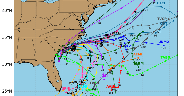
Hurricane Matthew Model Outlook
When we look at the models tonight the solutions are all over the place ranging from moving it northeastward from the Carolinas and taking it to the Canadian Maritime Provinces to merging it with the cold front moving offshore and turning it post tropical to orchestrating the loop southward to even being absorbed by Tropical Storm Nicole. The spaghetti plots of the hurricane models reflect this confusion
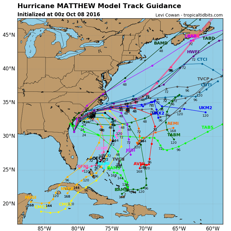
We are going to stick with the global model solutions which is to take Matthew on a clockwise loop southward and then southwestward though where it ultimately winds up is anyone’s guess at this point.
WINTER WEATHER OUTLOOK VIDEOS
In case you missed them I’ve been previewing the upcoming winter in a series of posts and videos. Here are the first 2. More will be coming along. Links to the latest posts are below.
NEW JERSEY
LONG ISLAND AND NEARBY
WINTER 2016-2017 PART 3 NEW JERSEY
WINTER 2016-2017 PART 1 OCEAN WATER TEMPERATURES
WINTER 2016-2017 PART 2 ARCTIC SEA ICE AND SIBERIAN SNOW COVER
FiOS1 News Weather Forecast For Long Island
FiOS1 News Weather Forecast For New Jersey
FiOS1 News Weather Forecast For Hudson Valley
NATIONAL WEATHER SERVICE SNOW FORECASTS
LATEST JOESTRADAMUS ON THE LONG RANGE

Weather App

Don’t be without Meteorologist Joe Cioffi’s weather app. It is really a meteorologist app because you get my forecasts and my analysis and not some automated computer generated forecast based on the GFS model. This is why your app forecast changes every 6 hours. It is model driven with no human input at all. It gives you an icon, a temperature and no insight whatsoever.
It is a complete weather app to suit your forecast needs. All the weather information you need is right on your phone. Android or I-phone, use it to keep track of all the latest weather information and forecasts. This weather app is also free of advertising so you don’t have to worry about security issues with your device. An accurate forecast and no worries that your device is being compromised.
Use it in conjunction with my website and my facebook and twitter and you have complete weather coverage of all the latest weather and the long range outlook. The website has been redone and upgraded. Its easy to use and everything is archived so you can see how well Joe does or doesn’t do when it comes to forecasts and outlooks.
Just click on the google play button or the apple store button on the sidebar for my app which is on My Weather Concierge. Download the app for free. Subscribe to my forecasts on an ad free environment for just 99 cents a month.
Get my forecasts in the palm of your hand for less than the cost of a cup of Joe!
