Hurricane Matthew Florida Bound
Hurricane Matthew Florida Bound
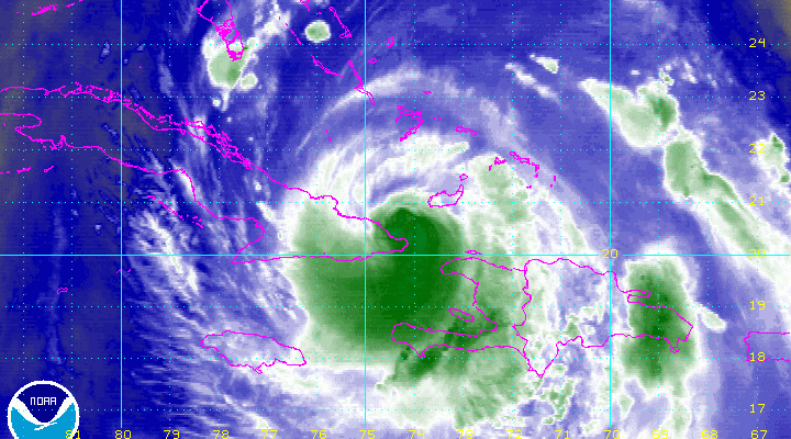
Hurricane Warnings remain posted for the East Coast of Florida as Hurricane Matthew now begins its move through the Bahamas. Hurricane Warnings are up for the entire island chain.

Trip across the mountainous terrain of Eastern Cuba took a toll on Hurricane Matthew strength wise but not by much and not unexpected. As it tracks northwestward very warm ocean waters and a low wind shear environment could cause Matthew to strengthen again before reaching the Northern Bahamas and Southern Florida.

Water Vapor imagery shows the core of the hurricane is still rather impressive as it begins to reorganize again. It could strengthen back to a category 4 hurricane.
BULLETIN
HURRICANE MATTHEW INTERMEDIATE ADVISORY NUMBER  29A
NWS NATIONAL HURRICANE CENTER MIAMI FL       AL142016
800 AM EDT WED OCT 05 2016

...HURRICANE MATTHEW HEADING FOR THE CENTRAL AND NORTHWESTERN
BAHAMAS...


SUMMARY OF 800 AM EDT...1200 UTC...INFORMATION
----------------------------------------------
LOCATION...21.5N 74.9W
ABOUT 45 MI...85 KM ENE OF CABO LUCRECIA CUBA
ABOUT 115 MI...185 KM S OF LONG ISLAND BAHAMAS
MAXIMUM SUSTAINED WINDS...115 MPH...185 KM/H
PRESENT MOVEMENT...NNW OR 345 DEGREES AT 10 MPH...17 KM/H
MINIMUM CENTRAL PRESSURE...964 MB...28.47 INCHES


WATCHES AND WARNINGS
--------------------
CHANGES WITH THIS ADVISORY:

None.

SUMMARY OF WATCHES AND WARNINGS IN EFFECT:

A Hurricane Warning is in effect for...
* Haiti
* Cuban provinces of Guantanamo, Santiago de Cuba, Holguin, Granma,
and Las Tunas
* Southeastern Bahamas, including the Inaguas, Mayaguana, Acklins,
Crooked Island, Long Cay, and Ragged Island
* Central Bahamas, including Long Island, Exuma, Rum Cay,
San Salvador, and Cat Island
* Northwestern Bahamas, including the Abacos, Andros Island,
Berry Islands, Bimini, Eleuthera, Grand Bahama Island, and
New Providence
* North of Golden Beach to Sebastian Inlet
* Lake Okeechobee

A Hurricane Watch is in effect for...
* Cuban province of Camaguey
* North of Sebastian Inlet to the Fernandina Beach

A Tropical Storm Warning is in effect for...
* Dominican Republic from Barahona westward to the border with Haiti
* Turks and Caicos Islands
* Chokoloskee to Golden Beach
* Florida Keys from Seven Mile Bridge eastward
* Florida Bay

A Tropical Storm Watch is in effect for...
* Dominican Republic from Puerto Plata westward to the border with
Haiti

Interests elsewhere in the Florida Peninsula and the Florida Keys
should monitor the progress of Matthew.

For storm information specific to your area in the United States,
including possible inland watches and warnings, please monitor
products issued by your local National Weather Service forecast
office. For storm information specific to your area outside
the United States, please monitor products issued by your national
meteorological service.


DISCUSSION AND 48-HOUR OUTLOOK
------------------------------
At 800 AM EDT (1200 UTC), the center of Hurricane Matthew was
located near latitude 21.5 North, longitude 74.9 West. Matthew is
moving toward the north-northwest near 10 mph (17 km/h).  This
motion is expected to continue today, followed by a northwestward
turn tonight.  On this track, Matthew will be moving across the
Bahamas through Thursday, and is expected to be very near the east
coast of Florida by Thursday evening.

Maximum sustained winds are near 115 mph (185 km/h) with higher
gusts.  Matthew is a category 3 hurricane on the Saffir-Simpson
Hurricane Wind Scale.  Some slight strengthening is forecast during
the next couple of days.

Hurricane-force winds extend outward up to 40 miles (65 km) from
the center, and tropical-storm-force winds extend outward up to 160
miles (260 km).

The minimum central pressure reported by NOAA and Air Force
Hurricane Hunter planes was 964 mb (28.47 inches).

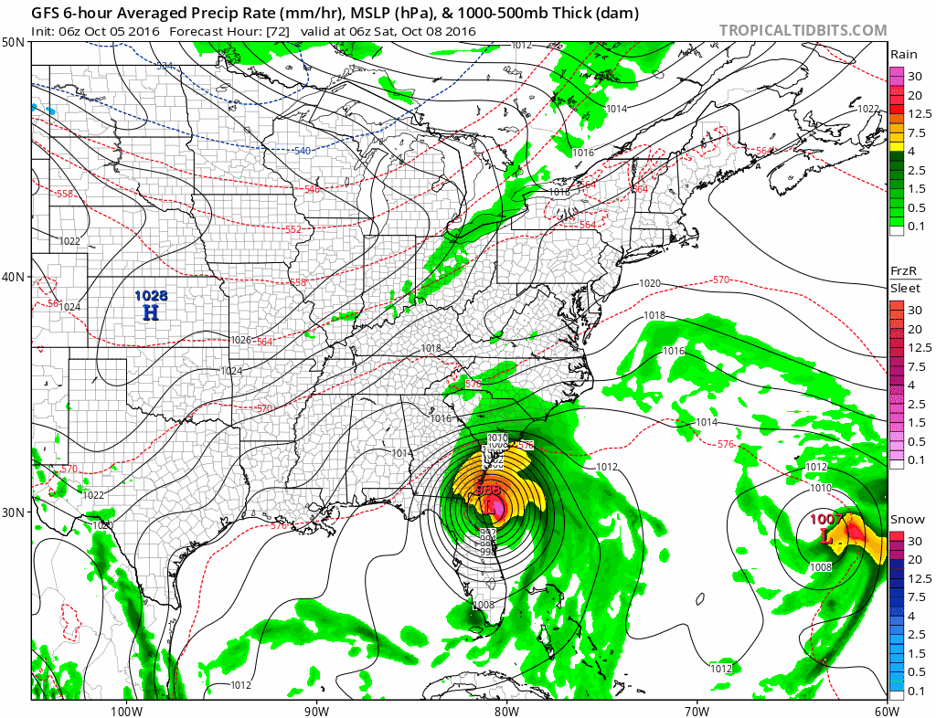
The Tropical storm you see in the lower right corner of the satellite loop is Tropical Storm Nicole which may wind up blocking Hurricane Matthew over the weekend from moving out to sea and forcing it to do a clockwise loop off the Southeast Coast of the US. Several models bring Matthew back to the Bahamas and Florida for a second round of weather next week but we will explore that possibility later today.
Locally we are starting out the day with some low clouds along the coast but just inland of the coast it is partly to mostly sunny and we would expect areas that have low clouds to see some developing sunshine later today and be no worse than partly sunny before too long with temperatures in the 60s to lower 70s where there is more sunshine today.
Radars are quiet with no rain and they will remain so for the rest of the work week.

T he next 2 days we will see some great early October weather with plenty of sunshine and temperatures in the mid to upper 70s. High pressure to the north actually settles overhead so with no real flow off the ocean, temperatures can move higher.
Now as far as the weekend goes, unless there is a sudden change in the outlook of Hurricane Matthew we may see some just a few clouds as a weather front comes through early Saturday. The front has very little with it. This was the same front and weather system that was supposed to pick up Hurricane Matthew and bring it up the east coast. Instead it isn’t even going to pick it up at all! Matthew is setting up to do a bizzare clockwise loop over the next week or so.
Hurricane Matthew Florida Bound GFS FORECAST
CLICK TO ANIMATE
Hurricane Matthew Florida Bound GFS FORECAST
CLICK TO ANIMATE
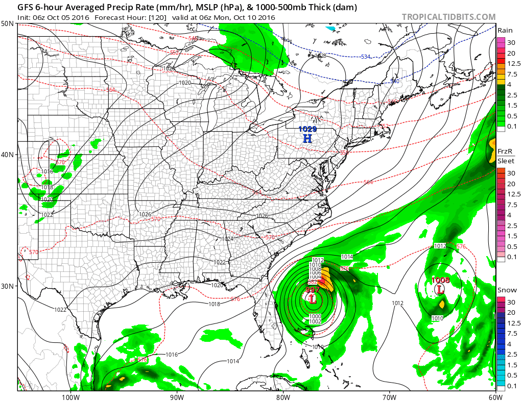
If this is correct and it is supported by the other global models (though it is not supported necessarily by the hurricane models) then our weather will be great through much if not all of next week with lots of sunshine. As it stands for this weekend, we see temperatures in the low to mid 70s Saturday and in the much cooler 60s on Sunday with no rain right through the weekend!
WINTER WEATHER OUTLOOK VIDEOS
In case you missed them I’ve been previewing the upcoming winter in a series of posts and videos. Here are the first 2. More will be coming along. Links to the latest posts are below.
NEW JERSEY
LONG ISLAND AND NEARBY
WINTER 2016-2017 PART 3 NEW JERSEY
WINTER 2016-2017 PART 1 OCEAN WATER TEMPERATURES
WINTER 2016-2017 PART 2 ARCTIC SEA ICE AND SIBERIAN SNOW COVER
FiOS1 News Weather Forecast For Long Island
FiOS1 News Weather Forecast For New Jersey
FiOS1 News Weather Forecast For Hudson Valley
NATIONAL WEATHER SERVICE SNOW FORECASTS
LATEST JOESTRADAMUS ON THE LONG RANGE

Weather App

Don’t be without Meteorologist Joe Cioffi’s weather app. It is really a meteorologist app because you get my forecasts and my analysis and not some automated computer generated forecast based on the GFS model. This is why your app forecast changes every 6 hours. It is model driven with no human input at all. It gives you an icon, a temperature and no insight whatsoever.
It is a complete weather app to suit your forecast needs. All the weather information you need is right on your phone. Android or I-phone, use it to keep track of all the latest weather information and forecasts. This weather app is also free of advertising so you don’t have to worry about security issues with your device. An accurate forecast and no worries that your device is being compromised.
Use it in conjunction with my website and my facebook and twitter and you have complete weather coverage of all the latest weather and the long range outlook. The website has been redone and upgraded. Its easy to use and everything is archived so you can see how well Joe does or doesn’t do when it comes to forecasts and outlooks.
Just click on the google play button or the apple store button on the sidebar for my app which is on My Weather Concierge. Download the app for free. Subscribe to my forecasts on an ad free environment for just 99 cents a month.
Get my forecasts in the palm of your hand for less than the cost of a cup of Joe!

MENTION JOE CIOFFI AND GET A 5% DISCOUNT


