HURRICANE MATTHEW CATEGORY 5 WINDS 160 MPH

HURRICANE MATTHEW CATEGORY 5 WINDS 160 MPH
HURRICANE WATCH FOR JAMAICA
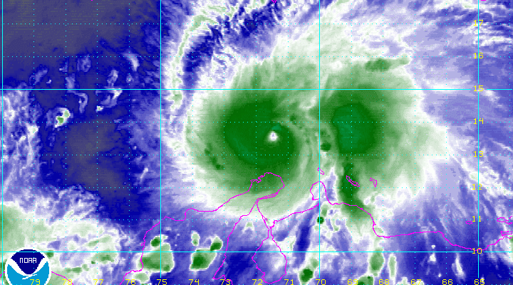
Reports from an Air Force Reconnaissance plane indicate that Hurricane Matthew has strengthened to a category 5 hurricane. It is the first category 5 hurricane in the Atlantic Basin since Hurricane Felix in 2007. It is remarkable that this system went from a category 1 hurricane last night to a category 5 hurricane in a little over 24 hours. It has been intensifying at a rate of 2 to 3 millibars per hour. No model showed Matthew achieving this intensity at this stage of the hurricane’s life cycle
URNT12 KNHC 010203 CCA
VORTEX DATA MESSAGE   AL142016
A. 01/01:25:00Z
B. 13 deg 20 min N
  072 deg 04 min W
C. 700 mb 2612 m
D. 138 kt
E. 277 deg 5 nm
F. 024 deg 130 kt
G. 280 deg 8 nm
H. 944 mb
I. 10 C / 3094 m
J. 21 C / 3051 m
K. 13 C / NA
L. CLOSED
M. C12
N. 12345 / 7
O. 0.02 / 1 nm
P. AF303 0914A MATTHEW            OB 14 CCA
MAX OUTBOUND AND MAX FL WIND 133 KT 001 / 9 NM 01:30:00Z
CNTR DROPSONDE SFC WIND 095 / 18 KT
;
This is the most recent report from the Air Force showed flight level winds of 133 knots and a measured sustained wind of 138 knots. Hurricane Matthew strengthened from a category 1 to a category 5 hurricane in less than 36 hours.
BULLETIN
HURRICANE MATTHEW ADVISORY NUMBER  12
NWS NATIONAL HURRICANE CENTER MIAMI FL       AL142016
1100 PM EDT FRI SEP 30 2016

...MATTHEW BECOMES A CATEGORY 5 HURRICANE...
...THE STRONGEST HURRICANE IN THE ATLANTIC SINCE FELIX IN 2007...


SUMMARY OF 1100 PM EDT...0300 UTC...INFORMATION
-----------------------------------------------
LOCATION...13.3N 72.3W
ABOUT 80 MI...125 KM NW OF PUNTA GALLINAS COLOMBIA
ABOUT 440 MI...710 KM SE OF KINGSTON JAMAICA
MAXIMUM SUSTAINED WINDS...160 MPH...260 KM/H
PRESENT MOVEMENT...W OR 265 DEGREES AT 7 MPH...11 KM/H
MINIMUM CENTRAL PRESSURE...941 MB...27.79 INCHES


WATCHES AND WARNINGS
--------------------
CHANGES WITH THIS ADVISORY:

None.

SUMMARY OF WATCHES AND WARNINGS IN EFFECT:

A Hurricane Watch is in effect for...
* Jamaica

A Tropical Storm Warning is in effect for...
* Colombia/Venezuela border to Riohacha

A Tropical Storm Watch is in effect for...
* Haiti from the southern border with the Dominican Republic to
Port-Au-Prince

A Hurricane Watch means that hurricane conditions are possible
within the watch area.  A watch is typically issued 48 hours before
the anticipated first occurrence of tropical-storm-force winds,
conditions that make outside preparations difficult or dangerous.

A Tropical Storm Warning means that tropical storm conditions are
expected somewhere within the warning area, in this case in the
next 12 hours.

A Tropical Storm Watch means that tropical storm conditions are
possible within the watch area, generally within 48 hours.

Interests elsewhere along the coasts of Venezuela and Colombia and
elsewhere in Hispaniola should monitor the progress of Matthew.
Interests in eastern Cuba should also monitor the progress of
Matthew.

For storm information specific to your area, please monitor
products issued by your national meteorological service.


DISCUSSION AND 48-HOUR OUTLOOK
------------------------------
At 1100 PM EDT (0300 UTC), the eye of Hurricane Matthew was located
near latitude 13.3 North, longitude 72.3 West.  Matthew is moving
just south of due west near 7 mph (11 km/h).  A turn toward the
west-northwest is forecast on Saturday, followed by a turn toward
the northwest on Sunday.  On the forecast track, the center of
Matthew will move north of the Guajira Peninsula tonight, move
across the central Caribbean Sea on Saturday, and be approaching
Jamaica late Sunday.

Data from an Air Force Hurricane Hunter plane indicate that
the maximum sustained winds have increased to near 160 mph (260
km/h) with higher gusts.  Matthew is a category 5 hurricane on the
Saffir-Simpson Hurricane Wind Scale. Some fluctuations in intensity
are possible this weekend, but Matthew is expected to remain a
powerful hurricane through Sunday.

Hurricane-force winds extend outward up to 45 miles (75 km) from the
center and tropical-storm-force winds extend outward up to 205 miles
(335 km).

The minimum central pressure estimated by a reconnaissance aircraft
was 941 mb (27.79 inches).


HAZARDS AFFECTING LAND
----------------------
WIND:  Tropical storm conditions are expected to continue in
portions of the warning area in Colombia overnight.  Hurricane
conditions are possible on Jamaica on Monday, with tropical storm
conditions possible by late Sunday.  Tropical storm conditions are
possible in the watch area in Haiti by late Sunday.

RAINFALL:  Rainfall totals of 2 to 4 inches with isolated higher
amounts are expected over Aruba, Bonaire and Curacao through
Saturday.  Rainfall totals of 2 to 4 inches with isolated higher
amounts are expected along the coast of Colombia from the Venezuelan
border to Riohacha.  Rainfall totals of 1 to 2 inches with isolated
higher amounts are expected along the coast of Venezuela from Coro
to the Colombian border.

Rainfall totals of 10 to 15 inches with isolated maximum amounts of
25 inches are expected across Jamaica and southern and southwestern
Haiti.  These rains may produce life-threatening flash flooding and
mud slides.

SURF:  Swells generated by Matthew are expected to affect portions
of the coasts of Puerto Rico, Hispaniola, Jamaica, Aruba, Bonaire,
Curacao, Venezuela, and Colombia during the next few days.  These
swells are likely to cause life-threatening surf and rip current
conditions.  Please consult products from your local weather office.
Tonight;s GFS model run as begun and we will post an analysis of this on a JOESTRADAMUS post shortly. Here is the previous post from this afternoon.
WINTER 2016-2017 PART 1 OCEAN WATER TEMPERATURES
WINTER 2016-2017 PART 2 ARCTIC SEA ICE AND SIBERIAN SNOW COVER
WINTER 2016-2017 PART 3 NEW JERSEY PREVIEW
WINTER 2016-2017 PART 4 EASTERN PENNSYLVANIA PREVIEW
FiOS1 News Weather Forecast For Long Island
FiOS1 News Weather Forecast For New Jersey
FiOS1 News Weather Forecast For Hudson Valley
NATIONAL WEATHER SERVICE SNOW FORECASTS
LATEST JOESTRADAMUS ON THE LONG RANGE
Weather App

Don’t be without Meteorologist Joe Cioffi’s weather app. It is really a meteorologist app because you get my forecasts and my analysis and not some automated computer generated forecast based on the GFS model. This is why your app forecast changes every 6 hours. It is model driven with no human input at all. It gives you an icon, a temperature and no insight whatsoever.
It is a complete weather app to suit your forecast needs. All the weather information you need is right on your phone. Android or I-phone, use it to keep track of all the latest weather information and forecasts. This weather app is also free of advertising so you don’t have to worry about security issues with your device. An accurate forecast and no worries that your device is being compromised.
Use it in conjunction with my website and my facebook and twitter and you have complete weather coverage of all the latest weather and the long range outlook. The website has been redone and upgraded. Its easy to use and everything is archived so you can see how well Joe does or doesn’t do when it comes to forecasts and outlooks.
Just click on the google play button or the apple store button on the sidebar for my app which is on My Weather Concierge. Download the app for free. Subscribe to my forecasts on an ad free environment for just 99 cents a month.
Get my forecasts in the palm of your hand for less than the cost of a cup of Joe!
![]()
![]()