HURRICANE MATTHEW AIMING FOR JAMAICA & HAITI
HURRICANE MATTHEW AIMING FOR JAMAICA & HAITI
CATEGORY 4 HURRICANE WINDS 140 MPH
150 MPH EUROPEAN & GFS OVERNIGHT FLIPS BACK WESTWARD

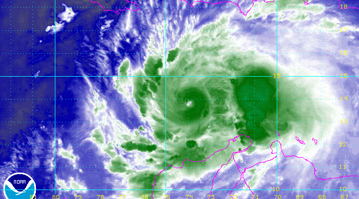
Satellite loops this morning show Hurricane Matthew continues to edge along to the northwest. The eyewall appears ragged. The reconnaissance aircraft this morning found the lowest pressure about the same at 947 millibars. The winds may be coming down just a little bit which is typical for a hurricane that has achieved an extreme amount of strength. But it should be noted that the winds here achieved category 5 status but from a standpoint of pressure it reached a category 4. The old criteria required both pressure and wind standards to be met. Now it is only wind.
URNT12 KNHC 021403
VORTEX DATA MESSAGE   AL142016
A. 02/13:34:50Z
B. 13 deg 58 min N
  074 deg 32 min W
C. 700 mb 2631 m
D. 98 kt
E. 235 deg 8 nm
F. 318 deg 98 kt
G. 235 deg 10 nm
H. 947 mb
I. 9 C / 3046 m
J. 17 C / 3046 m
K. 9 C / NA
L. CLOSED
M. E33/16/12
N. 1234 / 7
O. 0.02 / 1 nm
P. AF303 1314A MATTHEW            OB 16
MAX FL WIND 117 KT 341 / 8 NM 12:16:30Z
MAX OUTBOUND FL WIND 111 KT 054 / 9 NM 13:37:30Z
CNTR DROPSONDE SFC WIND 070 / 4 KT
MAX FL TEMP 21 C 231 / 6 NM FROM FL CNTR
RAGGED EYEWALL
HURRICANE MATTHEW LATEST ADVISORY
BULLETIN
HURRICANE MATTHEW ADVISORY NUMBER  18
NWS NATIONAL HURRICANE CENTER MIAMI FL       AL142016
1100 AM EDT SUN OCT 02 2016

...POWERFUL HURRICANE MATTHEW MEANDERING BUT EXPECTED TO MOVE
NORTHWESTWARD TO NORTHWARD...


SUMMARY OF 1100 AM EDT...1500 UTC...INFORMATION
-----------------------------------------------
LOCATION...14.0N 74.6W
ABOUT 350 MI...565 KM SSW OF PORT AU PRINCE HAITI
ABOUT 310 MI...505 KM SSE OF KINGSTON JAMAICA
MAXIMUM SUSTAINED WINDS...140 MPH...220 KM/H
PRESENT MOVEMENT...W OR 270 DEGREES AT 3 MPH...6 KM/H
MINIMUM CENTRAL PRESSURE...947 MB...27.97 INCHES


WATCHES AND WARNINGS
--------------------
CHANGES WITH THIS ADVISORY:

None.

SUMMARY OF WATCHES AND WARNINGS IN EFFECT:

A Hurricane Warning is in effect for...
* Jamaica
* Haiti
* Cuban provinces of Guantanamo, Santiago de Cuba, Holguin, Granma,
and Las Tunas

A Hurricane Watch is in effect for...
* Cuban province of Camaguey
* Southeastern Bahamas, including the Inaguas, Mayaguana, Acklins,
Crooked Island, Long Cay, and Ragged Island
* Turks and Caicos Islands

A Tropical Storm Warning is in effect for...
* Dominican Republic from Barahona westward to the border with Haiti

A Tropical Storm Watch is in effect for...
* Dominican Republic from Puerto Plata westward to the border with
Haiti

Interests elsewhere in Hispaniola and in the Bahamas should monitor
the progress of Matthew.

A Hurricane Warning means that hurricane conditions are expected
somewhere within the warning area.  A warning is typically issued 36
hours before the anticipated first occurrence of tropical-storm-
force winds, conditions that make outside preparations difficult or
dangerous.  Preparations to protect life and property should be
rushed to completion.

A Hurricane Watch means that hurricane conditions are possible
within the watch area.  A watch is typically issued 48 hours before
the anticipated first occurrence of tropical-storm-force winds,
conditions that make outside preparations difficult or dangerous.

A Tropical Storm Warning means that tropical storm conditions are
expected somewhere within the warning area within 36 hours.

A Tropical Storm Watch means that tropical storm conditions are
possible within the watch area, generally within 48 hours.

For storm information specific to your area, please monitor
products issued by your national meteorological service.


DISCUSSION AND 48-HOUR OUTLOOK
------------------------------
At 1100 AM EDT (1500 UTC), the center of Hurricane Matthew was
located near latitude 14.0 North, longitude 74.6 West.  Matthew is
drifting toward the west near 3 mph (6 km/h).  A turn toward the
northwest is expected later today, followed by a turn toward
the north tonight.  On the forecast track, the center of Matthew
will approach southwestern Haiti and Jamaica on Monday.

Maximum sustained winds are near 140 mph (220 km/h) with higher
gusts.  Matthew is a category 4 hurricane on the Saffir-Simpson
Hurricane Wind Scale.  Some fluctuations in intensity are possible
during the next couple of days, but Matthew is expected to remain a
powerful hurricane through Monday night.

Hurricane-force winds extend outward up to 35 miles (55 km) from the
center and tropical-storm-force winds extend outward up to 205 miles
(335 km).

The minimum central pressure reported by an Air Force Reserve
Hurricane Hunter aircraft is 947 mb (27.96 inches).

HAZARDS AFFECTING LAND
----------------------
WIND:  Hurricane conditions are expected to reach Jamaica and Haiti
on Monday, and eastern Cuba Monday night.  Tropical storm conditions
are expected to first reach Jamaica and Haiti this evening, and
eastern Cuba early Monday, making outside preparations difficult or
dangerous.  Preparations to protect life and property should be
rushed to completion.  Tropical storm conditions are expected along
the southern coast of the Dominican Republic within the warning area
by tonight.

Hurricane conditions are possible in the hurricane watch areas by
late Tuesday with tropical storm conditions possible by early
Tuesday.  Tropical storm conditions are also possible in the
tropical storm watch area in the Dominican Republic by late
Monday.

RAINFALL: Matthew is expected to produce total rain accumulations of
15 to 25 inches over southern Haiti, with possible isolated maximum
amounts of 40 inches.  Across western Haiti, expect total rain
accumulations of 8 to 12 inches with isolated maximum amounts of 16
inches, while northern sections of Haiti can expect lower amounts
in the 1 to 3 inch range with localized maxima near 5 inches.
Matthew is expected to produce total rain accumulations of 10 to 20
inches over eastern Jamaica, the Dominican Republic, and eastern
Cuba, with possible isolated maximum amounts of 25 inches.  This
rainfall will likely produce life-threatening flash floods and mud
slides.

Matthew is expected to produce total rain accumulations of 8 to 10
inches over the southeastern Bahamas, with possible isolated maximum
amounts of 15 inches.  Matthew is expected to produce total rain
accumulations of 2 to 4 inches, with possible isolated maximum
amounts of 6 inches over the Turks and Caicos Islands.

Matthew is expected to produce additional rain accumulations of 1 to
2 inches over Aruba, Curacao, and Bonaire through Sunday.  Matthew
is expected to produce total rain accumulations of 2 to 4 inches
over northern Colombia, northwest Venezuela, and western Jamaica,
with possible isolated maximum amounts of 6 inches.

STORM SURGE:  The combination of a dangerous storm surge and large
and destructive waves could raise water levels by as much as the
following amounts above normal tide levels...

Southern Coast of Cuba east of Cabo Cruz...7 to 11 feet
South Coast of Haiti...7 to 10 feet
Northern Coast of Cuba east of Camaguey...4 to 6 feet
Jamaica...3 to 5 feet
Gulf of Gonave in Haiti...3 to 5 feet
Southern coast of the Dominican Republic...1 to 3 feet

Surge-related flooding depends on the relative timing of the surge
and the tidal cycle, and can vary greatly over short distances.
Large waves generated by Matthew will cause water rises to occur
well in advance of and well away from the track of the center.

SURF:  Swells generated by Matthew will continue to affect portions
of the coasts of Puerto Rico, Hispaniola, Jamaica, Aruba, Bonaire,
Curacao, Venezuela, Colombia, eastern Cuba, and the Caribbean
coastline of Central America during the next few days.  These swells
are likely to cause life-threatening surf and rip current
conditions.  Please consult products from your local weather office.
HURRICANE MATTHEW NEW MODEL CYCLE
The beginning of the new model cycle begins. The NAM at the end of its 84 our range shows Hurricane Matthew coming into view with the trough out west beginning its swing eastward. Will that western trough be strong enough and deep enough to pick Matthew up and move up the east coast?

We are getting to the close to the point where clues should become more obvious. The afternoon model cycle should be very interesting indeed. I have a feeling we may still see more curve balls thrown our way.
WINTER WEATHER OUTLOOK VIDEOS
In case you missed them I’ve been previewing the upcoming winter in a series of posts and videos. Here are the first 2. More will be coming along. Links to the latest posts are below.
NEW JERSEY
LONG ISLAND AND NEARBY
WINTER 2016-2017 PART 3 NEW JERSEY
WINTER 2016-2017 PART 1 OCEAN WATER TEMPERATURES
WINTER 2016-2017 PART 2 ARCTIC SEA ICE AND SIBERIAN SNOW COVER
FiOS1 News Weather Forecast For Long Island
FiOS1 News Weather Forecast For New Jersey
FiOS1 News Weather Forecast For Hudson Valley
NATIONAL WEATHER SERVICE SNOW FORECASTS
LATEST JOESTRADAMUS ON THE LONG RANGE

Weather App

Don’t be without Meteorologist Joe Cioffi’s weather app. It is really a meteorologist app because you get my forecasts and my analysis and not some automated computer generated forecast based on the GFS model. This is why your app forecast changes every 6 hours. It is model driven with no human input at all. It gives you an icon, a temperature and no insight whatsoever.
It is a complete weather app to suit your forecast needs. All the weather information you need is right on your phone. Android or I-phone, use it to keep track of all the latest weather information and forecasts. This weather app is also free of advertising so you don’t have to worry about security issues with your device. An accurate forecast and no worries that your device is being compromised.
Use it in conjunction with my website and my facebook and twitter and you have complete weather coverage of all the latest weather and the long range outlook. The website has been redone and upgraded. Its easy to use and everything is archived so you can see how well Joe does or doesn’t do when it comes to forecasts and outlooks.
Just click on the google play button or the apple store button on the sidebar for my app which is on My Weather Concierge. Download the app for free. Subscribe to my forecasts on an ad free environment for just 99 cents a month.
Get my forecasts in the palm of your hand for less than the cost of a cup of Joe!

MENTION JOE CIOFFI AND GET A 5% DISCOUNT