Hurricane Maria Passing North of Dominican Republic
Hurricane Maria Passing North of Dominican Republic
..MARIA’S LARGE EYE PASSING OFFSHORE OF THE NORTHEASTERN COAST OF
THE DOMINICAN REPUBLIC…
SUMMARY OF 800 AM AST…1200 UTC…INFORMATION
———————————————-
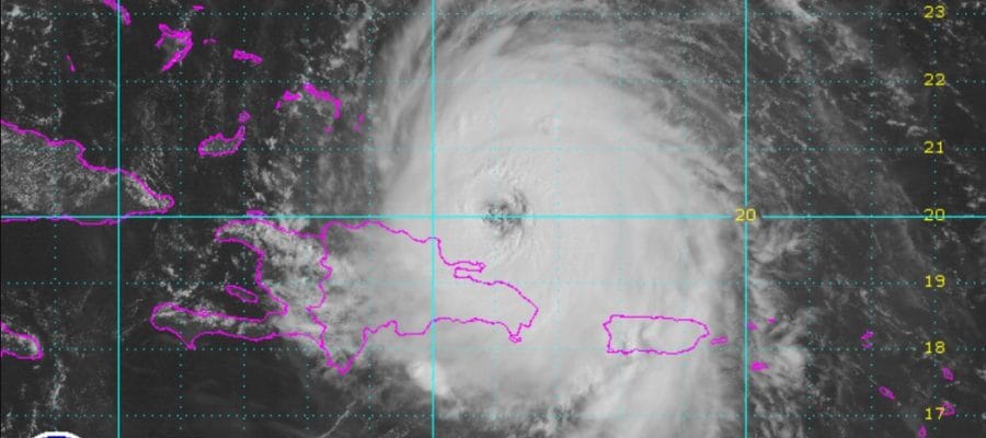
LOCATION…19.9N 68.7W
ABOUT 95 MI…150 KM NNW OF PUNTA CANA DOMINICAN REPUBLIC
ABOUT 190 MI…305 KM SE OF GRAND TURK ISLAND
MAXIMUM SUSTAINED WINDS…115 MPH…185 KM/H
PRESENT MOVEMENT…NW OR 315 DEGREES AT 9 MPH…15 KM/H
MINIMUM CENTRAL PRESSURE…959 MB…28.32 INCHES
WATCHES AND WARNINGS
——————–
CHANGES WITH THIS ADVISORY:
The government of the Bahamas has issued a Tropical Storm Watch for
the central Bahamas.
SUMMARY OF WATCHES AND WARNINGS IN EFFECT:
A Hurricane Warning is in effect for…
* Dominican Republic from Cabo Engano to Puerto Plata
* Turks and Caicos Islands and the Southeastern Bahamas
A Tropical Storm Warning is in effect for…
* Dominican Republic west of Puerto Plata to the northern border of
the Dominican Republic and Haiti
* Dominican Republic west of Cabo Engano to Punta Palenque
A Hurricane Watch is in effect for…
* Dominican Republic from Isla Saona to Cabo Engano
A Tropical Storm Watch is in effect for…
* Central Bahamas
Maria is still recovering from the trip across Puerto Rico the long way. The central pressure rose 55 mb from 906 to 961 millibars. The rough terrain disrupted the circulation and now we have it offshore but close to the north coast of the Dominican Republic which is also disrupting the circulation. Once Maria gets to the north 21 degrees north there should be some more room for intensification. The eye of Maria is apparent though somewhat cloud filled at the moment. The track suggests Maria will move very close to the Turks & Caicos Islands later today and tonight
SATELLITE LOOP

Once Maria makes its close pass to the Turks & Caicos Islands we will see a north northwest to northerly course begin. All the hurricane track models and global models keep Maria well offshore and we hope this to be the case.
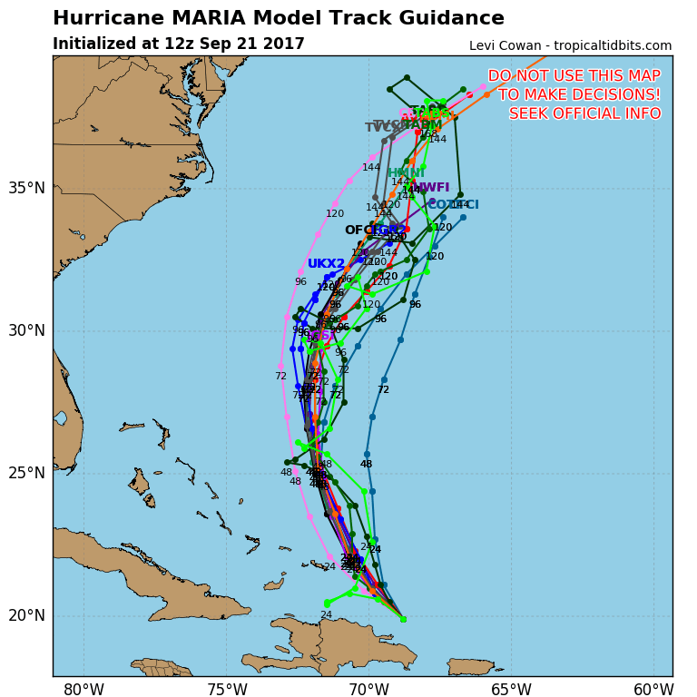
This goes back to yesterday’s model discussion where this all was going to hinge on the impact of Jose off the coast of Southern New England. It appears that Jose by stalling out and decaying in that general area offshore is creating enough of a weakness for Maria to move north and northeastward sooner. The upper trough to the west acts as a kicker and punts Maria out to sea. All the hurricane track model and global model guidance right now lines up pretty well with this idea.
GFS models and all its variations all have Maria on and offshore track. The European & Canadian do so as well. The only way this outlook changes is if Jose remains a viable entity and moves westward and inland into New Jersey and Pennsylvania as some models were showing the last few days. This creates a path for Maria to move up the coast just offshore. Right now we are not seeing any evidence of that happening.

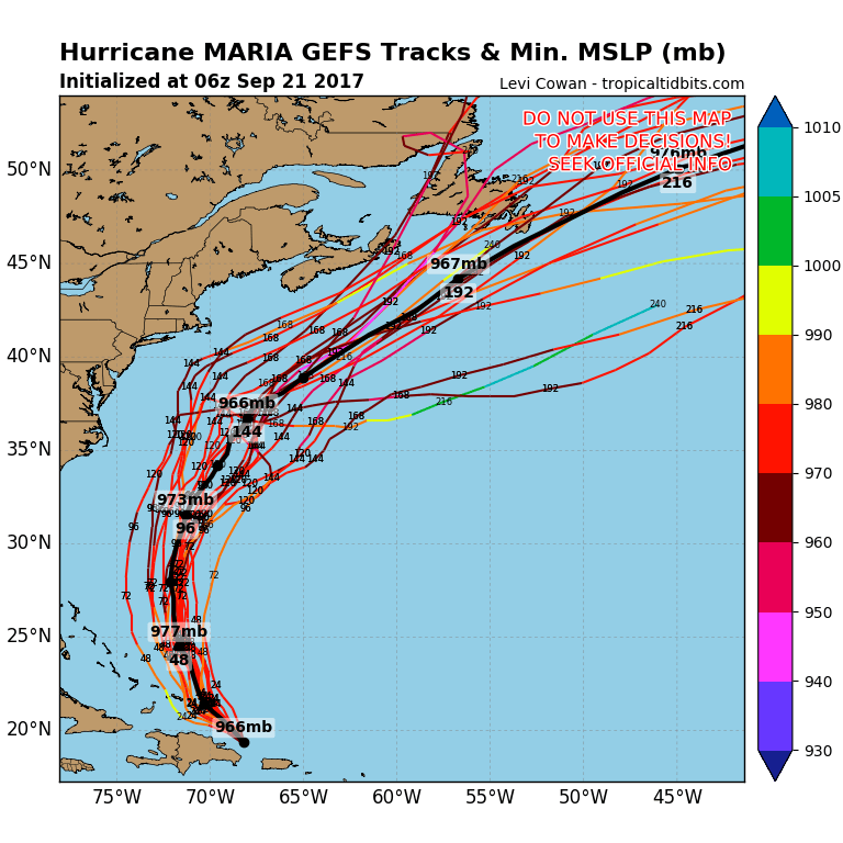
As far as strengthening is concerned one thing Maria will not have in a couple of days is a warm ocean. Up welling from Jose will have created a large area of sub 25 degrees C (77F) water temperatures right over the area where Maria will be passing. While Maria will be travelling over warm waters for the next 48 to 72 hours, eventually it is going to run into this cooler water and have issues. That cold eddy extends south all the way to 25 degrees north in 96 hours.
FiOS1 News Weather Forecast For Long Island
FiOS1 News Weather Forecast For New Jersey
FiOS1 News Weather Forecast For Hudson Valley