Hurricane Maria 75 MPH Hurricane Watches Warnings Expanded
Hurricane Maria 75 MPH Hurricane Watches Warnings Expanded
SUMMARY OF WATCHES AND WARNINGS IN EFFECT:
A Hurricane Warning is in effect for…
* Guadeloupe
* Dominica
* St. Kitts, Nevis, and Montserrat
A Tropical Storm Warning is in effect for…
* Martinique
* Antigua and Barbuda
* Saba and St. Eustatius
* St. Lucia
A Hurricane Watch is in effect for…
* U.S. Virgin Islands
* British Virgin Islands
* Saba and St. Eustatius
* St. Maarten
* St. Martin and St. Barthelemy
* Anguilla
A Tropical Storm Watch is in effect for…
* Barbados
* St. Vincent and the Grenadines
Recon reports from a Air Force plane show that Maria has become a hurricane with 75 mph winds. The storm is compact and growing. All conditions point to a period of rapid intensification is possible over the next few days and there is no reason why Maria cannot become a major hurricane. Water temperatures are very warm, the environment is moist, and there is very little wind shear. Hurricane Watches have been expanded to the US & British Virgin Islands and other islands in the Leewards.
SATELLITE LOOP

…MARIA BECOMES A HURRICANE…
…ADDITIONAL WARNINGS AND WATCHES ISSUED FOR PORTIONS OF THE
LEEWARD ISLANDS…
SUMMARY OF 500 PM AST…2100 UTC…INFORMATION
———————————————-
LOCATION…13.8N 57.5W
ABOUT 140 MI…225 KM ENE OF BARBADOS
ABOUT 275 MI…445 KM ESE OF DOMINICA
MAXIMUM SUSTAINED WINDS…75 MPH…120 KM/H
PRESENT MOVEMENT…WNW OR 285 DEGREES AT 15 MPH…24 KM/H
MINIMUM CENTRAL PRESSURE…982 MB…29.00 INCHES
DISCUSSION AND 48-HOUR OUTLOOK
——————————
At 500 PM AST (2100 UTC), the center of Hurricane Maria was located
by an Air Force Reserve reconnaissance aircraft near latitude 13.8
North, longitude 57.5 West. Maria is moving toward the
west-northwest near 15 mph (24 km/h), and this motion with a
decrease in forward speed is expected through Tuesday. On the
forecast track, the center of Maria will move across the Leeward
Islands Monday night and then over the extreme northeastern
Caribbean Sea on Tuesday.
Reconnaissance data indicate that maximum sustained winds have
increased to near 75 mph (120 km/h) with higher gusts. Additional
strengthening is forecast during the next 48 hours, and Maria could
be near major hurricane intensity when it moves across the Leeward
Islands Monday night.
Hurricane-force winds extend outward up to 15 miles (30 km) from the
center, and tropical-storm-force winds extend outward up to 105
miles (165 km).
The minimum central pressure measured by the aircraft is 982 mb
(29.00 inches).
HAZARDS AFFECTING LAND
———————-
WIND: Hurricane conditions are first expected within portions of
the Leeward Islands by Monday night, with tropical storm conditions
beginning on Monday. Hurricane conditions are possible within the
hurricane watch area by Tuesday, with tropical storm conditions
possible Monday night. Tropical storm conditions are possible in
the tropical storm watch area Monday or Monday night.
STORM SURGE: A dangerous storm surge accompanied by large and
destructive waves will raise water levels by as much as 4 to 6 feet
above normal tide levels near where the center of Maria moves
across the Leeward Islands.
RAINFALL: Maria is expected to produce total rain accumulations of
6 to 12 inches with isolated maximum amounts of 20 inches across the
Leeward Islands, including Puerto Rico and the U.S. and
British Virgin Islands through Wednesday night. Maria is also
expected to produce total rain accumulations of 2 to 4 inches for
the northern and central Windward Islands. In all the above areas,
these rainfall amounts could cause life-threatening flash floods and
mudslides.
SURF: Swells generated by Maria are affecting the Lesser Antilles.
These swells are likely to cause life-threatening surf and rip
current conditions. Please consult products from your local
weather office.
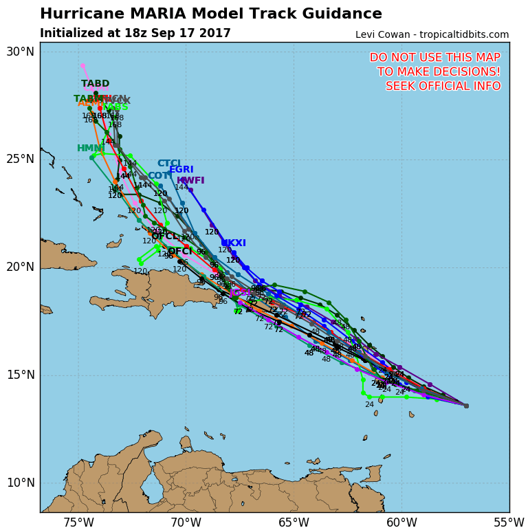
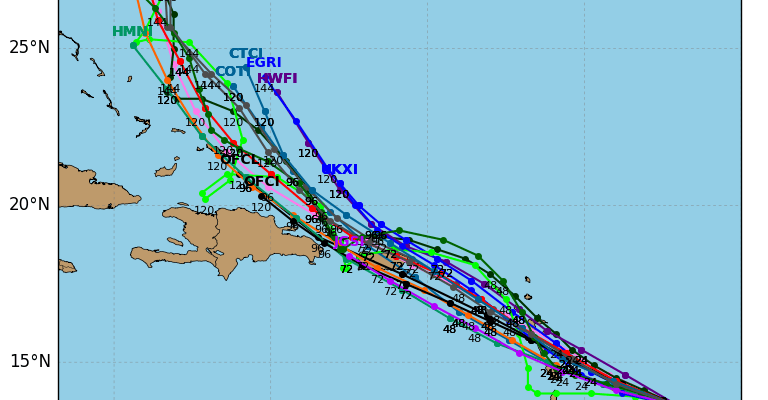
There has been no material change in the hurricane track model guidance today. All the models show Maria impacting just about every island in the Leewards and the possibility of moving directly over the Virgin Islands and Puerto Rico coming in from the East. Most of the models do begin to veer Maria northward but coming very close to the North Shore of the Dominican Republic. Longer term Maria will move west northwest and its future impact to the United States will depend in large part to what Jose does. Jose is forecast to loop around and head back southwestward late in the week. This could create a weakness along the East Coast and an opening for Maria to eventually move northward. However this is far in the land of long range speculation at this point.
LOCAL RADAR MIAMI FLORIDA
 GET JOE A CIGAR IF YOU LIKE

FiOS1 News Weather Forecast For Long Island
FiOS1 News Weather Forecast For New Jersey
FiOS1 News Weather Forecast For Hudson Valley