Hurricane Maria 120 MPH Category 3 Intensifying Rapidly
Hurricane Maria 120 MPH Category 3 Intensifying Rapidly
SUMMARY OF WATCHES AND WARNINGS IN EFFECT:
A Hurricane Warning is in effect for…
* Guadeloupe
* Dominica
* St. Kitts, Nevis, and Montserrat
* Martinique
* St. Lucia
* U.S. Virgin Islands
* British Virgin Islands
A Tropical Storm Warning is in effect for…
* Antigua and Barbuda
* Saba and St. Eustatius
* St. Maarten
* Anguilla
A Hurricane Watch is in effect for…
* Puerto Rico, Vieques, and Culebra
* Saba and St. Eustatius
* St. Maarten
* St. Martin and St. Barthelemy
* Anguilla
A Tropical Storm Watch is in effect for…
* Barbados
* St. Vincent and the Grenadines
SATELLITE LOOP

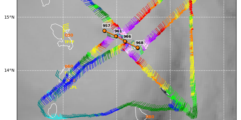
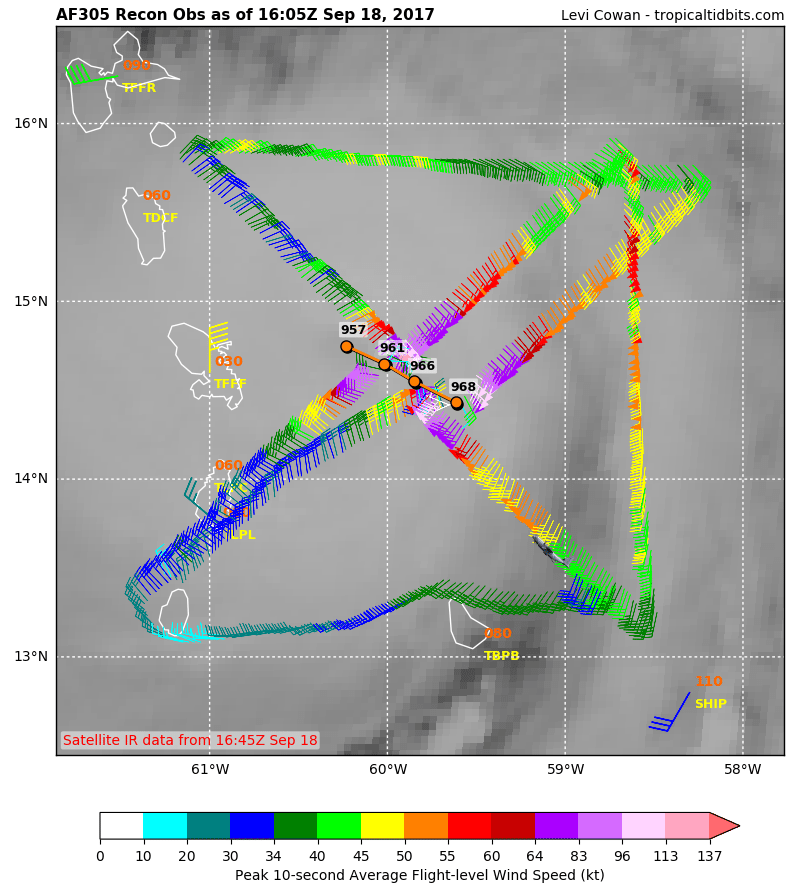
Hurricane Maria wasted absolutely no time in becoming a major hurricane and the eye of Maria will be working its way across the Leeward Islands this afternoon and evening. The eye is closing in on the island of Domenica and will pass just north of the island of Martinique. The latest recon mission found a 9 millibar pressure drop in 3 hours which is off the wall intensification. Maria could possibly reach category 4 status in short order unless an eye wall replacement cycle gets underway. The risk for a direct pass over the Virgin Islands and Puerto Rico is increasing.
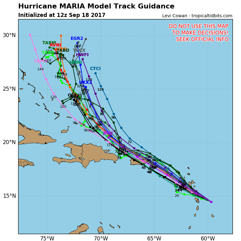
Hurricane track models as well as the global models have Maria raking most of the Leeward Islands and then taking dead aim to the Virgin Islands and Puerto Rico. The track forecasts make for a very close pass to the Domincan Republic later this week but this of course could shift further south given the experience of Hurricane Irma.
..MARIA RAPIDLY INTENSIFIES INTO A MAJOR HURRICANE…
…THE EYE IS EXPECTED TO MOVE THROUGH THE LEEWARD ISLANDS LATE THIS
AFTERNOON OR THIS EVENING…
SUMMARY OF 1100 AM AST…1500 UTC…INFORMATION
———————————————–
LOCATION…14.7N 60.1W
ABOUT 60 MI…95 KM E OF MARTINIQUE
ABOUT 95 MI…150 KM ESE OF DOMINICA
MAXIMUM SUSTAINED WINDS…120 MPH…195 KM/H
PRESENT MOVEMENT…WNW OR 285 DEGREES AT 10 MPH…17 KM/H
MINIMUM CENTRAL PRESSURE…959 MB…28.32 INCHES
DISCUSSION AND 48-HOUR OUTLOOK
——————————
At 1100 AM AST (1500 UTC), the center of Hurricane Maria was located
near latitude 14.7 North, longitude 60.1 West. Maria is moving
toward the west-northwest near 10 mph (17 km/h), and this motion
with some decrease in forward speed is expected through Tuesday
night. On the forecast track, the center of Maria will move across
the Leeward Islands late today and tonight, over the extreme
northeastern Caribbean Sea Tuesday and Tuesday night, and approach
Puerto Rico and the Virgin Islands on Wednesday.
Reports from an Air Force Reserve Hurricane Hunter aircraft indicate
that maximum sustained winds have increased to near 120 mph
(195 km/h) with higher gusts. Maria is a category 3 hurricane on
the Saffir-Simpson Hurricane Wind Scale. Additional rapid
strengthening is forecast during the next 48 hours, and Maria is
expected to be a dangerous major hurricane as it moves through the
Leeward Islands and the northeastern Caribbean Sea.
Hurricane-force winds extend outward up to 15 miles (30 km) from the
center and tropical-storm-force winds extend outward up to 125 miles
(205 km).
The minimum central pressure estimated from the Hurricane Hunter
aircraft data is 959 mb (28.32 inches).
HAZARDS AFFECTING LAND
———————-
WIND: Hurricane conditions are first expected within portions of
the Leeward Islands by late today, with tropical storm conditions
beginning during the next few hours. Hurricane conditions should
spread through the remainder of the hurricane warning area tonight
through Tuesday night. Hurricane conditions are possible within the
hurricane watch area Tuesday through Wednesday, with tropical
storm conditions possible later today or tonight. Tropical storm
conditions are possible in the tropical storm watch area through
tonight.
STORM SURGE: A dangerous storm surge accompanied by large and
destructive waves will raise water levels by as much as 6 to 9 feet
above normal tide levels in the hurricane warning area near where
the center of Maria moves across the Leeward Islands and the
British Virgin Islands.
The combination of a dangerous storm surge and the tide will cause
normally dry areas near the coast to be flooded by rising waters
moving inland from the shoreline. The water is expected to reach
the following heights above ground if the peak surge occurs at the
time of high tide…
Puerto Rico and the U.S. Virgin Islands…6 to 9 ft
The deepest water will occur along the immediate coast near and to
the north and east of the landfall location, where the surge will be
accompanied by large and destructive waves. Surge-related
flooding depends on the relative timing of the surge and the tidal
cycle, and can vary greatly over short distances. For information
specific to your area, please see products issued by your local
National Weather Service forecast office.
RAINFALL: Maria is expected to produce total rain accumulations of
6 to 12 inches with isolated maximum amounts of 20 inches across the
central and southern Leeward Islands, and the U.S. and British
Virgin Islands through Wednesday night. Rainfall amounts of 6 to 12
inches with isolated maximum amounts of 25 inches are expected
across Puerto Rico. Maria is also expected to produce total rain
accumulations of 2 to 4 inches with isolated maximum amounts of 8
inches over the remaining northern Leeward Islands from Barbuda to
Anguilla, eastern portions of the Dominican Republic, as well as the
Windward Islands and Barbados. Rainfall on all of these islands
could cause life-threatening flash floods and mudslides.
FiOS1 News Weather Forecast For Long Island
FiOS1 News Weather Forecast For New Jersey
FiOS1 News Weather Forecast For Hudson Valley