
Satellite loops continue to show better organization and Hurricane Joaquin has top winds now of 80 mph as it continues on a west southwest course. Look closely at the center and you can actually pick out the high cloud tops developing around a well defined core. An eye is likely to form soon as the hurricane continues on a slow strengthening trend.

...JOAQUIN STRENGTHENS SOME MORE AS IT MOVES SOUTHWESTWARD TOWARD
THE CENTRAL BAHAMAS...


SUMMARY OF 1100 AM EDT...1500 UTC...INFORMATION
-----------------------------------------------
LOCATION...24.7N 72.6W
ABOUT 215 MI...345 KM ENE OF THE CENTRAL BAHAMAS
MAXIMUM SUSTAINED WINDS...80 MPH...130 KM/H
PRESENT MOVEMENT...SW OR 230 DEGREES AT 6 MPH...9 KM/H
MINIMUM CENTRAL PRESSURE...971 MB...28.68 INCHES


WATCHES AND WARNINGS
--------------------
CHANGES WITH THIS ADVISORY:

None.

SUMMARY OF WATCHES AND WARNINGS IN EFFECT:

A Hurricane Warning is in effect for...
* Central Bahamas including Cat Island, the Exumas, Long Island,
Rum Cay, and San Salvador.

A Hurricane Watch is in effect for...
* Northwestern Bahamas including the Abacos, Berry Islands, Bimini,
Eleuthera, Grand Bahama Island, and New Providence, but excluding
Andros Island

The satellite loops show the impressive signatures of both Hurricane Joaquin and the cold front that is now moving through the northeast. Joaquin is sandwiched between that front to the northwest and the upper low to the east of it. Now we begin to watch the table being set along the Eastern Seaboard.

KEY MESSAGES FROM THE NATIONAL HURRICANE CENTER FORECAST DISCUSSION
1. Confidence in the details of the track forecast late in the
period remains low, since the environmental steering currents are
complex and the model guidance is inconsistent.  A wide range of
outcomes is possible, from a direct impact of a major hurricane
along the U.S. east coast to a track of Joaquin out to sea away from
the coast.  It is therefore way too soon to talk about specific
wind, rain, or surge impacts from Joaquin in the U.S.

2. Should the threat to the U.S. increase, any further adjustments
of the forecast to the west would likely be accompanied by an
increase in the forecast forward speed, with impacts along the coast
occurring sooner than currently forecast. A hurricane watch could
be required for portions of the U.S. coast as early as Thursday
evening.

3. Many areas of the eastern U.S. are currently experiencing heavy
rains and gusty winds associated with a frontal system.  This
inclement weather is expected to continue over the next few days,
which could complicate preparations for Joaquin should it head
toward the coast.
We will have more on this as the day progress and also please read my post regarding the global models and their handling of Joaquin.
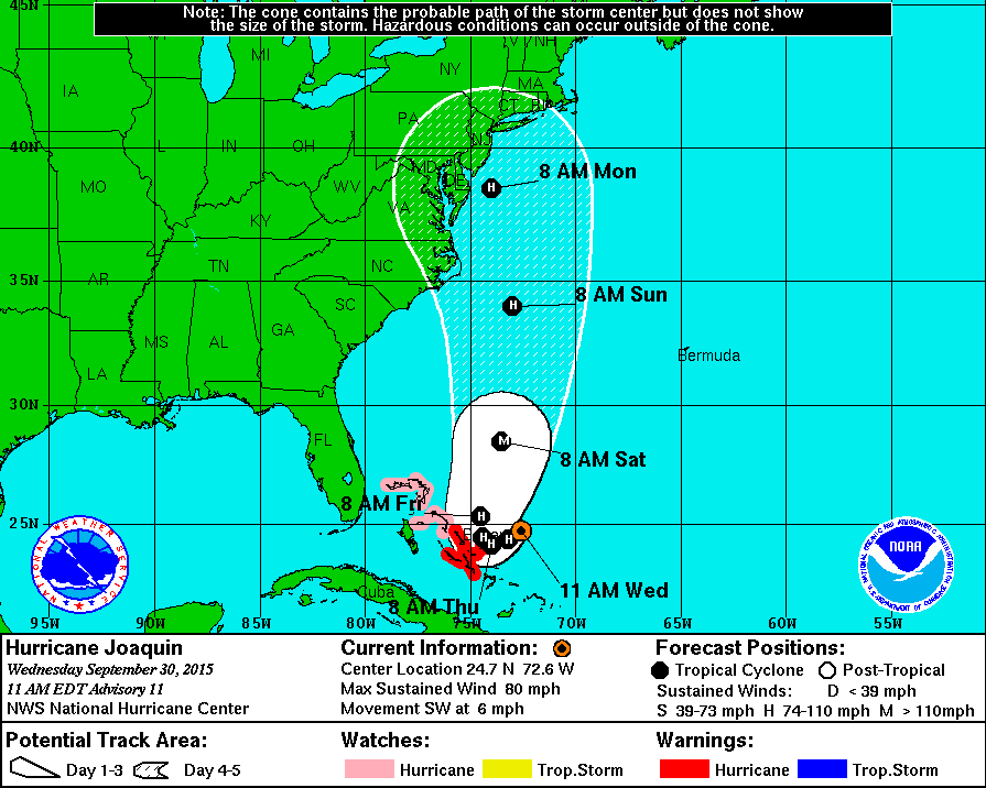
The Hurricane Center forecast track is to the right of the global GFS and Canadian Models and to the left of the European of last night. Needless to say if this is right and the track is to just east of Delaware Bay this would be a serious hurricane hit. We are still a long way away from the final outcome.
Be sure to download my weather app and subscribe to my forecasts. The app is free and the subscription is just 99 cents a month. The app is free of advertisement and there are no tracking or security issues.