
Hurricane Joaquin continues to move away from the Bahamas and an eye is forming again so we may be seeing another round of strengthening as it heads toward or just west of Bermuda where watches are now posted. the satellite loops below how the hurricane is getting kicked away to the east away from the deep trough that exists along the east coast. Joaquin will remain a major hurricane for a little while longer.
...POWERFUL HURRICANE JOAQUIN MOVING AWAY FROM THE BAHAMAS...
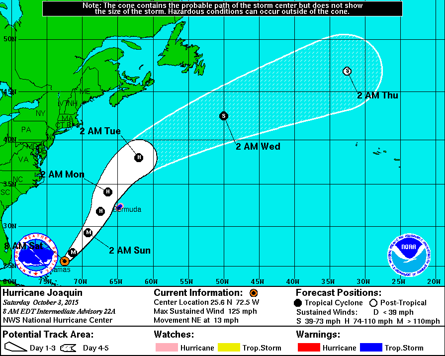
SUMMARY OF 800 AM EDT...1200 UTC...INFORMATION
----------------------------------------------
LOCATION...25.6N 72.5W
ABOUT 165 MI...270 KM NE OF SAN SALVADOR
ABOUT 660 MI...1060 KM SW OF BERMUDA
MAXIMUM SUSTAINED WINDS...125 MPH...205 KM/H
PRESENT MOVEMENT...NE OR 45 DEGREES AT 13 MPH...20 KM/H
MINIMUM CENTRAL PRESSURE...940 MB...27.76 INCHES
 WATCHES AND WARNINGS
--------------------
CHANGES WITH THIS ADVISORY:
The Government of the Bahamas has discontinued all watches and
warnings for the Bahamas and for the Turk and Caicos Islands.
SUMMARY OF WATCHES AND WARNINGS IN EFFECT:
A Tropical Storm Warning is in effect for...
* Bermuda
A Hurricane Watch is in effect for...
* Bermuda
WATCHES AND WARNINGS
--------------------
CHANGES WITH THIS ADVISORY:
The Government of the Bahamas has discontinued all watches and
warnings for the Bahamas and for the Turk and Caicos Islands.
SUMMARY OF WATCHES AND WARNINGS IN EFFECT:
A Tropical Storm Warning is in effect for...
* Bermuda
A Hurricane Watch is in effect for...
* Bermuda


Also if there is any doubt that the events along the east coast are separate issues the loop shows it clearly. The hurricane is in one world now and the trough in the east is producing noreaster conditions and is totally separate. We would be experience noreaster conditions no matter that there is a hurricane off the east coast. The other take away is that given the setup along the east coast, had this storm moved up into this tight pressure gradient after 3 days of northeast winds, the damage would have been considerable.
Be sure to download my weather app and subscribe to my forecasts. The app is free and the subscription is though the 99 cents a month. The app is free of advertisement and there are no tracking or security issues.