Hurricane Irma Winds 100 mph Strengthening Continues
Hurricane Irma Winds 100 mph Strengthening Continues

The latest satellite loop continues show Irma getting better organized as it moves on a course north of due west in the Eastern Tropical Atlantic. The system has a well defined core. There does not appear to be anything in the way of continued strengthening at the moment. The system is very symetrical with good inflow and expanding outflow so strengthening should continue.

The wide view on the satellite loops this morning show that Irma pretty much sits alone in the Tropical Atlantic. To the northwest of Irma there is an upper low and you can see it on the water vapor imagery. That upper low has been drifting slowly southwestward overnight and this morning but weather models have that upper low lifting out to the northwest later today and tonight. That is really the only thing that would prevent Irma from strengthening further is if that upper low were to drop southwestward and create a strong wind shear environment. For now we will assume the weather models are correct and that the upper low will get out of the way later today. Assuming no other unforeseen issues, Irma will become a major hurricane before it reaches the Leeward Islands.

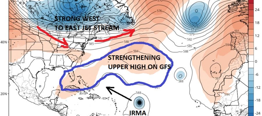
Weather models overnight continue to have tracks that vary widely. The trend that is important is that the GFS model continues to come in further west with each run. This is because of how the models handle the strengthening upper ridge in the Atlantic which is for now the primary driver.
GFS UPPER AIR JET STREAM MONDAY SEPTEMBER 4, 2017

EUROPEAN UPPER AIR JET STREAM MONDAY SEPTEMBER 4, 2017
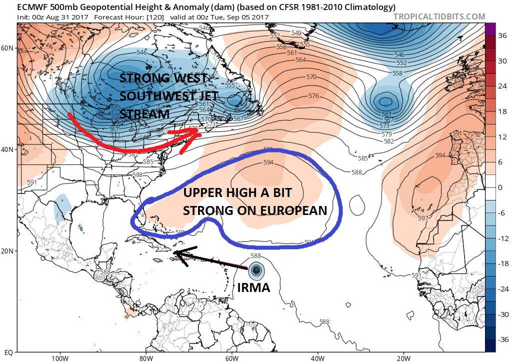
The GFS and the European at least through day 5 are remarkably similar however there are a couple of subtle differences that are very important. First is the fact that both model have the strengthening upper ridge in the Atlantic. Both have the strong west to west southwest flow of the jet stream across the Great Lakes and Northeast. Both have Irma east of the islands. However the European has the Atlantic high a bit stronger with less of a weakness to the northwest. The result is that the European takes Irma over or just north (or just south) of all the islands from the Northern Leewards to Cuba. The GFS has Irma responding to the weakness where IRMA tracks north of the islands by a fair amount of distance. This also impacts strength with the European showing a weaker category 2-3 hurricane while the GFS revs this up at least to a category 4 and possibly a 5.

All of the intensity models have Irma a hurricane and the majority take it at least to a category 3 hurricane with 2 up to a category 4. A few leave it as a category 1. This probably reflects the usual model volatility and it should be noted that intensity models are not the best tools when it comes to forecasting strength. Some are better than others and all have their flaws. The upper low to the northwest of Irma is the first consideration and the other is track that moves it over the islands from east to west.
At this point I would not rule out the European’s more southern solution with the idea of the stronger ridge. The European did handle Harvey quite well and was much more consistent run after run than the GFS model was. We will see how these trends play out later today.
…HURRICANE IRMA RAPIDLY INTENSIFYING OVER THE EASTERN ATLANTIC…
SUMMARY OF 1100 AM AST…1500 UTC…INFORMATION
———————————————–
LOCATION…16.9N 33.8W
ABOUT 650 MI…1050 KM W OF THE CABO VERDE ISLANDS
ABOUT 1845 MI…2975 KM E OF THE LEEWARD ISLANDS
MAXIMUM SUSTAINED WINDS…100 MPH…155 KM/H
PRESENT MOVEMENT…WNW OR 290 DEGREES AT 10 MPH…17 KM/H
MINIMUM CENTRAL PRESSURE…979 MB…28.91 INCHES
WATCHES AND WARNINGS
——————–
There are no coastal watches or warnings in effect.
DISCUSSION AND 48-HOUR OUTLOOK
——————————
At 1100 AM AST (1500 UTC), the center of Hurricane Irma was located
near latitude 16.9 North, longitude 33.8 West. Irma is moving toward
the west-northwest near 10 mph (17 km/h). This general motion is
forecast through early Friday, followed by a generally westward
motion on Saturday.
Maximum sustained winds have increased to near 100 mph (155 km/h)
with higher gusts. Irma is forecast to become a major hurricane by
tonight and is expected to be an extremely dangerous hurricane for
the next several days.
Hurricane-force winds extend outward up to 15 miles (30 km) from the
center and tropical-storm-force winds extend outward up to 80 miles
(130 km).
The estimated minimum central pressure is 979 mb (28.91 inches).
HAZARDS AFFECTING LAND
———————-
None
MANY THANKS TO TROPICAL TIDBITS FOR THE WONDERFUL USE OF THE MAPS
Weather App

Don’t be without Meteorologist Joe Cioffi’s weather app. It is really a meteorologist app because you get my forecasts and my analysis and not some automated computer generated forecast based on the GFS model. This is why your app forecast changes every 6 hours. It is model driven with no human input at all. It gives you an icon, a temperature and no insight whatsoever.
It is a complete weather app to suit your forecast needs. All the weather information you need is right on your phone. Android or I-phone, use it to keep track of all the latest weather information and forecasts. This weather app is also free of advertising so you don’t have to worry about security issues with your device. An accurate forecast and no worries that your device is being compromised.
Use it in conjunction with my website and my facebook and twitter and you have complete weather coverage of all the latest weather and the long range outlook. The website has been redone and upgraded. Its easy to use and everything is archived so you can see how well Joe does or doesn’t do when it comes to forecasts and outlooks.
Just click on the google play button or the apple store button on the sidebar for my app which is on My Weather Concierge. Download the app for free. Subscribe to my forecasts on an ad free environment for just 99 cents a month.
Get my forecasts in the palm of your hand for less than the cost of a cup of Joe!