Hurricane Irma Catastrophic Category 5 (not 6) 185 MPH Winds
Hurricane Irma Catastrophic Category 5 (not 6) 185 MPH Winds

Hurricane Irma with winds of 185 mph is withing 100 miles of the Northern Leeward Islands. We have seen a subtle jog north of west in its course but it may not be enough to keep the eye from moving over some the Northern Leewards like Antigua and Anguilla. It appears the eye will go over some of those Northern Islands with the Virgin Islands the next stop. On the satellite loop below to the south and east of Irma we have Tropical Storm Jose which we will deal with on a separate post as time permits

It also appears that we have a tropical depression in the Southwest Gulf of Mexico. The loop shows what appears to be a low level circulation developing just of the coast of Mexico near or south of Tampico. It would seem given the upper air conditions over the next few days that this system should be pinned down in the Southwest Gulf of Mexico but it should monitor the situation closely

HURRICANE IRMA IMPACTS ON FLORIDA
There are many critical questions for Florida. First off is the point of landfall and the path that takes it there. Weather models have a very narrow spread in these tracks but the spread is enough for different outcomes.
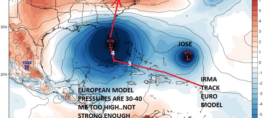
GFS MODEL HURRICANE IRMA FORECAST TRACK AND STRENGTH

For days the GFS has shown a category 5 hurricane and since the other models have been way less intense with this all along it would seem the GFS extreme pressure forecast is possible. This is especially true if Irma tracks to the west northwest and avoids contact with the Dominican Republic and Cuba. The GFS is the furthest east of all the models and has two landfalls, one in Southeast Florida and then up the coast just offshore and a second along the Georgia South Carolina coast.
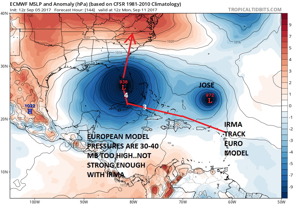
The European has a track that is a little more south and west taking the hurricane briefly over Cuba which would keep it weaker before restrengthening it and taking it up the west coast of Florida. Now there are two issues here. Irma is more than 40 millibars deeper (more intense) than the model has it. This could be the reason why the European with a weaker system is responding to a lower level westerly flow. This and the models left (west) bias leads me to believe the European is too far left. The GFS with the more intense system will show motion based more on the higher level winds in the atmosphere and this could explain why the GFS is on the east side of all the models. The Canadian in its usually silliness is not even begin considered here.
Hurricane Irma Model Tracks

All the track models are inside the 2 global models so the confidence on the Florida landfall is very high at this point. There is the possibility that the hurricane could take a north south track slicing the state in half where hurricane force winds are being experienced on both coasts. It is going to come down to some very subtle things in the upper atmosphere that will determine the final track of Hurricane Irma
…POTENTIALLY CATASTROPHIC CATEGORY 5 HURRICANE IRMA NEARING THE
NORTHERN LEEWARD ISLANDS…
…WEATHER CONDITIONS WILL DETERIORATE OVER THE NORTHERN LEEWARD
ISLANDS SOON…
SUMMARY OF 500 PM AST…2100 UTC…INFORMATION
———————————————-
LOCATION…17.1N 59.8W
ABOUT 130 MI…210 KM E OF ANTIGUA
ABOUT 135 MI…220 KM ESE OF BARBUDA
MAXIMUM SUSTAINED WINDS…185 MPH…295 KM/H
PRESENT MOVEMENT…W OR 280 DEGREES AT 15 MPH…24 KM/H
MINIMUM CENTRAL PRESSURE…926 MB…27.35 INCHES
WATCHES AND WARNINGS
——————–
CHANGES WITH THIS ADVISORY:
The government of the Dominican Republic has issued a Hurricane
Warning along the north coast of the Dominican Republic from the
border with Haiti eastward to Cabo Engano. A tropical storm
warning has been issued for the south coast of the Dominican
Republic from south of Cabo Engano westward to the southern border
with Haiti.
SUMMARY OF WATCHES AND WARNINGS IN EFFECT:
A Hurricane Warning is in effect for…
* Antigua, Barbuda, Anguilla, Montserrat, St. Kitts, and Nevis
* Saba, St. Eustatius, and Sint Maarten
* Saint Martin and Saint Barthelemy
* British Virgin Islands
* U.S. Virgin Islands
* Puerto Rico, Vieques, and Culebra
* Dominican Republic from Cabo Engano to the northern border with
Haiti
A Hurricane Watch is in effect for…
* Guadeloupe
* Haiti from the northern border with the Dominican Republic to Le
Mole St. Nicholas
* Turks and Caicos Islands
* Southeastern Bahamas
A Tropical Storm Warning is in effect for…
* Guadeloupe
* Dominica
* Dominican Republic from south of Cabo Engano westward to the
southern border with Haiti
A Tropical Storm Watch is in effect for…
* Haiti from south of Le Mole St. Nicholas to Port-Au-Prince
MANY THANKS TO TROPICAL TIDBITS FOR THE WONDERFUL USE OF THE MAPS
 GET JOE A CIGAR IF YOU LIKE

Weather App

Don’t be without Meteorologist Joe Cioffi’s weather app. It is really a meteorologist app because you get my forecasts and my analysis and not some automated computer generated forecast based on the GFS model. This is why your app forecast changes every 6 hours. It is model driven with no human input at all. It gives you an icon, a temperature and no insight whatsoever.
It is a complete weather app to suit your forecast needs. All the weather information you need is right on your phone. Android or I-phone, use it to keep track of all the latest weather information and forecasts. This weather app is also free of advertising so you don’t have to worry about security issues with your device. An accurate forecast and no worries that your device is being compromised.
Use it in conjunction with my website and my facebook and twitter and you have complete weather coverage of all the latest weather and the long range outlook. The website has been redone and upgraded. Its easy to use and everything is archived so you can see how well Joe does or doesn’t do when it comes to forecasts and outlooks.
Just click on the google play button or the apple store button on the sidebar for my app which is on My Weather Concierge. Download the app for free. Subscribe to my forecasts on an ad free environment for just 99 cents a month.
Get my forecasts in the palm of your hand for less than the cost of a cup of Joe!