Hurricane Irma Begins Westward Course
Hurricane Irma Begins Westward Course

Hurricane Irma continues to move on a slow steady course and during the day it appears that Irma is moving to the west. The hurricane is maintaining a well defined core with an eye still visible. This is going on even though Irma is over realtively cooler waters at the moment. However by Sunday Irma should be west of 45 degrees west where the water temperatures are in the mid 80s. This plus a favorable environment aloft should allow gradual strengthening to begin. Irma will become a category 4 hurricane next week as it nears the Leeward Islands.

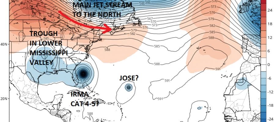
The key to the forecast over the next two days lies in how Hurricane Irma reacts to the upper low to the northwest of it. You can see it clearly on the water vapor loop. The upper low is moving westward which keeps Irma out of the hostile wind environment. It also will assist in steering Irma to the southwest which is critical to whether Irma could eventually move over the Leeward Islands or pass to the north of the Leewards. It could also impact how far west Irma ultimately gets later next week as it nears the Southeast coast of the United States.

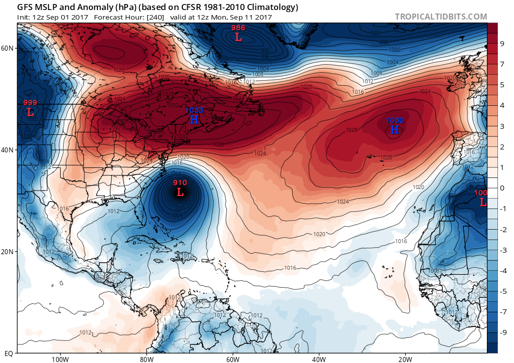
Once we resolve the question of the Leeward Islands, the next question is where to from there. Does Irma make it to about 70 degrees west before turning. This is the GFS idea this afternoon
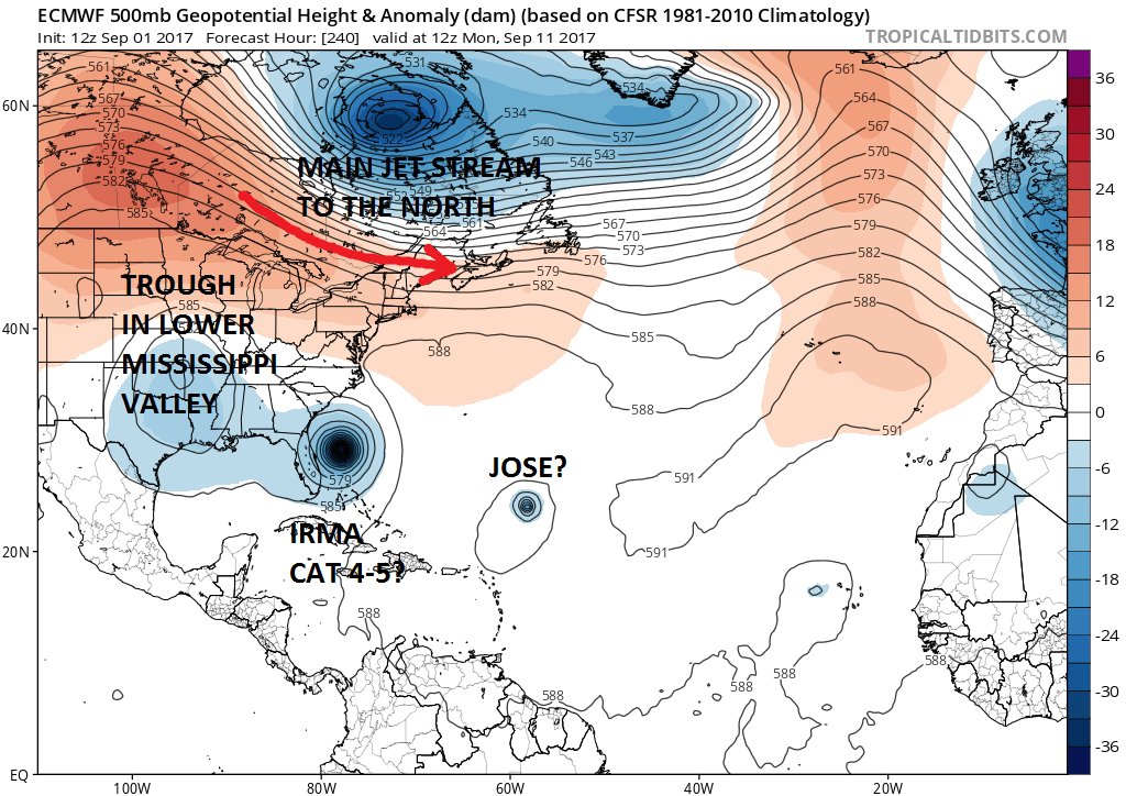
The European model this afternoon is not that different from the GFS as it has a major hurricane off the Florida coast for the same time frame at day 10.
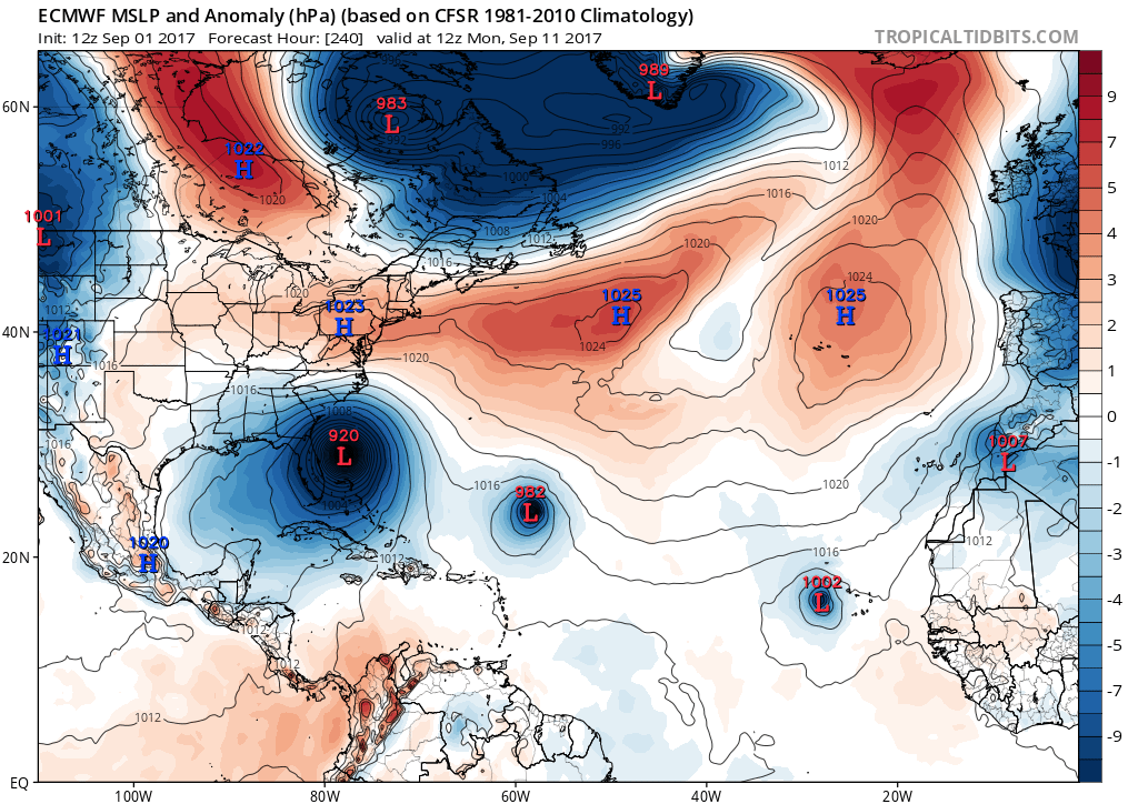
The forecast range here is still too far out to be considered reliable so the large uncertainty remains. However the models seem to agree that Hurricane Irma will be somewhere off the Southeast coast of the US next weekend. Even the Canadian model is in the same general area.
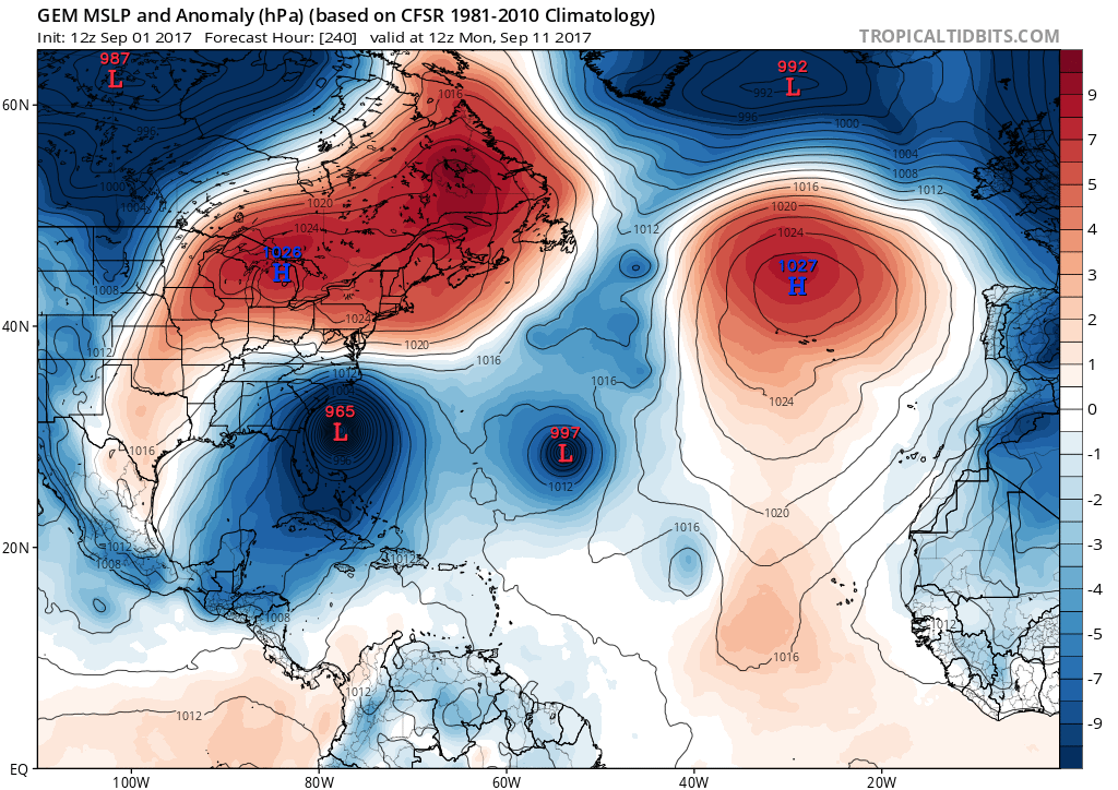
It is a bit concerning that all three models have a rather similar look here at day 10 when most of the time the models are totally different that far out. This is a rather new development and it we need to see if this is a one run hiccup or the beginning of a trend. The upper air profile on all three models is also similar though the European has the stronger Canadian jet stream further south.
Here are the list of questions that we are facing regarding the fate of Hurricane Irma
- Will the southwest motion materialize and if it does for how long? This will determine whether Hurricane Irma will be far enough south to be a threat to the Leeward Islands.
- From the Leewards, the motion will continue to the west northwest toward the Bahamas. How far west does it get before Hurricane Irma begins to feel the effects of troughing to the west and north. Does it make it to 70 West, 75, or even to 80?
- How much northward component of motion will it have once it is north of 65 degrees west.
- How strong will Irma get? Water temperatures over 30C and a favorable environment should bring Irma at least to a category 4 hurricane.
The uncertainty continues but the fact that models seem to be coming in a little bit is a good sign. Let’s see if this continues over the weekend.
MANY THANKS TO TROPICAL TIDBITS FOR THE WONDERFUL USE OF THE MAPS
 GET JOE A CIGAR IF YOU LIKE

Weather App

Don’t be without Meteorologist Joe Cioffi’s weather app. It is really a meteorologist app because you get my forecasts and my analysis and not some automated computer generated forecast based on the GFS model. This is why your app forecast changes every 6 hours. It is model driven with no human input at all. It gives you an icon, a temperature and no insight whatsoever.
It is a complete weather app to suit your forecast needs. All the weather information you need is right on your phone. Android or I-phone, use it to keep track of all the latest weather information and forecasts. This weather app is also free of advertising so you don’t have to worry about security issues with your device. An accurate forecast and no worries that your device is being compromised.
Use it in conjunction with my website and my facebook and twitter and you have complete weather coverage of all the latest weather and the long range outlook. The website has been redone and upgraded. Its easy to use and everything is archived so you can see how well Joe does or doesn’t do when it comes to forecasts and outlooks.
Just click on the google play button or the apple store button on the sidebar for my app which is on My Weather Concierge. Download the app for free. Subscribe to my forecasts on an ad free environment for just 99 cents a month.
Get my forecasts in the palm of your hand for less than the cost of a cup of Joe!