Hurricane Ian 155 mph Winds Near Category 5
Rain Possibilites Up the Coast Over the Weekend
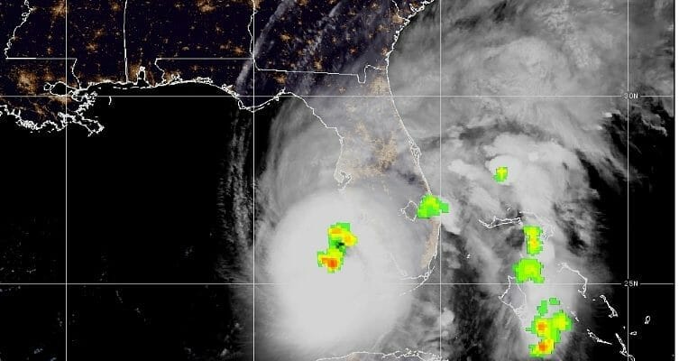
SUMMARY OF 800 AM EDT…1200 UTC…INFORMATION
LOCATION…26.0N 82.7W
ABOUT 55 MI…90 KM W OF NAPLES FLORIDA
ABOUT 60 MI…100 KM SW OF PUNTA GORDA FLORIDA
MAXIMUM SUSTAINED WINDS…155 MPH…250 KM/H
PRESENT MOVEMENT…NNE OR 15 DEGREES AT 10 MPH…17 KM/H
MINIMUM CENTRAL PRESSURE…937 MB…27.67 INCHES
SATELLITE

WEATHER RADAR

Hurricane Ian continued to strengthen rapidly overnight and is now heading toward a landfall this afternoon as a category 4 or possibly as a category 5. The eye as of 8am was well defined on the satellite and radar loops and landfall looks to be on the Florida west coast somewhere near Port Charolotte/Punta Gorda. Fluctionations in strength and track could occur until landfall later this afternoon.

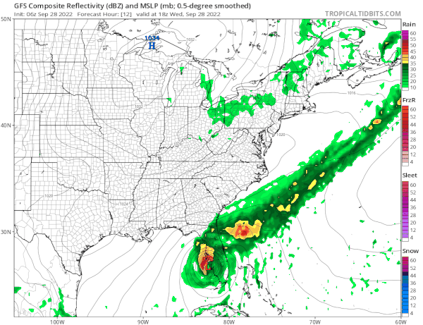
Late yesterday Ian began a move more to the north northeast and that now changes the outlook longer term for the Mid Atlantic and perhaps southern areas of the Northeast for the weekend. First things first is that Ian will cross Florida and produce 15 or more inches of rain along and north of the track of the center. Then it will emerge into the Atlantic and perhaps strengthen again with a landfall along the Georgia Coast or South Carolina some time Friday. The trip across Florida will weaken the storm somewhat but it should be a category 1 hurricane when it gets to the Atlantic side. Time will likely limit the amount of restrengthening before the second landfall.
Meanwhile high pressure covers the Northeast and Mid Atlantic states with lots of dry air and that dry air extends into the Southeast US. There are no weather issues to worry about through Friday. We are going to have a good deal of sunshine today with just a few patchy clouds. Eastern Pennsylvania to Southern New England highs will be in the upper 60s and lower 70s.

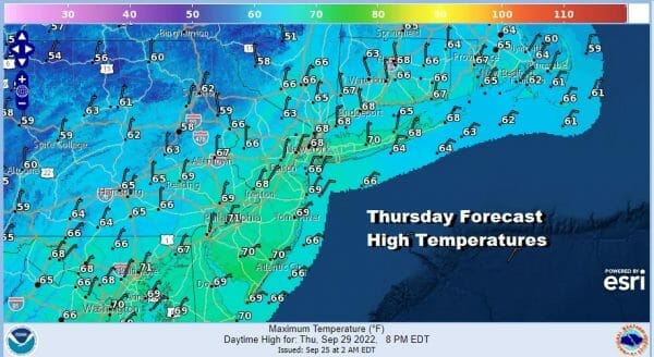
Thursday and Friday should be two lovely Autumn days with sunshine and highs both days in the 60s. Depending on what happens with Ian some high clouds could move in from south to north late Friday and increase further Friday night. As the GFS model above shows, the latest runs bring rain up the coast and to about Southern New England, the Lower Hudson Valley to Northern New Jersey and Northeast Pa on Saturday but the northern edge will be impacted by the dry air to the north. Southern New Jersey and Southern Pennsylvania southward stand a better chance of a more significant rainfall of up to a couple of inches. This is one of those situtations where sometimes the model suppresses too much and the rain area gets a lot further north than advertised. One thing that leans against the idea that we could see IDA-LIKE rains is the fact that the core of the storm has a tougher time staying together and it gets left behind in the mountains. That is one variable that we will be looking at in case that changes. Still some areas could see significant rains and we will monitor how the model handles the remnant core. Bottom line is that for now we will call for a cloudy weekend with the chance for some rain especially if you are south of a line from NYC to Philadelphia and wait to see what developments occur later today with both Ian and the weather models.
BE SURE TO DOWNLOAD THE FREE METEOROLOGIST JOE CIOFFI WEATHER APP &
ANGRY BEN’S FREE WEATHER APP “THE ANGRY WEATHERMAN!
MANY THANKS TO TROPICAL TIDBITS & F5 WEATHER FOR THE USE OF MAPS
Please note that with regards to any severe weather, tropical storms, or hurricanes, should a storm be threatening, please consult your local National Weather Service office or your local government officials about what action you should be taking to protect life and property.


