HURRICANE HARVEY INTENSIFYING RAPIDLY
HURRICANE HARVEY INTENSIFYING RAPIDLY
Latest satellite and Air Force aircraft reports indicate that Harvey is intensifying rapidly. The pressure has dropped nearly 30 millibars since last night and it is well on its way to becoming a major hurricane. The loop shows that Harvey is continuing to organize as a steady track to the north northwest continues.
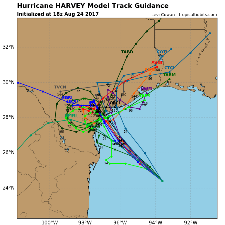
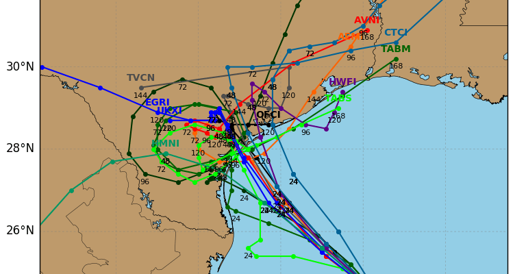
Which ever track you choose from the hurricane model plots above, they all will result in extensive damage and flooding across much of South and Southeast Texas. Weather models all slow this down to a crawl or even stall it out for 2 or 3 days. As the center slows near the coast many areas from Corpus Christi nortward to Port Lavaca could see continuous hurricane conditions for 24 to 36 hours.

..HARVEY RAPIDLY INTENSIFYING…
…PREPARATIONS ALONG THE MIDDLE TEXAS COAST SHOULD BE RUSHED TO
COMPLETION TODAY…
SUMMARY OF 100 PM CDT…1800 UTC…INFORMATION
———————————————-
LOCATION…24.4N 93.6W
ABOUT 335 MI…540 KM SE OF CORPUS CHRISTI TEXAS
ABOUT 325 MI…525 KM SSE OF PORT OCONNOR TEXAS
MAXIMUM SUSTAINED WINDS…85 MPH…140 KM/H
PRESENT MOVEMENT…NNW OR 335 DEGREES AT 10 MPH…17 KM/H
MINIMUM CENTRAL PRESSURE…979 MB…28.91 INCHES
WATCHES AND WARNINGS
——————–
CHANGES WITH THIS ADVISORY:
The Storm Surge Warning has been extended northeast of San Luis
Pass to High Island Texas.
SUMMARY OF WATCHES AND WARNINGS IN EFFECT:
A Storm Surge Warning is in effect for…
* Port Mansfield to High Island Texas
A Storm Surge Watch is in effect for…
* South of Port Mansfield Texas to the Mouth of the Rio Grande
A Hurricane Warning is in effect for…
* Port Mansfield to Matagorda Texas
A Tropical Storm Warning is in effect for…
* North of Matagorda to High Island Texas
* South of Port Mansfield Texas to the Mouth of the Rio Grande
A Hurricane Watch is in effect for…
* South of Port Mansfield Texas to the Mouth of the Rio Grande
A Tropical Storm Watch is in effect for…
* South of the Mouth of the Rio Grande to Boca de Catan Mexico
A Storm Surge Warning means there is a danger of life-threatening
inundation, from rising water moving inland from the coastline,
during the next 36 hours in the indicated locations. For a
depiction of areas at risk, please see the National Weather
Service Storm Surge Watch/Warning Graphic, available at
hurricanes.gov. This is a life-threatening situation. Persons
located within these areas should take all necessary actions to
protect life and property from rising water and the potential for
other dangerous conditions. Promptly follow evacuation and other
instructions from local officials.
A Hurricane Warning means that hurricane conditions are expected
somewhere within the warning area. A warning is typically issued
36 hours before the anticipated first occurrence of tropical-storm-
force winds, conditions that make outside preparations difficult or
dangerous. Preparations to protect life and property should be
rushed to completion.
A Tropical Storm Warning means that tropical storm conditions are
expected somewhere within the warning area within 36 hours.
A Storm Surge Watch means there is a possibility of life-
threatening inundation, from rising water moving inland from the
coastline, in the indicated locations during the next 48 hours.
A Hurricane Watch means that hurricane conditions are possible
within the watch area.
A Tropical Storm Watch means that tropical storm conditions are
possible within the watch area.
In addition, interests in southwestern Louisiana should continue to
monitor the progress of this system.
For storm information specific to your area in the United States,
including possible inland watches and warnings, please monitor
products issued by your local National Weather Service forecast
office. For storm information specific to your area outside the
United States, please monitor products issued by your national
meteorological service.
DISCUSSION AND 48-HOUR OUTLOOK
——————————
At 100 PM CDT (1800 UTC), the eye of Hurricane Harvey was located
by reconnaissance aircraft near latitude 24.4 North, longitude 93.6
West. Harvey is moving toward the north-northwest near 10 mph (17
km/h). A turn toward the northwest is expected later today, and
Harvey’s forward speed is forecast to slow down during the next
couple of days. On the forecast track, Harvey will approach the
middle Texas coast on Friday and make landfall Friday night or early
Saturday, and then stall near the middle Texas coast through the
weekend.
Data from Air Force Reserve and NOAA Hurricane Hunter aircraft
indicate that maximum sustained winds have increased to near 85 mph
(140 km/h) with higher gusts. Additional rapid strengthening is
forecast, and Harvey is expected to become a major hurricane by
Friday before it reaches the middle Texas coast.
Hurricane-force winds extend outward up to 25 miles (35 km) from the
center, and tropical-storm-force winds extend outward up to 90 miles
(150 km).
Data from the NOAA Hurricane Hunter plane indicate that the minimum
central pressure is 979 mb (28.91 inches).
HAZARDS AFFECTING LAND
———————-
RAINFALL: Harvey is expected to produce total rain accumulations of
12 to 20 inches and isolated maximum amounts of 30 inches over the
middle and upper Texas coast through next Wednesday. During the same
time period Harvey is expected to produce total rain accumulations
of 5 to 12 inches in far south Texas and the Texas Hill Country to
central Louisiana, with accumulations of less than 5 inches
extending into other parts of Texas and the lower Mississippi
Valley. Rainfall from Harvey may cause life-threatening flooding.
STORM SURGE: The combination of a dangerous storm surge and the
tide will cause normally dry areas near the coast to be flooded by
rising waters moving inland from the shoreline. The water is
expected to reach the following heights above ground if the peak
surge occurs at the time of high tide…
N Entrance Padre Island Natl Seashore to Sargent…6 to 12 ft
Sargent to Jamaica Beach…5 to 8 ft
Port Mansfield to N Entrance Padre Island Natl Seashore…5 to 7 ft
Jamaica Beach to High Island…2 to 4 ft
Mouth of the Rio Grande to Port Mansfield…2 to 4 ft
High Island to Morgan City…1 to 3 ft
The deepest water will occur along the immediate coast near and to
the northeast of the landfall location, where the surge will be
accompanied by large and destructive waves. Surge-related flooding
depends on the relative timing of the surge and the tidal cycle, and
can vary greatly over short distances. For information specific to
your area, please see products issued by your local National Weather
Service forecast office.
WIND: Hurricane conditions are likely within the hurricane warning
area late Friday or Friday night, with tropical storm conditions
expected to first reach the coast in the hurricane warning area
Friday.
SURF: Swells generated by Harvey are likely to affect the Texas,
Louisiana, and northeast Mexico coasts by Friday. These swells are
likely to cause life-threatening surf and rip current conditions.
Please consult products from your local weather office.

Conditions remain favorable for steady to rapid strengthening. Hurricane Harvey will soon move over 90 degree water which will give it even more latent heat to work with.

MANY THANKS TO TROPICAL TIDBITS FOR THE WONDERFUL USE OF THE MAPS
Weather App

Don’t be without Meteorologist Joe Cioffi’s weather app. It is really a meteorologist app because you get my forecasts and my analysis and not some automated computer generated forecast based on the GFS model. This is why your app forecast changes every 6 hours. It is model driven with no human input at all. It gives you an icon, a temperature and no insight whatsoever.
It is a complete weather app to suit your forecast needs. All the weather information you need is right on your phone. Android or I-phone, use it to keep track of all the latest weather information and forecasts. This weather app is also free of advertising so you don’t have to worry about security issues with your device. An accurate forecast and no worries that your device is being compromised.
Use it in conjunction with my website and my facebook and twitter and you have complete weather coverage of all the latest weather and the long range outlook. The website has been redone and upgraded. Its easy to use and everything is archived so you can see how well Joe does or doesn’t do when it comes to forecasts and outlooks.
Just click on the google play button or the apple store button on the sidebar for my app which is on My Weather Concierge. Download the app for free. Subscribe to my forecasts on an ad free environment for just 99 cents a month.
Get my forecasts in the palm of your hand for less than the cost of a cup of Joe!