Hurricane Beryl 75 MPH Winds Moving Westward
Hurricane Beryl 75 MPH Winds Moving Westward

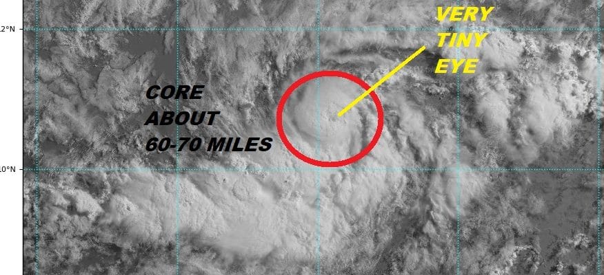
In 24 hours we have gone from a vigorous tropical wave to a hurricane. Hurricane Beryl is a very tiny hurricane with top winds of 75 mph. The core of the hurricane is barely 60 to 75 miles across. Gales only extend out about 30 miles or so from the center. It is actually very hard to pick it out in the satellite loop on the wide view as it is in the lower right. The eye of the hurricane is the size of a pin prick. Beryl is remarkable in that there is so much dry air around it yet it has managed to get wrapped up inside an area of moist air and very light winds aloft. Beryl could actually strengthen further before it runs into an area of increasing upper air winds which should cause it to weaken rather quickly over the weekend.
Hurricane Beryl is about 1100 miles east of the Lesser Antillies and it should weaken into an open wave by the time it gets there but it may be a close call for the Leewards. Given the tiny size of this system it could pass within 30 miles or so of a given area and you wouldn’t even know it was there!
WIDE ATLANTIC TROPICAL SATELLITE

...TINY BERYL BECOMES THE FIRST HURRICANE OF THE 2018 ATLANTIC
HURRICANE SEASON...


SUMMARY OF 500 AM AST...0900 UTC...INFORMATION
----------------------------------------------
LOCATION...10.6N 45.1W
ABOUT 1140 MI...1830 KM ESE OF THE LESSER ANTILLES
MAXIMUM SUSTAINED WINDS...75 MPH...120 KM/H
PRESENT MOVEMENT...W OR 275 DEGREES AT 14 MPH...22 KM/H
MINIMUM CENTRAL PRESSURE...995 MB...29.39 INCHES


WATCHES AND WARNINGS
--------------------
There are no coastal watches or warnings in effect.

Interests in the Lesser Antilles should monitor the progress of
Beryl.


DISCUSSION AND OUTLOOK
----------------------
At 500 AM AST (0900 UTC), the center of Hurricane Beryl was located
near latitude 10.6 North, longitude 45.1 West. Beryl is moving
toward the west near 14 mph (22 km/h). A faster west-northwestward
motion is expected through the weekend.  On the forecast track, the
center of Beryl will remain east of the Lesser Antilles through
early Sunday.

Satellite data indicate the maximum sustained winds have
increased to near 75 mph (120 km/h) with higher gusts.  Some
additional strengthening is forecast today. Beryl is forecast to
quickly weaken by late Saturday and become a tropical storm or
degenerate into a strong open trough near the Lesser Antilles late
Sunday or Monday.

Beryl is a very compact hurricane. Hurricane-force winds extend
outward up to 10 miles (20 km) from the center and
tropical-storm-force winds extend outward up to 35 miles
(55 km).

The estimated minimum central pressure is 995 mb (29.39 inches).
Meanwhile disturbed weather off the Southeast coast of the United States has become better organized as thunderstorms have increased during the night. We have more details on this system as the National Hurricane Center now sees this at an 80% chance of developing into a tropical depression over the next few days.
FiOS1 News Weather Forecast For Long Island
FiOS1 News Weather Forecast For New Jersey
FiOS1 News Weather Forecast For Hudson Valley