Humberto Rip Current Risk Hurricane Jerry Nearing Leeward Islands
Hurricane Humberto made its closest pass to Bermuda last night with the center passing about 100 miles to the northwest but the large storm produced hurricane force sustained winds over Bermuda with frequent gusts over 100 mph with one gust measured at 116 mph! Now that the hurricane has moved away it is transitioning into a powerful extra tropical cyclone the only remaining issues are high waves along our shoreline tonight into early Saturday and rip current risk for swimmers at the Long Island and New Jersey ocean shores so if you are beach bound this weekend please bear this in mind if you decide to go swimming.
SATELLITE

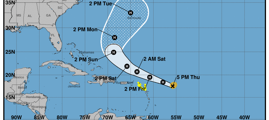
Meanwhile the next hurricane on the list is Hurricane Jerry which is now less than 400 miles east of the Leeward Islands and moving west northwestward. Max winds are now 90 mph and Jerry could strengthen a bit more tonight into Friday before it runs into a more hostile wind environment in the upper atmosphere.
REGIONAL RADAR

On its present heading it is quite likely that Hurricane Jerry will pass well north of the Northern Leeward Islands on Friday. Tropical Storm Watches are posted for the Northern Leeward Islands for Friday. Jerry will also pass well north of the Virgin Islands and Puerto Rico with minimal to no impact there other than to rough up the ocean a bit.

Upper air winds along the east coast are going to turn Jerry to the north over the weekend well to the US East Coast and more importantly the Bahamas which are still recovering from Dorian. There is a weakness off the East Coast created by Humberto that Jerry will follow. This puts Bermuda in line for another hurricane if Jerry can survive the strong upper air winds it will run into Friday night into Saturday.
MANY THANKS TO TROPICAL TIDBITS FOR THE USE OF MAPS
Please note that with regards to any tropical storms or hurricanes, should a storm be threatening, please consult your local National Weather Service office or your local government officials about what action you should be taking to protect life and property.