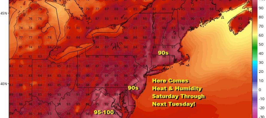
Hot Weather Arrives Saturday Through Tuesday Highs 90s
We are looking at 4 hot days in a row of 90 plus temperatures starting Saturday and lasting through Tuesday of next week. In the meantime we had another nice day though some clouds are coming in from the west as severe weather threatens Western NY and parts of Western Pennsylvania this evening. Over Eastern Pennsylvania to Southern New England we enjoyed a fair amount of sunshine and wind off the ocean all day which kept temperatures in the upper 70s to mid 80s for highs.
SATELLITE

REGIONAL RADAR

Regional radar is picking up on some showers and thunderstorms in Western NY and we also see a cluster of storms moving into Central Pennsylvania. Other showers are in North Central NY. That area is moving northeastward. Some pop up showers are showing up on the local radars but after sunset much of the activity you see will die off. Otherwise it is a warm night ahead with most lows in the mid 60s to lower 70s.
LOCAL RADAR NEW YORK CITY

LOCAL RADAR PHILADELPHIA


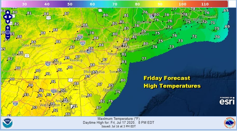
Friday will bring us a weak weather front to the coast which will be falling apart as it moves east. The air behind the front is actually warmer than the air ahead of it. The Nam model and others show a weakening area of showers and thunderstorms so we will include the chance for a few running around on Friday but I’m not expecting widespread activity. Highs will be in the 80s.

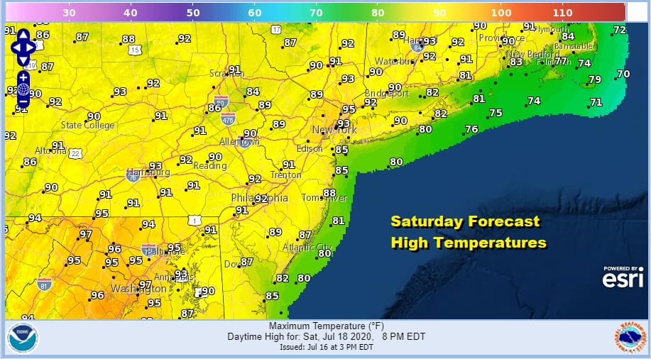
Once this system passes and dies off we will transition over to a hot air mass. Saturday will be a sunny hot day but the humidity actually will take a small drop so while it will be hot it will only be moderately humid with dew points in the low 60s and even some upper 50s are possible. No thunderstorms are forecast this weekend. Highs should reach 90 or better away from the ocean and low to mid 90s are possible Southern Pennsylvania south and west. North and east of NYC it will be in the upper 80s and lower 90s.
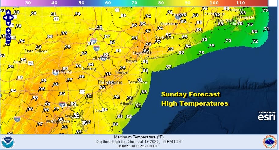
Sunday begins the steam bath with excessive heat forecast for most of the area. Highs will reach the middle and upper 90s and of course the humidity will be higher and the heat index will be well over 100 in many areas. Needless to say it is a beach or pool day for sure.
Monday will be another very hot and humid day with highs again reaching the middle to a few upper 90s. Humidity will be high again. There is the chance for a scattered shower or thunderstorm later Monday afternoon and evening but for most, you won’t see any.

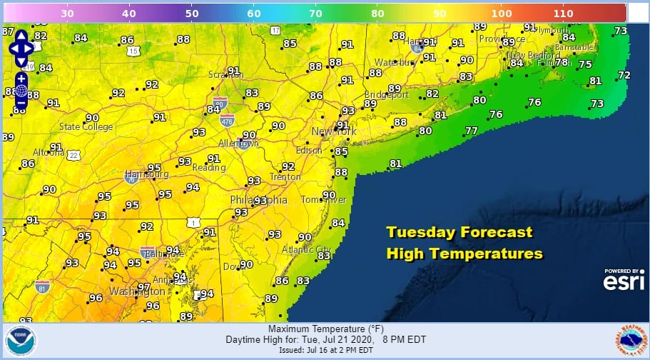
Tuesday will be the 4th day in a row of 90 degrees plus with high humidity. However there will be a cold front approaching and this possibly opens the door to a better chance for showers and thunderstorms late in the day.
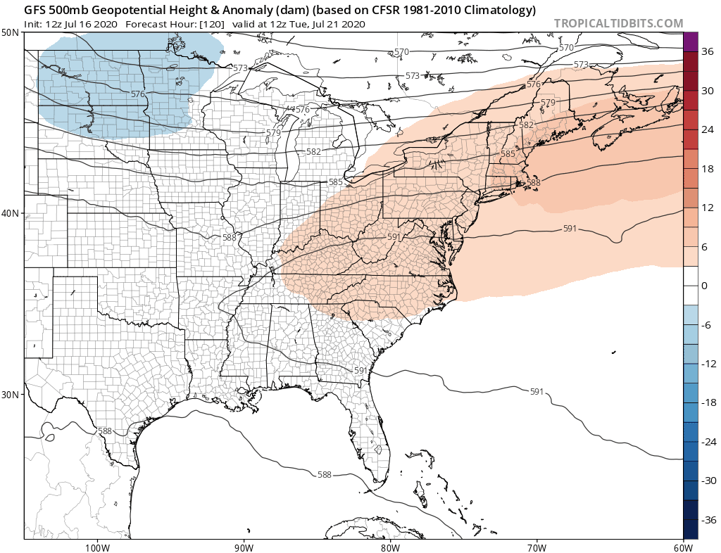
All of this has to do with a strong east west upper high that stretches from the Southwest US eastward across the Subtropical Atlantic. To the north near the Canadian border lies the jet stream with opportunities for relief. Some should come Wednesday as that upper jet drops southward just enough to suppress the upper high and the heat.
More meaningful relief could arrive on Thursday as a stronger short wave moves into the Eastern US. Ahead of this could be some meaningful showers and thunderstorms possible on Wednesday and then it looks like we could get a break in the heat and humidity late next week.
BE SURE TO DOWNLOAD THE FREE METEOROLOGIST JOE CIOFFI WEATHER APP &
ANGRY BEN’S FREE WEATHER APP “THE ANGRY WEATHERMAN!
MANY THANKS TO TROPICAL TIDBITS FOR THE USE OF MAPS
Please note that with regards to any severe weather, tropical storms, or hurricanes, should a storm be threatening, please consult your local National Weather Service office or your local government officials about what action you should be taking to protect life and property.


