
The rip currents at the beaches have been an issue for the last number of days on the south shore of Long Island. There were numerous rescues and several drowings have occured. PLEASE PLEASE PLEASE EXERCISE EXTREME CAUTION
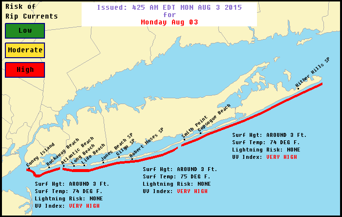
…HIGH RIP CURRENT RISK REMAINS IN EFFECT FROM 2 PM EDT THIS
AFTERNOON THROUGH THIS EVENING…
* LOCATIONS…OCEAN BEACHES OF NEW YORK CITY AND LONG ISLAND.
* RIP CURRENT RISK…BECOMING HIGH.
* SURF HEIGHT…2 TO 3 FT…BUILDING TO 3 TO 4 FT IN THE
AFTERNOON.
* LIGHTNING RISK…NONE.
* TIMING…LATE MONDAY AFTERNOON AND EVENING.
PRECAUTIONARY/PREPAREDNESS ACTIONS…
TALK TO LIFEGUARDS AND BEACH OFFICIALS TO LEARN ABOUT ANY SURF
HAZARDS AND HEED THEIR ADVICE. PAY ATTENTION TO FLAGS AND POSTED
SIGNS AND SWIM IN LIFE GUARDED AREAS.
RIP CURRENTS ARE POWERFUL CHANNELS OF WATER FLOWING QUICKLY AWAY
FROM SHORE…WHICH OCCUR MOST OFTEN AT LOW SPOTS OR BREAKS IN THE
SANDBAR AND IN THE VICINITY OF STRUCTURES SUCH AS GROINS…
JETTIES AND PIERS.
IF YOU BECOME CAUGHT IN A RIP CURRENT…YELL FOR HELP. REMAIN
CALM…DO NOT EXHAUST YOURSELF AND STAY AFLOAT WHILE WAITING FOR
HELP. IF YOU HAVE TO SWIM OUT OF A RIP CURRENT…SWIM PARALLEL TO
SHORE. ONCE YOU ARE AWAY FROM THE FORCE OF THE RIP CURRENT…
BEGIN TO SWIM BACK TOWARD THE BEACH. DO NOT ATTEMPT TO SWIM
DIRECTLY AGAINST A RIP CURRENT AS YOU WILL TIRE QUICKLY.
COASTAL WATERS SOUTH OF LONG ISLAND
SMALL CRAFT ADVISORY
SW winds 5 to 10 kt…becoming S 15 to 20 kt with gusts up to 25 kt. Seas 2 to 4 ft.
TonightS winds 20 to 25 kt…diminishing to 15 to 20 kt after midnight. Seas 3 to 5 ft. Scattered showers and tstms after midnight.
TueSW winds 10 to 15 kt. Seas 3 to 5 ft. Scattered showers and tstms in the afternoon.
Tue NightW winds 10 to 15 kt. Seas 3 to 5 ft.
WedW winds around 10 kt. Seas 2 to 4 ft.
COASTAL WATERS EAST OF NEW JERSEY
SMALL CRAFT ADVISORY
TodayS winds 10 to 15 kt with gusts up to 20 kt… Increasing to 15 to 20 kt with gusts up to 25 kt late. Seas 3 to 4 ft. Mainly in SE swell with a dominant period of 10 seconds.
TonightSW winds 15 to 20 kt with gusts up to 25 kt. Seas 4 to 6 ft. Mainly in SE swell with a dominant period of 11 seconds. scattered showers and tstms after midnight.
TueSW winds 10 to 15 kt with gusts up to 20 kt. Seas 4 to 6 ft. Mainly in SE swell with a dominant period of 11 seconds. scattered showers and tstms in the afternoon with vsby 1 to 3 nm.
Tue NightW winds 10 to 15 kt. Seas 3 to 4 ft. Mainly in S swell with a dominant period of 9 seconds.
WedW winds around 10 kt. Seas 3 to 4 ft.