Heavy Rains Flash Flooding Risk Grows From Ida Midweek

Weather in 5/Joe & Joe Weather Show Latest Podcast
Heavy Rains Flash Flooding Risk Grows From Ida Midweek
Major Hurricane Ida is inland in Southeast Louisiana and it came in as a high end category 4 hurricane. While Ida continues to ravage Southeast Louisiana, we here in the Northeast and Northern Middle Atlantic states spent the day under mostly cloudy skies. A stalled front to the south will start moving northward as a warm front and that will start a series of changes that will set us up for Ida’s remnant rains here Wednesday.
SATELLITE

In the meantime the radars nearby are quiet however the regional radar is picking up on showers and thunderstorms in Western NY and western Pennsylvania where the warm and humid air has already arrived. Those showers to the west should fall apart before they make here. Temperatures overnight will be in the upper 60s and lower 70s
WEATHER RADAR


Monday it will turn very warm and humid as the onshore flow gets cut off and replaced by a southwest flow ahead of a cold front. Most highs will be in the mid to upper 80s. We will see some sunshine and there will be a few scattered thunderstorms Monday evening as a cold front moves through and stalls right along the coast. Where it stalls will define the pathway for the remnant low of Ida to move along.
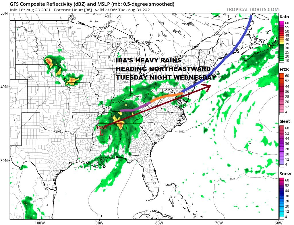
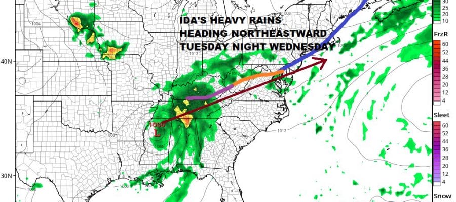
As Ida gradually weakens as a tropical storm it will begin to take on the characteristics of a non tropical storm system. The heavy rains will shift to the northwest side and ride northeastward along that stationary boundary that sits over us. This low has the potential of producing a solid 2 to 4 inch rainfall Wednesday with locally higher amounts in some areas. Obviously with all the rain from last week, the ground is saturated and the threat for flash flooding will be low. I would expect flash flood watches to go up sometime Monday for the period of late Tuesday night through early Thursday morning. In the meantime Tuesday we will see increasing clouds with highs in general will reach into the lower 80s. Humidity will be high. The air will be tropical. Then it is on to Wednesday which is the day Ida brings its rain to the Northeast and Northern Mid Atlantic.
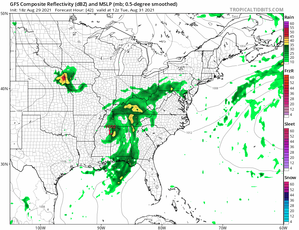
When you look at this system on the models, it looks just like a storm in the late fall or winter in terms of its structure. Low pressure heads up the Appalachians and the attempts to reform near the coast. Often times the models tend to underestimate the extent of the tropical moisture in dying hurricanes which is why the Weather Prediction Center is very bullish with rain potential
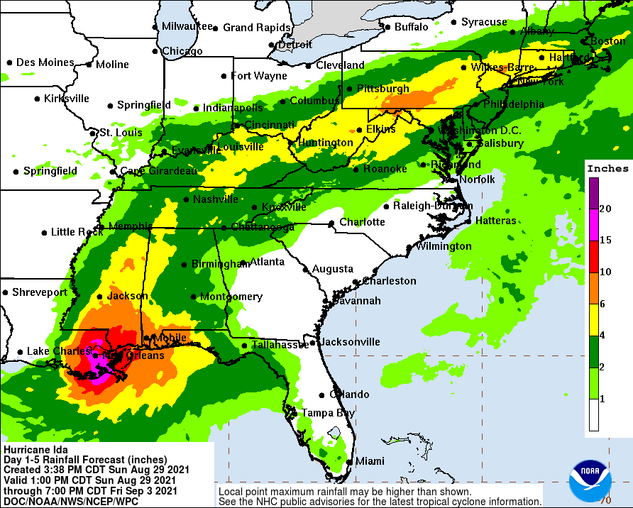
The flat-ish nature of the upper air pattern suggests that this could wind up setting up further south and we have seen that be the case over the last 2 days as the axis of the heavy rains have moved down to the coast and away from well inland Upstate NY. We are going to give it another day or so to see how this settles out but it is fair to say that the potential for a heavy soaking rain for areas from Eastern Pennsylvania and Southern New England is there for Wednesday into early Thursday. One piece of good news is that since the low is going to behave more like a non tropical system, it will pull down very nice cool clean air from Canada behind it which is just in time for at least the start of the Labor Day holiday weekend.
BE SURE TO DOWNLOAD THE FREE METEOROLOGIST JOE CIOFFI WEATHER APP &
ANGRY BEN’S FREE WEATHER APP “THE ANGRY WEATHERMAN!

MANY THANKS TO TROPICAL TIDBITS & F5 WEATHER FOR THE USE OF MAPS
Please note that with regards to any severe weather, tropical storms, or hurricanes, should a storm be threatening, please consult your local National Weather Service office or your local government officials about what action you should be taking to protect life and property.


