
Heatwave Begins Today For Some
Heatwave Begins Today For Some
Looking at the temperatures this afternoon we see some stations have already hit 90 degrees as of 3pm and there are some areas that might pop up another degree or so in the next hour. A sea breeze has developed over Long Island as winds there have turned southwest and keeping temperatures in the 80s and on the East End near 80. Excessive Heat Watch is up for most of New Jersey
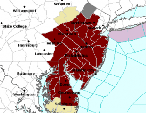
Heatwave Begins Today For Some 3pm Temperatures
CITY           SKY/WX    TMP DP  RH WIND       PRES   REMARKS
CENTRAL PARK   SUNNY     86  61  42 S3        30.12S
LAGUARDIA APRT MOSUNNY   88  63  43 S18G26    30.09S
KENNEDY INTL   MOSUNNY   83  67  58 S18       30.13S
NEWARK/LIBERTY MOSUNNY   90  56  31 SW9       30.09S
BRNX BOT. GARD   N/A     88  57  35 NW1       30.10S
TETERBORO      MOSUNNY   90  54  29 SW8G17    30.07F
$$

NYZ177-179-078>081-212000-
LONG ISLAND NEW YORK

CITY           SKY/WX    TMP DP  RH WIND       PRES   REMARKS
FARMINGDALE    SUNNY     84  67  56 S17       30.11F
ISLIP          MOSUNNY   83  64  52 SW16      30.10F
SHIRLEY        SUNNY     83  68  60 S14       30.12S
RIVERHEAD      NOT AVBL
WESTHAMPTON    SUNNY     81  67  62 SW12      30.13F
SOUTHAMPTON      N/A     77  72  83 SW12      30.07
BRIDGEHAMPTON    N/A     82  68  61 N2        30.11
EAST HAMPTON   FAIR      80  68  66 SW10      30.10F
MONTAUK POINT    N/A     79  69  71 SW8G18    30.11F
$$

NYZ052-065-067-212000-
HUDSON VALLEY

CITY           SKY/WX    TMP DP  RH WIND       PRES   REMARKS
WHITE PLAINS   MOSUNNY   87  54  32 W9        30.09F
NEWBURGH       MOSUNNY   88  59  37 W14       30.10F
MONTGOMERY     SUNNY     90  56  31 NW6       30.07F
POUGHKEEPSIE   SUNNY     90  58  33 MISG      30.06F
ALBANY         MOSUNNY   85  55  35 VRB7      30.06F
$$

NJZ001-105-106-008-010-013-015-019>022-104-212000-
NEW JERSEY

CITY           SKY/WX    TMP DP  RH WIND       PRES   REMARKS
NEWARK/LIBERTY MOSUNNY   90  56  31 SW9       30.09S
TETERBORO      MOSUNNY   90  54  29 SW8G17    30.07F
CALDWELL       PTSUNNY   88  56  33 S8        30.09F
MORRISTOWN     MOSUNNY   88  57  35 W10G20    30.10F
SOMERVILLE     MOSUNNY   86  61  42 SW3       30.08F
SUSSEX         MOSUNNY   87  60  40 S6        30.09F
ANDOVER          N/A     86  59  39 SW8       30.11F
TRENTON        MOSUNNY   87  60  40 S8        30.11S
MILLVILLE      SUNNY     85  55  35 SW8       30.14F
ATLANTIC CITY  SUNNY     84  60  44 S10       30.14F
WRIGHTSTOWN    MOSUNNY   89  59  36 SW8       30.09F
TOMS RIVER     PTSUNNY   89  66  46 S12G20    30.12F HX  91
BELMAR         MOSUNNY   85  65  51 S10G16    30.13S
$$

PAZ047>061-062-071-212000-
EASTERN PENNSYLVANIA

CITY           SKY/WX    TMP DP  RH WIND       PRES   REMARKS
PHILADELPHIA   MOSUNNY   88  58  36 W10G17    30.12F
ALLENTOWN      MOSUNNY   90  59  35 W9        30.11F
SCRANTON       SUNNY     89  49  25 VRB7G16   30.11F
$$

CTZ002-004>006-009-010-012-RIZ004-006-007-MAZ004-011-015-212000-
SOUTHERN NEW ENGLAND
 IN CT

CITY           SKY/WX    TMP DP  RH WIND       PRES   REMARKS
BRADLEY INTL   MOSUNNY   91  51  25 W6G17     30.04F
HARTFORD       SUNNY     92  53  26 W8        30.05F
DANBURY        MOSUNNY   86  54  33 NW6       30.09F
WTRBRY/OXFORD  NOT AVBL
BRIDGEPORT     SUNNY     88  57  34 SW12      30.08F
MERIDEN        MOSUNNY   89  55  31 W6        30.07F
NEW HAVEN      MOSUNNY   85  58  39 S9        30.09F
CHESTER        FAIR      86  57  37 SW10      30.09F
GROTON         SUNNY     82  60  47 SW13      30.08F
WILLIMANTIC    NOT AVBL


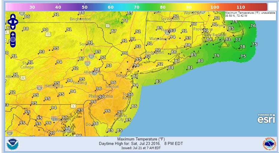
Radars are quiet and there are no issues here into Friday morning. Tonight will be warm with lows in the upper 60s to lower 70s in most places. Friday will be hot and humid with sunshine. There could be some scattered thunderstorms in the late afternoon and evening as a weak weather front approaches. This sets us up for Saturday which will be the hottest day of the summer for much of the area. Some highs in New Jersey will approach 100.
Heatwave Begins Today For Some
Saturday’s Forecast Highs
FiOS1 News Weather Forecast For Long Island
FiOS1 News Weather Forecast For New Jersey
FiOS1 News Weather Forecast For Hudson Valley
NATIONAL WEATHER SERVICE SNOW FORECASTS
LATEST JOESTRADAMUS ON THE LONG RANGE
Weather App

Don’t be without Meteorologist Joe Cioffi’s weather app. It is really a meteorologist app because you get my forecasts and my analysis and not some automated computer generated forecast based on the GFS model. This is why your app forecast changes every 6 hours. It is model driven with no human input at all. It gives you an icon, a temperature and no insight whatsoever.
It is a complete weather app to suit your forecast needs. All the weather information you need is right on your phone. Android or I-phone, use it to keep track of all the latest weather information and forecasts. This weather app is also free of advertising so you don’t have to worry about security issues with your device. An accurate forecast and no worries that your device is being compromised.
Use it in conjunction with my website and my facebook and twitter and you have complete weather coverage of all the latest weather and the long range outlook. The website has been redone and upgraded. Its easy to use and everything is archived so you can see how well Joe does or doesn’t do when it comes to forecasts and outlooks.
Just click on the google play button or the apple store button on the sidebar for my app which is on My Weather Concierge. Download the app for free. Subscribe to my forecasts on an ad free environment for just 99 cents a month.
Get my forecasts in the palm of your hand for less than the cost of a cup of Joe!

MENTION JOE CIOFFI AND GET A 5% DISCOUNT


