Heating In The Atmosphere Continues
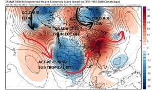
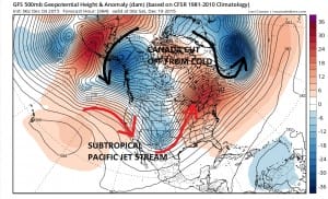
After looking over all the models from overnight it pretty well speaks the obvious that the heating in the east and cooling in the west will continue for the next few weeks. While models continue to show an active subtropical jet stream pattern coming in from the Pacific, it also continues to show no break in the pattern across the Arctic regions. Canada is completely cut off from all cold air flow from the Arctic. The European weather forecast model at day 10 shows nothing has changed. The coldest air is shown flowing in the black arrows. The positions of the upper lows in the far north show how cold air is not able to penetrate into Western or even Central Canada as the weather up there remains in a relative blow torch mode.
Nor does this change to profile in the United States wth cold air (relatively speaking) in the western states where the deep trough has resided for weeks while in the east ridge after ridge pops up along the east coast. It simply can’t get cold this way. Nothing in any of the overnight models including the fabulous GFS weather forecasting model out to day 16 shows any thing resembling a change in the pattern or even a gentle shift.
This takes us out to December 19th. The implication here is that virtually 2/3rds of the month and possibly through Christmas will remain above normal temperature wise in the east and below normal in the west. Here are my conclusions regarding this with regards to the longer term. No matter what the various long term signals be it the oscillations of the North Atlantic, Arctic, or the Pacific pattern, at least for now the El Nino seems to have trumped them all. Secondly, even though the El Nino has peaked and will begin a gradual decline, we do not know exactly where the tipping point is that switches the pattern around. Is the tipping point a month from now, two months from now, or longer. The peak does not necessarily mean the end of the current regime in the atmosphere. The el nino is trumping everything at the moment and for the foreseeable future.
UPDATED WINTER FORECAST
We are beginning to see a number of long range weather forecasters that went for an active winter throwing in the towel including Accu-weather and the Weather Channel. Perhaps as a contrary indicator this is a psychological good sign for cold and snow lovers. They haven’t exactly hit it out of the park. As to JOESTRADAMUS and HIS WINTER FORECAST if you recall I predicted a much more variable winter with no unrelenting cold like the last 2 winters and perhaps snowfall that winds up closer to normal along with closer to normal temps when you average out the three months. This certainly gives me much more wiggle room and more time. I’m not making any change to my original prediction at this point and certainly am not going to change it 3 days into December.
On the other side of this equation I would just point out that December of 1988 was among the 5 coldest Decembers on record in the New York City area. That pattern wound up flipping right after Christmas and the rest of the winter turned out to be a blow torch. There is precedent for patterns to flip on a dime. I wouldn’t necessarily bet money on this but it is certainly possible. I would also point out to last December which was an above normal relatively snowless month which lasted into mid January before the flip came. The point is we only know what we know now which is El Nino is ruling the pattern with impunity. Where the breaking point is, we just simply don’t know.
SHORT RANGE FORECAST NEW YORK, NEW JERSEY, CONNECTICUT, PENNSYLVANIA
JOESTRADAMUS VIDEO ANALYSIS FROM TUESDAY
JOESTRADAMUS LONG RANGE POST TUESDAY
JOESTRADAMUS LONG RANGE POST FROM MONDAY
JOESTRADAMUS WINTER FORECAST 2015-2016


